Current Weather/Notams (Metars, TAFs, Notams, NWS Forecast, PIREPS, and nearby weather)
Customs Information Send updates to Support@FltPlan.com
Customs Not Available
Database effective 04/18/2024
Airport Diagram might not be current.
|
| Facility Name: | KEMMERER MUNI |
| City Name: | KEMMERER |
| County: | LINCOLN |
| State abbrev: | WY |
| State Name: | WYOMING |
| | |
| Ownership: | PUBLICLY OWNED |
| Use: | OPEN TO THE PUBLIC |
| Owner's Name: | CITY OF KEMMERER; ALSO LINCOLN COUNTY - 307-877-9056 |
| Address: | 220 WYO HIWAY 233 |
| | KEMMERER, WY 83101 |
| Owner's Phone: | 307-828-2350 |
| | |
| Manager's Name: | CHAD NIELSON |
| Address: | 220 WYO HIWAY. 233 |
| | KEMMERER, WY 83101 |
| Phone: | (307) 727-7865; FOR ASSISTANCE AFT HRS PHONE 307-727-7856 |
| | |
| FAA Region: | NORTHWEST MOUNTAIN |
| FAA Field Office: | DEN |
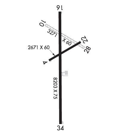
Runway Identifications
Runway Identification: 04/22Length: 2671 ft
Width: 60 ft
Surface: CONCRETE-FAIR CONDITION
Edge lights: Medium IntensityTreatment: NONE
| | Runway: 04 | | Runway: 22 |
| Mag heading: | 43° | Mag heading: | 223° |
| Rwy Slope: | -.06% Down | Rwy Slope: | .06% Up |
| Approach: | | Approach: | |
| Pattern: | Left Traffic | Pattern: | Right Traffic |
| Markings: | BASIC | Markings: | BASIC |
| Marking Condition: | FAIR | Marking Condition: | FAIR |
| Arresting Dev: | | Arresting Dev: | |
| Lat & Long: | N4149.4 W11033.6 | Lat. & Long.: | N4149.7 W11033.2 |
| Elev: | 7285.8 ft. MSL | Elev: | 7284.3 ft. MSL |
| TCH: | | TCH: | |
| Visual Glide Path: | | Visual Glide Path: | |
| Displaced Threshold: | No | Displaced Threshold: | No |
| Touchdown Zone: | YES | Touchdown Zone: | YES |
| Touchdown Elev.: | 7285.8 feet | Touchdown Elev.: | 7285.8 feet |
| Visual Glide Slope: | | Visual Glide Slope: | |
| RVR Equipment: | | RVR Equipment: | |
| RVV Equipment: | NO | RVV Equipment: | NO |
| Approach Lights: | | Approach Lights: | |
| REIL: | NO | REIL: | NO |
| Centerline Lights: | NO | Centerline Lights: | NO |
| Touchdown lights: | NO | Touchdown lights: | NO |
| Runway Category: | Runway with a Visual Approach | Runway Category: | Runway with a Visual Approach |
| Declared Distances: | | Declared Distances: | |
Runway Identification: 10/28Length: 3271 ft
Width: 60 ft
Surface: GRASS NATURAL SOIL-FAIR CONDITION
Edge lights: Treatment: NONE
| | Runway: 10 | | Runway: 28 |
| Mag heading: | 110° | Mag heading: | 290° |
| Rwy Slope: | -.22% Down | Rwy Slope: | .22% Up |
| Approach: | | Approach: | |
| Pattern: | Left Traffic | Pattern: | Left Traffic |
| Markings: | NONE | Markings: | NONE |
| Marking Condition: | GOOD | Marking Condition: | GOOD |
| Arresting Dev: | | Arresting Dev: | |
| Lat & Long: | N4149.8 W11033.7 | Lat. & Long.: | N4149.6 W11033.1 |
| Elev: | 7287.2 ft. MSL | Elev: | 7280.1 ft. MSL |
| TCH: | | TCH: | |
| Visual Glide Path: | | Visual Glide Path: | |
| Displaced Threshold: | No | Displaced Threshold: | No |
| Touchdown Zone: | YES | Touchdown Zone: | YES |
| Touchdown Elev.: | 7287.5 feet | Touchdown Elev.: | 7286.9 feet |
| Visual Glide Slope: | | Visual Glide Slope: | |
| RVR Equipment: | | RVR Equipment: | |
| RVV Equipment: | NO | RVV Equipment: | NO |
| Approach Lights: | | Approach Lights: | |
| REIL: | NO | REIL: | NO |
| Centerline Lights: | NO | Centerline Lights: | NO |
| Touchdown lights: | NO | Touchdown lights: | NO |
| Runway Category: | Runway with a Visual Approach | Runway Category: | Runway with a Visual Approach |
| Declared Distances: | | Declared Distances: | |
| Obstructions: | | Obstructions: | FENCE |
| Marked: | | Marked: | NOT Marked/Lighted |
| Clearance slope: | 50:1 | Clearance slope: | 16:1 |
| Obstruction height: | | Obstruction height: | 7 feet AGL |
| Dist. from runway: | | Dist. from runway: | 105 feet |
| Centerline offset: | | Centerline offset: | |
| Comments: | | Comments: | |
Runway Identification: 16/34Length: 8203 ft
Width: 75 ft
Surface: ASPHALT-GOOD CONDITION
Edge lights: Medium IntensityTreatment: NONE
| | Runway: 16 | | Runway: 34 |
| Mag heading: | 163° | Mag heading: | 343° |
| Rwy Slope: | -.16% Down | Rwy Slope: | .16% Up |
| Approach: | | Approach: | |
| Pattern: | Left Traffic | Pattern: | Left Traffic |
| Markings: | NONPRECISION INSTRUMENT | Markings: | NONPRECISION INSTRUMENT |
| Marking Condition: | GOOD | Marking Condition: | GOOD |
| Arresting Dev: | | Arresting Dev: | |
| Lat & Long: | N4150.0 W11033.5 | Lat. & Long.: | N4148.6 W11033.3 |
| Elev: | 7288.7 ft. MSL | Elev: | 7275.9 ft. MSL |
| TCH: | 34 ft. AGL | TCH: | 61 ft. AGL |
| Visual Glide Path: | 3.25 degrees | Visual Glide Path: | 3.25 degrees |
| Displaced Threshold: | No | Displaced Threshold: | No |
| Touchdown Zone: | YES | Touchdown Zone: | YES |
| Touchdown Elev.: | 7288.7 feet | Touchdown Elev.: | 7279.6 feet |
| Visual Glide Slope: | 2-Light PAPI on LEFT side of Runway | Visual Glide Slope: | 2-Light PAPI on LEFT side of Runway |
| RVR Equipment: | | RVR Equipment: | |
| RVV Equipment: | NO | RVV Equipment: | NO |
| Approach Lights: | | Approach Lights: | |
| REIL: | YES | REIL: | YES |
| Centerline Lights: | NO | Centerline Lights: | NO |
| Touchdown lights: | NO | Touchdown lights: | NO |
| Runway Category: | Runway with a Non-precision Approach having visibility minimums greater than 3/4 mile | Runway Category: | Runway with a Non-precision Approach having visibility minimums greater than 3/4 mile |
| Declared Distances: | | Declared Distances: | |

