Click here for more info on on SMS!

KELP

EL PASO INTL
EL PASO
TX
Time Zone: Mountain
Lat: N 3148.4
Long: W 10622.6
Elev: 3962
Var: -08
Longest Runway: 12020
Clr Del: 125.0
Dept. ATIS: 120.0
Arr. ATIS: 120.0
Ground: 121.9
Tower: 118.3

FBO & Flight Services info for KELP

FBOs: Update your Fuel Prices
Atlantic Aviation is your premier aviation service provider with more than 100 locations in North America, including Hawaii and the Caribbean. We provide standard ground services you'd expect, with a detailed focus on ensuring an unforgettable customer experience.
Ph: 915-779-2831 Fax: 915-775-0833 Freq: 128.85WebsiteE-Mail
                     
Service
Jet
100LL
SAF
MoGas
Full7.108.15    Last Update: 04/24/2024 13:37:44

Self        
Misc. Info: All prices are 'Out The Door', call for volume discountsAddress: 1751 SHUTTLE COLUMBIA   EL PASO, TX 79925

  click here  
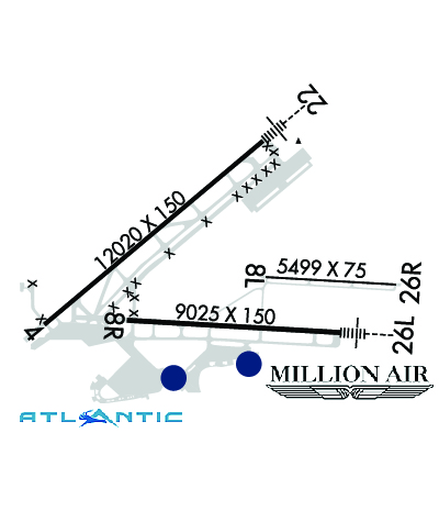
Just 8.5 miles east of downtown El Paso, Million Air ELP boasts a 10,000 sf VIP lobby, 20,000 sf of hangar space, an aircraft porte-cochere, and ramp space to support any aircraft. The new GA terminal offers a Cafe, refreshment bar, pilot's lounge, snooze rooms, state-of-the-art flight planning room, and a multi-media conference room - with Million Air's concierge approach to fine service.
Ph: 915-235-9357 Fax: 915-219-5368 Freq: 129.87WebsiteE-Mail
                     
Service
Jet
100LL
SAF
MoGas
Fuel Avail: Hours of Operation - 0600 to 2400, Call main number or +1-915-202-6733 for after hours
Full7.038.20    Last Update: 04/22/2024 16:14

There's an additional .11 cents per gallon for jet a with addictive.
Self  7.20    
Misc. Info: UNICOM FREQUENCY: 129.875Address: 1800 HAWKINS EL PASO, TX, 79925

ASOSPh: 915-779-6452
-
-
 
ATISPh: 915-772-9412
-
-
 
If you are an FBO, call 1-203-262-1700 to update your info or email: FltPlan.Advertising@garmin.com
Advertise your FBO on FltPlan.com

Runway & Approach Info for KELP
Rwy
Length
Land Dist**
Approach*
  Rwy
Length
Land Dist**
Approach*
04
12020x150  12020'          
LOC/DME
 111.50 - 041°  
  
22
  12020x150  12020'          
ILS/DME
 111.50 - 222°  
08L
5499x75  5499'          
 
  
26R
  5499x75  5499'          
 
08R
9025x150  9025'          
 
  
26L
  9025x150  9025'          
 
 * only ILS, LOC, LDA, and SDF approaches to a specific runway are shown
** For any Declared Landing Distance Available, please see A/FD or Approach plates
Runway Weight Capability (lbs.) Help
Runway IDSingle WheelDouble WheelDouble Tandem WheelDual Double Wheel
04/22100,000180,000350,000N/A
08L/26R60,000180,000N/AN/A
08R/26L100,000180,000350,000N/A
These numbers are Advisory and are not limits.   The Airport Manager should have more accurate Weight Limits
Approach Charts
Approaches    
Current Weather/Notams
Customs Information Send updates to Support@FltPlan.com
Phone 915-730-7890
Fax 915-782-4702

Comments 1 hr advance notice required. Business hrs 0800-2400 Monday-Friday. *Call prior to 2400 on preceding weekday.
Database effective 05/16/2024
Airport Diagram of KELP
Airport Diagram might not be current.

Facility Name: EL PASO INTL
City Name: EL PASO
County: EL PASO
State abbrev: TX
State Name: TEXAS
   
Ownership: PUBLICLY OWNED
Use: OPEN TO THE PUBLIC
Owner's Name: CITY OF EL PASO
Address: 300 N. CAMPBELL
 EL PASO, TX 79901
Owner's Phone: (915) 212-0000
  
Manager's Name: SAM RODRIGUEZ
Address: 6701 CONVAIR RD
 EL PASO, TX 79925
Phone: 915-212-0333
   
FAA Region: SOUTHWEST
FAA Field Office: TEX


Sunrise / Sunset times for EL PASO INTL

DateSunriseSunset
04/23/24 Tuesday6:2719:41
04/24/24 Wednesday6:2619:41
04/25/24 Thursday6:2519:42
04/26/24 Friday6:2419:43
04/27/24 Saturday6:2319:44
04/28/24 Sunday6:2219:44
04/29/24 Monday6:2119:45
04/30/24 Tuesday6:2019:46
05/01/24 Wednesday6:1919:46
05/02/24 Thursday6:1819:47
05/03/24 Friday6:1719:48
05/04/24 Saturday6:1619:48
05/05/24 Sunday6:1619:49
05/06/24 Monday6:1519:50

Airport Facilities

Airport Attendance ScheduleCONTINUOUS
Airport Status OPERATIONAL (This Status can change at any time - please check NOTAMS)
Airport Lighting ScheduleSS-SR
Airport Storage AvailableTie Downs, Hanger
Extra Services AvailableAir Freight, Air Ambulance, Avionics, Cargo Handling, Charter, Flight Instruction, Aircraft Rental, Aircraft Sales
Wind IndicatorYES - (lighted)
Control TowerYES
CTAF Frequency
Unicom Frequency122.950
Rotating Beacon ColorWG
Segmented CircleNO
Landing FeeNO

Airport Inspection Data

Airport InspectedFEDERAL - performed by FAA AIRPORTS FIELD PERSONNEL
Inspection Date08/17/2023

Airport Services

Type of Fuel AvailableGrade 100LL, JET A-1 (icing inhibitor, freeze point -50C); -10FOR FUEL AT MIL RAMP CTC ATLANTIC AVIATION 122.95 OR 915-779-2831.
Airframe Repair ServiceMAJOR
Power Plant Repair ServiceMAJOR

Geographic Data

LatitudeN3148.4
LongitudeW10622.6 (ESTIMATED)
Arpt Elevation3961ft (SURVEYED)
Magnetic Variation08E
4 miles NEof EL PASO
Traffic Pattern AltitudeTPA: 1038 FT AGL SMALL ACFT, 1542 FT AGL TURBOJET, 2042 FT AGL OVERHEAD APCH.
Sectional ChartEL PASO

Aircraft Data

Operations (Reported)YearlyAvg. Daily
General Aviation Transient 2595171
General Aviation Local 568616
Air Taxi 1635045
Commerical 48574133
Commuter 00
Military 685319
Aircraft based on Field
General Aviation Singles 122
General Aviation Multi 21
Jet Aircraft 44
General Aviation Helicopters 12
Military Aircraft 0
Gliders 0
Ultralights 0

FAA Services

FSS on field NO
FSS tie-in ALBUQUERQUE
FSS Phone 1-800-WX-BRIEF
Who issues Notams ELP
Notam D service at airport YES
ARTCC Name ALBUQUERQUE

Federal Status

Airport CertificationAIRPORT RECEIVING SCHEDULED AIR CARRIER SERVICE FROM CARRIERS CERTIFICATED BY THE CIVIL AERONAUTICS BOARD
Aircraft Rescue & Firefighting IndexAIRPORT HAS A CERTIFICATE UNDER CFR PART 139
Airport of EntryYES
Custom Landing RightsNo
Joint Civil/MilitaryNo
Military Landing rightsYES

Federal Agreements

NATIONAL PLAN OF INTEGRATED AIRPORT SYSTEMS (NPIAS)
GRANT AGREEMENTS UNDER FAAP/ADAP/AIP
SURPLUS PROPERTY AGREEMENT UNDER PUBLIC LAW 289
SURPLUS PROPERTY AGREEMENT UNDER REGULATION 16-WAA
ASSURANCES PURSUANT TO TITLE VI, CIVIL RIGHTS ACT OF 1964
AGREEMENT UNDER DLAND OR DCLA HAS EXPIRED.

Remarks

24 HR PPR CLASS A EXPLOSIVES CTC 915-212-0333.
HOLDING POSITION MARKINGS FOR RUNWAY 8R APPROACH AND RUNWAY 4/22 ARE IN CLOSE PROXIMITY TO THE TERMINAL APRON; REVIEW AIRPORT DIAGRAM PRIOR TO PUSHBACK FROM THE GATE.
MILITARY USERS SHOULD REVIEW NOISE ABATEMENT PROCEDURES LISTED FOR BIGGS AAF.
NOISE ABATEMENT PROCEDURES IN EFFECT, CTC ATCT FOR DETAILS.
ENGINE POWER IS RSTRD TO IDLE POWER ON ONE ENGINE AT A TIME FOR MAX 5 MIN ON ANY TERMINAL OR PARKING APRONS, CROSS-BLEED STARTS OR OTHER PRE DEP ACTIVITY ON MOVEMENT AREAS ONLY, MAINT OR OTR RQRMT NEEDING LONGER OR HIGHER POWER CTC TWR FOR DIRECTIONS TO DESIGNATED RUNUP AREAS.
COMPASS ROSE CLSD PERMLY.
CTN: BIGGS AAF 2NM NW RWY 22 CAN BE MISTAKEN FOR ELP RWY 22.
NORTH BOUND TFC PROHIBITED ON TWY F SOUTH OF APCH END RWY 08R.
TWY A SOUTH OF APCH END OF RWY 4; TWY J NE OF TWY K1; TWY K NE OF TWY K1 BTN TWY J & NORTH CARGO RAMP; TWYS U & V SOUTH OF TWY L; & TWY K2 NOT VISIBLE FM ATCT.
RWY 08L/ 26RRWY NOT AVBL FOR ACR OPS WITH MORE THAN 9 PSGR SEATS.
RWY 04/2 2 RWY 4/22 206 FEET CONC, 10,814 FEET ASPH, 1,000 FEET CONC.
RWY 08R/ 26LRWY 08R/26L 7,780 FEET ASPH, 1,247 FEET CONC.
Airport Communications & Frequencies:
ATIS Frequencies:   Hours(local) of Operation: CONTINUOUS
120.0
254.3
EL PASO Tower Frequencies:   Hours(local) of operation: CONTINUOUS   
118.3
239.275
EL PASO Ground Frequencies:
121.9
348.6
Clearance Delivery Frequencies:
125.0
379.1
Pre-Taxi Clearance Frequencies:
125.0
Emergency Frequencies:
121.5
243.0
Unicom Frequency:
122.950
EL PASO Primary Approach Frequencies:   Hours(local) of operation: CONTINUOUS   
119.15 ;SOUTH-V16
124.25 ;NORTH-V16
298.85 ;NORTH-V16
353.5 ;SOUTH-V16
EL PASO Primary Departure Frequencies:   Hours(local) of operation: CONTINUOUS   
119.15
263.0
Class C Frequencies:
119.15 ;SOUTH-V16
119.15
124.25 ;NORTH-V16
298.85 ;NORTH-V16
353.5 ;SOUTH-V16
Runway Identifications
Runway Identification: 04/22
Length: 12020 ft
Width: 150 ft
Surface: CONCRETE ASPHALT-FAIR CONDITION
Edge lights: High Intensity

Treatment: GROOVED
Weight: PCN 70 /R/B/X/T

 Runway: 04   Runway: 22
Mag heading: 42°Mag heading: 222°
Rwy Slope: .27% UpRwy Slope: -.27% Down
Approach: LOC/DMEApproach: ILS/DME
Pattern: Left TrafficPattern: Right Traffic
Markings: PRECISION INSTRUMENTMarkings: PRECISION INSTRUMENT
Marking Condition: GOODMarking Condition: GOOD
Arresting Dev: Arresting Dev:
Lat & Long: N3148.1  W10624.0Lat. & Long.: N3149.4  W10622.2
Elev: 3916.9 ft. MSLElev: 3949.5 ft. MSL
TCH: 55 ft. AGLTCH: 70 ft. AGL
Visual Glide Path: 3.00 degreesVisual Glide Path: 3.00 degrees
Displaced Threshold: NoDisplaced Threshold: No
Touchdown Zone: YESTouchdown Zone: YES
Touchdown Elev.: 3923.2 feetTouchdown Elev.: 3949.5 feet
Visual Glide Slope: 4-Light PAPI on LEFT side of RunwayVisual Glide Slope: 4-Light PAPI on RIGHT side of Runway
RVR Equipment: TOUCHDOWN-ROLLOUTRVR Equipment: TOUCHDOWN-ROLLOUT
RVV Equipment: NORVV Equipment: NO
Approach Lights: Approach Lights: MALSR - 1,400 foot medium intensity approach lighting system with runway alignment indicator lights
REIL: YESREIL: NO
Centerline Lights: NOCenterline Lights: NO
Touchdown lights: NOTouchdown lights: NO
Runway Category: Runway with a Non-precision Approach having visibility minimums greater than 3/4 mileRunway Category: Precision Instrument Runway
Declared Distances: TORA:12020' TODA:12020' ASDA:12020' LDA:12020'Declared Distances: TORA:12020' TODA:12020' ASDA:12020' LDA:12020'
Runway Identification: 08L/26R
Length: 5499 ft
Width: 75 ft
Surface: CONCRETE-GOOD CONDITION
Edge lights: Medium Intensity

Treatment: GROOVED
Weight: PCN 10 /R/C/W/T

 Runway: 08L   Runway: 26R
Mag heading: 85°Mag heading: 265°
Rwy Slope: -.06% DownRwy Slope: .06% Up
Approach: Approach:
Pattern: Left TrafficPattern: Right Traffic
Markings: BASICMarkings: NONPRECISION INSTRUMENT
Marking Condition: GOODMarking Condition: GOOD
Arresting Dev: Arresting Dev:
Lat & Long: N3148.4  W10622.2Lat. & Long.: N3148.4  W10621.1
Elev: 3952.6 ft. MSLElev: 3949.2 ft. MSL
TCH: TCH:
Visual Glide Path: Visual Glide Path:
Displaced Threshold: NoDisplaced Threshold: No
Touchdown Zone: YESTouchdown Zone: YES
Touchdown Elev.: 3952.7 feetTouchdown Elev.: 3949.5 feet
Visual Glide Slope: Visual Glide Slope:
RVR Equipment: RVR Equipment:
RVV Equipment: NORVV Equipment: NO
Approach Lights: Approach Lights:
REIL: NOREIL: NO
Centerline Lights: NOCenterline Lights: NO
Touchdown lights: NOTouchdown lights: NO
Runway Category: Runway with a Visual ApproachRunway Category: Runway with a Visual Approach
Declared Distances: TORA:5499' TODA:5499' ASDA:5499' LDA:5499'Declared Distances: TORA:5499' TODA:5499' ASDA:5499' LDA:5499'
Runway Identification: 08R/26L
Length: 9025 ft
Width: 150 ft
Surface: CONCRETE ASPHALT-FAIR CONDITION
Edge lights: High Intensity

Treatment: GROOVED
Weight: PCN 75 /F/B/W/T

 Runway: 08R   Runway: 26L
Mag heading: 85°Mag heading: 265°
Rwy Slope: .38% UpRwy Slope: -.38% Down
Approach: Approach:
Pattern: Right TrafficPattern: Left Traffic
Markings: NONPRECISION INSTRUMENTMarkings: NONPRECISION INSTRUMENT
Marking Condition: GOODMarking Condition: GOOD
Arresting Dev: Arresting Dev:
Lat & Long: N3148.1  W10623.3Lat. & Long.: N3148.0  W10621.6
Elev: 3927.1 ft. MSLElev: 3961.6 ft. MSL
TCH: 75 ft. AGLTCH: 75 ft. AGL
Visual Glide Path: 3.00 degreesVisual Glide Path: 3.00 degrees
Displaced Threshold: NoDisplaced Threshold: No
Touchdown Zone: YESTouchdown Zone: YES
Touchdown Elev.: 3940.3 feetTouchdown Elev.: 3961.6 feet
Visual Glide Slope: 4-Light PAPI on LEFT side of RunwayVisual Glide Slope: 4-Light PAPI on RIGHT side of Runway
RVR Equipment: RVR Equipment:
RVV Equipment: NORVV Equipment: NO
Approach Lights: Approach Lights: MALSR - 1,400 foot medium intensity approach lighting system with runway alignment indicator lights
REIL: YESREIL: NO
Centerline Lights: NOCenterline Lights: NO
Touchdown lights: NOTouchdown lights: NO
Runway Category: Runway with a Visual ApproachRunway Category: D
Declared Distances: TORA:9025' TODA:9025' ASDA:9025' LDA:9025'Declared Distances: TORA:9025' TODA:9025' ASDA:9025' LDA:9025'
C:155/P: