Click here for more info on on SMS!

KELO

ELY MUNI
ELY
MN
Time Zone: Central
Lat: N 4749.4
Long: W 09149.8
Elev: 1456
Var: -00
Longest Runway: 5596
AWOS: 132.02
CTAF: 122.8

FBO & Flight Services info for KELO

FBOs: Update your Fuel Prices

J & A ENTERPRISEPh: 218-365-5600 Fax: 218-365-3110 Freq: 122.8
Service
Jet
100LL
SAF
MoGas
Fuel Avail: PRIST PREMIXED. 8A-5P. AFTR HRS call required
Full6.256.25    Caution: Fuel prices have not been updated in 31 days.
Last Update: 03/23/2024 13:33

Self        
 Address: 1583 HIGHWAY 1   ELY, MN 55731
AWOSPh: 218-365-3814
-
Freq: 132.02  
If you are an FBO, call 1-203-262-1700 to update your info or email: FltPlan.Advertising@garmin.com
Advertise your FBO on FltPlan.com

Runway & Approach Info for KELO
Rwy
Length
Land Dist**
Approach*
  Rwy
Length
Land Dist**
Approach*
12
5596x100  5596'          
 
  
30
  5596x100  5596'          
 
 * only ILS, LOC, LDA, and SDF approaches to a specific runway are shown
** For any Declared Landing Distance Available, please see A/FD or Approach plates
Runway Weight Capability (lbs.) Help
Runway IDSingle WheelDouble WheelDouble Tandem WheelDual Double Wheel
12/3099,000159,000N/AN/A
These numbers are Advisory and are not limits.   The Airport Manager should have more accurate Weight Limits
Approach Charts
Approaches    
Current Weather/Notams
Customs Information Send updates to Support@FltPlan.com
Phone 218-365-3262
Fax N/A

Comments Mon-Sun 0830-1630 On call basis. 1 hr advance notice required.
Database effective 05/16/2024
Airport Diagram of KELO
Airport Diagram might not be current.

Facility Name: ELY MUNI
City Name: ELY
County: ST LOUIS
State abbrev: MN
State Name: MINNESOTA
   
Ownership: PUBLICLY OWNED
Use: OPEN TO THE PUBLIC
Owner's Name: CITY OF ELY
Address: 209 E CHAPMAN ST
 ELY, MN 55731-1471
Owner's Phone: 218-365-3224
  
Manager's Name: JIM PREBLICH
Address: 1583 HIGHWAY 1
 ELY, MN 55731-8209
Phone: 218-365-5600
   
FAA Region: GREAT LAKES
FAA Field Office: DMA


Sunrise / Sunset times for ELY MUNI

DateSunriseSunset
04/22/24 Monday6:0420:08
04/23/24 Tuesday6:0220:10
04/24/24 Wednesday6:0020:11
04/25/24 Thursday5:5820:13
04/26/24 Friday5:5720:14
04/27/24 Saturday5:5520:16
04/28/24 Sunday5:5320:17
04/29/24 Monday5:5220:18
04/30/24 Tuesday5:5020:20
05/01/24 Wednesday5:4820:21
05/02/24 Thursday5:4720:23
05/03/24 Friday5:4520:24
05/04/24 Saturday5:4420:25
05/05/24 Sunday5:4220:27

Airport Facilities

Airport Attendance Schedule7 Days A Week 0800-1700; FOR ATTENDANT AFT HRS CALL 218-343-8774.
Airport Status OPERATIONAL (This Status can change at any time - please check NOTAMS)
Airport Lighting ScheduleACTVT OR INCR INTST REIL RWY 12 & 30; PAPI RWY 12 & 30; MIRL RWY 12/30 - CTAF. MIRL RWY 12/30 PRESET LOW INTST.
Airport Storage AvailableTie Downs, Hanger
Extra Services AvailableNONE
Wind IndicatorYES - (lighted)
Control TowerNO
CTAF Frequency122.800
Unicom Frequency122.800
Rotating Beacon ColorWG
Segmented CircleYES
Landing FeeNO

Airport Inspection Data

Airport InspectedSTATE - performed by STATE AERONAUTICAL PERSONNEL
Inspection Date07/06/2023

Airport Services

Type of Fuel AvailableGrade 100LL, JET A (freeze point -40C)
Airframe Repair ServiceNONE
Power Plant Repair ServiceNONE

Geographic Data

LatitudeN4749.4
LongitudeW09149.8 (ESTIMATED)
Arpt Elevation1456ft (SURVEYED)
Magnetic Variation00E
4 miles Sof ELY
Traffic Pattern Altitude
Sectional ChartGREEN BAY

Aircraft Data

Operations (Reported)YearlyAvg. Daily
General Aviation Transient 30008
General Aviation Local 500014
Air Taxi 2001
Commerical 00
Commuter 00
Military 00
Aircraft based on Field
General Aviation Singles 22
General Aviation Multi 0
Jet Aircraft 1
General Aviation Helicopters 0
Military Aircraft 0
Gliders 0
Ultralights 0

FAA Services

FSS on field NO
FSS tie-in PRINCETON
FSS Phone 1-800-WX-BRIEF
Who issues Notams ELO
Notam D service at airport YES
ARTCC Name MINNEAPOLIS

Federal Status

Airport Certification
Aircraft Rescue & Firefighting IndexNone
Airport of EntryNo
Custom Landing RightsYES
Joint Civil/MilitaryNo
Military Landing rightsYES

Federal Agreements

NATIONAL PLAN OF INTEGRATED AIRPORT SYSTEMS (NPIAS)
GRANT AGREEMENTS UNDER FAAP/ADAP/AIP
CONVEYANCE UNDER SCETION 16, FEDERAL AIRPORT ACT OF 1946 OR SECTION 23, AIRPORT AND AIRWAY DEVELOPMENT ACT OF 1970
ADVANCE PLANNING AGREEMENT UNDER FAAP
ASSURANCES PURSUANT TO TITLE VI, CIVIL RIGHTS ACT OF 1964

Remarks

FOR CD CTC MINNEAPOLIS ARTCC AT 651-463-5588.
Airport Communications & Frequencies:
CTAF Frequency:
122.800
Unicom Frequency:
122.800
Remarks
  • APCH/DEP SVC PRVDD BY MINNEAPOLIS ARTCC (ZMP) ON FREQS 127.9/281.45 (DULUTH RCAG).
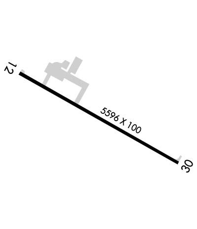
  • Runway Identifications
    Runway Identification: 12/30
    Length: 5596 ft
    Width: 100 ft
    Surface: ASPHALT-GOOD CONDITION
    Edge lights: Medium Intensity

    Treatment: NONE
    Weight: PCN 39 /F/B/X/U

     Runway: 12   Runway: 30
    Mag heading: 120°Mag heading: 300°
    Rwy Slope: .23% UpRwy Slope: -.23% Down
    Approach: Approach:
    Pattern: Left TrafficPattern: Left Traffic
    Markings: NONPRECISION INSTRUMENTMarkings: NONPRECISION INSTRUMENT
    Marking Condition: GOODMarking Condition: GOOD
    Arresting Dev: Arresting Dev:
    Lat & Long: N4749.7  W09150.4Lat. & Long.: N4749.2  W09149.2
    Elev: 1443.0 ft. MSLElev: 1455.6 ft. MSL
    TCH: 40 ft. AGLTCH: 41 ft. AGL
    Visual Glide Path: 3.00 degreesVisual Glide Path: 3.00 degrees
    Displaced Threshold: NoDisplaced Threshold: No
    Touchdown Zone: YESTouchdown Zone: YES
    Touchdown Elev.: 1451.9 feetTouchdown Elev.: 1456.0 feet
    Visual Glide Slope: 4-Light PAPI on LEFT side of RunwayVisual Glide Slope: 4-Light PAPI on LEFT side of Runway
    RVR Equipment: RVR Equipment:
    RVV Equipment: NORVV Equipment: NO
    Approach Lights: Approach Lights:
    REIL: YESREIL: YES
    Centerline Lights: NOCenterline Lights: NO
    Touchdown lights: NOTouchdown lights: NO
    Runway Category: Runway with a Non-precision Approach having visibility minimums greater than 3/4 mileRunway Category: Runway with a Non-precision Approach having visibility minimums greater than 3/4 mile
    Declared Distances: Declared Distances:
    Obstructions: Obstructions: TREE
    Marked: Marked: NOT Marked/Lighted
    Clearance slope: 34:1Clearance slope: 28:1
    Obstruction height: Obstruction height: 90 feet AGL
    Dist. from runway: Dist. from runway: 2760 feet
    Centerline offset: Centerline offset: 616 feet left of centerline
    Comments: Comments:
    C:3/P: