Current Weather/Notams (Metars, TAFs, Notams, NWS Forecast, PIREPS, and nearby weather)
Customs Information Send updates to Support@FltPlan.com
Customs Not Available
Database effective 04/18/2024
Airport Diagram might not be current.
|
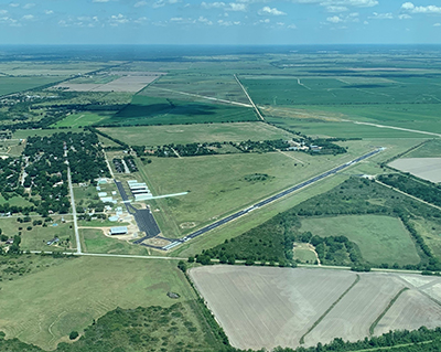
| Facility Name: | EAGLE LAKE |
| City Name: | EAGLE LAKE |
| County: | COLORADO |
| State abbrev: | TX |
| State Name: | TEXAS |
| | |
| Ownership: | PUBLICLY OWNED |
| Use: | OPEN TO THE PUBLIC |
| Owner's Name: | CITY OF EAGLE LAKE |
| Address: | PO BOX 38 |
| | EAGLE LAKE, TX 77434 |
| Owner's Phone: | 979-234-2640 |
| | |
| Manager's Name: | VICTOR SHIMEK; CITY INSPECTOR/ARPT MGR. |
| Address: | PO BOX 38 |
| | EAGLE LAKE, TX 77434 |
| Phone: | 979-234-2640 |
| | |
| FAA Region: | SOUTHWEST |
| FAA Field Office: | TEX |
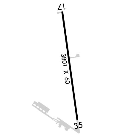
Runway Identifications
Runway Identification: 17/35Length: 4280 ft
Width: 60 ft
Surface: ASPHALT-GOOD CONDITION
Edge lights: Medium IntensityTreatment: NONE
| | Runway: 17 | | Runway: 35 |
| Mag heading: | 166° | Mag heading: | 346° |
| Rwy Slope: | -.05% Down | Rwy Slope: | .05% Up |
| Approach: | | Approach: | |
| Pattern: | Left Traffic | Pattern: | Right Traffic |
| Markings: | NONPRECISION INSTRUMENT | Markings: | NONPRECISION INSTRUMENT |
| Marking Condition: | GOOD | Marking Condition: | GOOD |
| Arresting Dev: | | Arresting Dev: | |
| Lat & Long: | N2936.4 W09619.4 | Lat. & Long.: | N2935.7 W09619.3 |
| Elev: | 183.9 ft. MSL | Elev: | 181.9 ft. MSL |
| TCH: | 48 ft. AGL | TCH: | 40 ft. AGL |
| Visual Glide Path: | 3.00 degrees | Visual Glide Path: | 3.00 degrees |
| Displaced Threshold: | No | Displaced Threshold: | No |
| Touchdown Zone: | YES | Touchdown Zone: | YES |
| Touchdown Elev.: | 184.1 feet | Touchdown Elev.: | 183.8 feet |
| Visual Glide Slope: | 2-Light PAPI on LEFT side of Runway | Visual Glide Slope: | 2-Light PAPI on LEFT side of Runway |
| RVR Equipment: | | RVR Equipment: | |
| RVV Equipment: | NO | RVV Equipment: | NO |
| Approach Lights: | | Approach Lights: | |
| REIL: | NO | REIL: | NO |
| Centerline Lights: | NO | Centerline Lights: | NO |
| Touchdown lights: | NO | Touchdown lights: | NO |
| Runway Category: | Runway with a Non-precision Approach | Runway Category: | Runway with a Non-precision Approach |
| Declared Distances: | | Declared Distances: | |
| Obstructions: | | Obstructions: | ROAD |
| Marked: | | Marked: | NOT Marked/Lighted |
| Clearance slope: | 20:1 | Clearance slope: | |
| Obstruction height: | | Obstruction height: | 15 feet AGL |
| Dist. from runway: | | Dist. from runway: | 201 feet |
| Centerline offset: | | Centerline offset: | 69 feet left of centerline |
| Comments: | | Comments: | 15 FT RD, 68 FT DSTC, 220 FT R; 15 FT RD, 27 FT DSTC, 250 R. |