KEKY

BESSEMER
BESSEMER
AL
Time Zone: Central
Lat: N 3318.8
Long: W 08655.6
Elev: 700
Var: +03
Longest Runway: 6007
Clr Del: 123.75
AWOS: 118.82
CTAF: 123.0

FBO & Flight Services info for KEKY

FBOs: Update your Fuel Prices

BESSEMER AIRPORTPh: 205-428-9292 Fax: 205-428-9330 Freq: 123.0
Service
Jet
100LL
SAF
MoGas
Fuel Avail: PRIST+ $0.15/gal. 8:00 A.M.- 6:00 P.M. $100 fee for services before or after hours.
Full7.247.19    Last Update: 04/23/2024 09:35

Self        
 Address: 900 MITCHELL FIELD ROAD,   BESSEMER, AL 35022
AC MAINTENANCE COPh: 205-424-2377 Fax: 888-845-7739
-
AWOSPh: 205-424-3127
-
Freq: 118.82  
If you are an FBO, call 1-203-262-1700 to update your info or email: FltPlan.Advertising@garmin.com
Advertise your FBO on FltPlan.com

Runway & Approach Info for KEKY
Rwy
Length
Land Dist**
Approach*
  Rwy
Length
Land Dist**
Approach*
05
6007x100  6007'          
ILS/DME
 111.75 - 052°  
  
23
  6007x100  6007'          
 
 * only ILS, LOC, LDA, and SDF approaches to a specific runway are shown
** For any Declared Landing Distance Available, please see A/FD or Approach plates
Runway Weight Capability (lbs.) Help
Runway IDSingle WheelDouble WheelDouble Tandem WheelDual Double Wheel
05/2360,00060,000N/AN/A
These numbers are Advisory and are not limits.   The Airport Manager should have more accurate Weight Limits
Approach Charts
Approaches    
Current Weather/Notams
Customs Information Send updates to Support@FltPlan.com
Customs Not Available
Database effective 05/16/2024
Airport Diagram of KEKY
Airport Diagram might not be current.

Facility Name: BESSEMER
City Name: BESSEMER
County: JEFFERSON
State abbrev: AL
State Name: ALABAMA
   
Ownership: PUBLICLY OWNED
Use: OPEN TO THE PUBLIC
Owner's Name: CITY OF BESSEMER
Address: 1700 N THIRD AVE
 BESSEMER, AL 35020
Owner's Phone: 205-424-4060
  
Manager's Name: TIM WASYLUKA
Address: 900 MITCHELL FIELD RD
 BESSEMER, AL 35022
Phone: (205) 835-1415
   
FAA Region: SOUTHERN
FAA Field Office: JAN


Sunrise / Sunset times for BESSEMER

DateSunriseSunset
04/22/24 Monday6:0819:24
04/23/24 Tuesday6:0719:25
04/24/24 Wednesday6:0619:26
04/25/24 Thursday6:0519:26
04/26/24 Friday6:0419:27
04/27/24 Saturday6:0319:28
04/28/24 Sunday6:0219:29
04/29/24 Monday6:0119:29
04/30/24 Tuesday6:0019:30
05/01/24 Wednesday5:5919:31
05/02/24 Thursday5:5819:32
05/03/24 Friday5:5719:32
05/04/24 Saturday5:5619:33
05/05/24 Sunday5:5519:34

Airport Facilities

Airport Attendance Schedule7 Days A Week 0800-1800; FEE FOR AFT HRS SVC CALL 205-835-1415.
Airport Status OPERATIONAL (This Status can change at any time - please check NOTAMS)
Airport Lighting ScheduleACTVT REIL RWY 05 & 23; HIRL RWY 05/23 - CTAF.
Airport Storage AvailableTie Downs, Hanger
Extra Services AvailableAvionics, Flight Instruction, Aircraft Rental
Wind IndicatorYES - (lighted)
Control TowerNO
CTAF Frequency123.000
Unicom Frequency123.000
Rotating Beacon ColorWG
Segmented CircleYES
Landing FeeNO

Airport Inspection Data

Airport InspectedSTATE - performed by STATE AERONAUTICAL PERSONNEL
Inspection Date06/15/2023

Airport Services

Type of Fuel AvailableGrade 100LL, JET A (freeze point -40C), JET A
Airframe Repair ServiceMAJOR
Power Plant Repair ServiceMAJOR

Geographic Data

LatitudeN3318.8
LongitudeW08655.6 (ESTIMATED)
Arpt Elevation699ft (SURVEYED)
Magnetic Variation03W
3 miles SEof BESSEMER
Traffic Pattern Altitude
Sectional ChartATLANTA

Aircraft Data

Operations (Reported)YearlyAvg. Daily
General Aviation Transient 58900161
General Aviation Local 43700120
Air Taxi 00
Commerical 00
Commuter 00
Military 00
Aircraft based on Field
General Aviation Singles 94
General Aviation Multi 18
Jet Aircraft 15
General Aviation Helicopters 12
Military Aircraft 0
Gliders 0
Ultralights 0

FAA Services

FSS on field NO
FSS tie-in ANNISTON
FSS Phone 1-800-WX-BRIEF
Who issues Notams ANB
Notam D service at airport YES
ARTCC Name ATLANTA

Federal Status

Airport Certification
Aircraft Rescue & Firefighting IndexNone
Airport of EntryNo
Custom Landing RightsNo
Joint Civil/MilitaryNo
Military Landing rightsYES

Federal Agreements

NATIONAL PLAN OF INTEGRATED AIRPORT SYSTEMS (NPIAS)
GRANT AGREEMENTS UNDER FAAP/ADAP/AIP
ASSURANCES PURSUANT TO TITLE VI, CIVIL RIGHTS ACT OF 1964

Remarks

FOR CD IF UNA VIA FREQ, CTC BIRMINGHAM APCH AT 205-769-3890.
Airport Communications & Frequencies:
Clearance Delivery Frequencies:
123.75
CTAF Frequency:
123.000
Unicom Frequency:
123.000
BIRMINGHAM Primary Approach Frequencies:  
124.9
351.85
BIRMINGHAM Primary Departure Frequencies:  
124.9
351.85
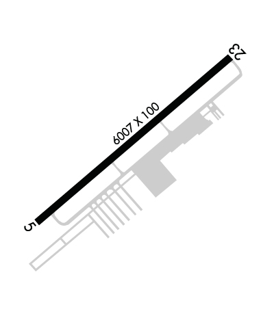
Runway Identifications
Runway Identification: 05/23
Length: 6007 ft
Width: 100 ft
Surface: ASPHALT-GOOD CONDITION
Edge lights: High Intensity

Treatment: GROOVED

 Runway: 05   Runway: 23
Mag heading: 53°Mag heading: 233°
Rwy Slope: .00% UpRwy Slope: .00% Down
Approach: ILS/DMEApproach:
Pattern: Left TrafficPattern: Left Traffic
Markings: PRECISION INSTRUMENTMarkings: NONPRECISION INSTRUMENT
Marking Condition: GOODMarking Condition: GOOD
Arresting Dev: Arresting Dev:
Lat & Long: N3318.4  W08656.0Lat. & Long.: N3319.1  W08655.1
Elev: 699.3 ft. MSLElev: 699.5 ft. MSL
TCH: 60 ft. AGLTCH: 40 ft. AGL
Visual Glide Path: 3.00 degreesVisual Glide Path: 3.00 degrees
Displaced Threshold: NoDisplaced Threshold: No
Touchdown Zone: YESTouchdown Zone: YES
Touchdown Elev.: 699.5 feetTouchdown Elev.: 699.6 feet
Visual Glide Slope: 4-Light PAPI on LEFT side of RunwayVisual Glide Slope: 4-Light PAPI on LEFT side of Runway
RVR Equipment: RVR Equipment:
RVV Equipment: NORVV Equipment: NO
Approach Lights: Approach Lights:
REIL: YESREIL: YES
Centerline Lights: NOCenterline Lights: NO
Touchdown lights: NOTouchdown lights: NO
Runway Category: Precision Instrument RunwayRunway Category: Runway with a Non-precision Approach having visibility minimums greater than 3/4 mile
Declared Distances: Declared Distances:
Obstructions: TREESObstructions: TREES
Marked: NOT Marked/LightedMarked: NOT Marked/Lighted
Clearance slope: 6:1Clearance slope: 4:1
Obstruction height: 41 feet AGLObstruction height: 31 feet AGL
Dist. from runway: 472 feetDist. from runway: 339 feet
Centerline offset: 433 right of centerlineCenterline offset: 179 feet right of centerline
Comments: Comments:
C:40/P: