Click here for more info on on SMS!

KEKQ

WAYNE COUNTY
MONTICELLO
KY
Time Zone: Eastern
Lat: N 3651.3
Long: W 08451.4
Elev: 963
Var: +03
Longest Runway: 4000
AWOS: 118.82
CTAF: 122.8

FBO & Flight Services info for KEKQ

FBOs: Update your Fuel Prices

WAYNE COUNTY ARPTPh: 606-348-7700 Fax: N/A Freq: 122.8
Service
Jet
100LL
SAF
MoGas
Fuel Avail: ASSISTED SELF SERVE
Full        Last Update: 04/15/2024 11:35

Self5.155.25    
 Address: 519 AIRPORT RD   MONTICELLO, KY 42633
ASOSPh: 606-348-0862
-
Freq: 118.82  
If you are an FBO, call 1-203-262-1700 to update your info or email: FltPlan.Advertising@garmin.com
Advertise your FBO on FltPlan.com

Runway & Approach Info for KEKQ
Rwy
Length
Land Dist**
Approach*
  Rwy
Length
Land Dist**
Approach*
03
4000x75  4000'          
 
  
21
  4000x75  4000'          
 
 * only ILS, LOC, LDA, and SDF approaches to a specific runway are shown
** For any Declared Landing Distance Available, please see A/FD or Approach plates
Runway Weight Capability (lbs.) Help
Runway IDSingle WheelDouble WheelDouble Tandem WheelDual Double Wheel
03/2112,500N/AN/AN/A
These numbers are Advisory and are not limits.   The Airport Manager should have more accurate Weight Limits
Approach Charts
Approaches    
Current Weather/Notams
Customs Information Send updates to Support@FltPlan.com
Customs Not Available
Database effective 04/18/2024
Airport Diagram of KEKQ
Airport Diagram might not be current.

Facility Name: WAYNE COUNTY
City Name: MONTICELLO
County: WAYNE
State abbrev: KY
State Name: KENTUCKY
   
Ownership: PUBLICLY OWNED
Use: OPEN TO THE PUBLIC
Owner's Name: WAYNE CO ARPT BOARD
Address: P.O. BOX 439
 MONTICELLO, KY 42633
Owner's Phone: 606-348-4241; 606-348-4241
  
Manager's Name: JERRY HAMPTON
Address: 519 AIRPORT ROAD
 MONTICELLO, KY 42633
Phone: (661) 205-6415
   
FAA Region: SOUTHERN
FAA Field Office: MEM


Sunrise / Sunset times for WAYNE COUNTY

DateSunriseSunset
04/15/24 Monday7:0420:15
04/16/24 Tuesday7:0320:16
04/17/24 Wednesday7:0220:17
04/18/24 Thursday7:0020:17
04/19/24 Friday6:5920:18
04/20/24 Saturday6:5820:19
04/21/24 Sunday6:5620:20
04/22/24 Monday6:5520:21
04/23/24 Tuesday6:5420:22
04/24/24 Wednesday6:5320:23
04/25/24 Thursday6:5120:24
04/26/24 Friday6:5020:24
04/27/24 Saturday6:4920:25
04/28/24 Sunday6:4820:26

Airport Facilities

Airport Attendance ScheduleMON-SAT 0830-1730, SUN UNATNDD
Airport Status OPERATIONAL (This Status can change at any time - please check NOTAMS)
Airport Lighting ScheduleACTVT REIL RWY 21; PAPI RWY 03/21; MIRL RWY 03/21 - CTAF. LTG PRESET LOW INTST; INCR INTST - CTAF.
Airport Storage AvailableTie Downs, Hanger
Extra Services AvailableAir Ambulance
Wind IndicatorYES - (lighted)
Control TowerNO
CTAF Frequency122.800
Unicom Frequency122.800
Rotating Beacon ColorWG
Segmented CircleYES
Landing FeeNO

Airport Inspection Data

Airport InspectedSTATE - performed by STATE AERONAUTICAL PERSONNEL
Inspection Date04/13/2021

Airport Services

Type of Fuel AvailableGrade 100LL, JET A; -10FUEL AVBL 24/7 WITH CC.
Airframe Repair ServiceNONE
Power Plant Repair ServiceNONE

Geographic Data

LatitudeN3651.3
LongitudeW08451.4 (ESTIMATED)
Arpt Elevation962ft (SURVEYED)
Magnetic Variation03W
2 miles Nof MONTICELLO
Traffic Pattern Altitude
Sectional ChartCINCINNATI

Aircraft Data

Operations (Reported)YearlyAvg. Daily
General Aviation Transient 480013
General Aviation Local 29008
Air Taxi 7602
Commerical 00
Commuter 00
Military 1800
Aircraft based on Field
General Aviation Singles 9
General Aviation Multi 1
Jet Aircraft 0
General Aviation Helicopters 0
Military Aircraft 0
Gliders 0
Ultralights 0

FAA Services

FSS on field NO
FSS tie-in LOUISVILLE
FSS Phone 1-800-WX-BRIEF
Who issues Notams LOU
Notam D service at airport YES
ARTCC Name INDIANAPOLIS

Federal Status

Airport Certification
Aircraft Rescue & Firefighting IndexNone
Airport of EntryNo
Custom Landing RightsNo
Joint Civil/MilitaryNo
Military Landing rightsYES

Federal Agreements

NATIONAL PLAN OF INTEGRATED AIRPORT SYSTEMS (NPIAS)
GRANT AGREEMENTS UNDER FAAP/ADAP/AIP
ASSURANCES PURSUANT TO TITLE VI, CIVIL RIGHTS ACT OF 1964

Remarks

FOR CD CTC INDIANAPOLIS ARTCC AT 317-247-2411.
Airport Communications & Frequencies:
CTAF Frequency:
122.800
Unicom Frequency:
122.800
Remarks
  • APCH/DEP SVC PRVDD BY INDIANAPOLIS ARTCC ON FREQS 124.625/371.925 (LONDON 2 RCAG).
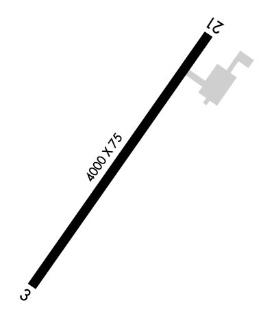
  • Runway Identifications
    Runway Identification: 03/21
    Length: 4000 ft
    Width: 75 ft
    Surface: ASPHALT-GOOD CONDITION
    Edge lights: Medium Intensity

    Treatment: NONE

     Runway: 03   Runway: 21
    Mag heading: 39°Mag heading: 219°
    Rwy Slope: .10% UpRwy Slope: -.10% Down
    Approach: Approach:
    Pattern: Left TrafficPattern: Left Traffic
    Markings: NONPRECISION INSTRUMENTMarkings: NONPRECISION INSTRUMENT
    Marking Condition: POOR; FADED & ALGAE COVEREDMarking Condition: POOR; FADED & ALGAE COVERED
    Arresting Dev: Arresting Dev:
    Lat & Long: N3651.0  W08451.6Lat. & Long.: N3651.6  W08451.1
    Elev: 958.6 ft. MSLElev: 962.5 ft. MSL
    TCH: 40 ft. AGLTCH: 40 ft. AGL
    Visual Glide Path: 3.00 degreesVisual Glide Path: 3.00 degrees
    Displaced Threshold: NoDisplaced Threshold: No
    Touchdown Zone: YESTouchdown Zone: YES
    Touchdown Elev.: 961.2 feetTouchdown Elev.: 962.6 feet
    Visual Glide Slope: 4-Light PAPI on LEFT side of RunwayVisual Glide Slope: 4-Light PAPI on LEFT side of Runway
    RVR Equipment: RVR Equipment:
    RVV Equipment: NORVV Equipment: NO
    Approach Lights: Approach Lights:
    REIL: YESREIL: YES
    Centerline Lights: NOCenterline Lights: NO
    Touchdown lights: NOTouchdown lights: NO
    Runway Category: Runway with a Non-precision ApproachRunway Category: Runway with a Non-precision Approach
    Declared Distances: Declared Distances:
    Obstructions: FENCEObstructions: TREE
    Marked: NOT Marked/LightedMarked: NOT Marked/Lighted
    Clearance slope: Clearance slope: 14:1
    Obstruction height: 23 feet AGLObstruction height: 119 feet AGL
    Dist. from runway: 201 feetDist. from runway: 1971 feet
    Centerline offset: 250 left of centerlineCenterline offset: 477 feet right of centerline
    Comments: FENCE 249.5 FT L PARALLEL TO RWY.Comments:
    C:1/P: