Current Weather/Notams (Metars, TAFs, Notams, NWS Forecast, PIREPS, and nearby weather)
Customs Information Send updates to Support@FltPlan.com
Customs Not Available
Database effective 04/18/2024
Airport Diagram might not be current.
|
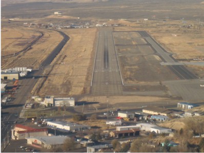
| Facility Name: | ELKO RGNL |
| City Name: | ELKO |
| County: | ELKO |
| State abbrev: | NV |
| State Name: | NEVADA |
| | |
| Ownership: | PUBLICLY OWNED |
| Use: | OPEN TO THE PUBLIC |
| Owner's Name: | CITY OF ELKO |
| Address: | 975 TERMINAL WAY |
| | ELKO, NV 89801 |
| Owner's Phone: | 775-777-7190 |
| | |
| Manager's Name: | JAMES FOSTER |
| Address: | 975 TERMINAL WAY |
| | ELKO, NV 89801 |
| Phone: | 775-777-7194 |
| | |
| FAA Region: | WESTERN-PACIFIC |
| FAA Field Office: | PHX |
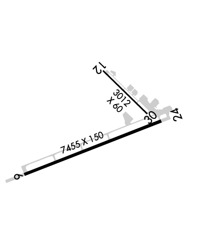
Runway Identifications
Runway Identification: 06/24Length: 7454 ft
Width: 150 ft
Surface: ASPHALT-GOOD CONDITION
Edge lights: Medium IntensityTreatment: GROOVED
Weight: PCN 63 /F/B/X/T
| | Runway: 06 | | Runway: 24 |
| Mag heading: | 57° | Mag heading: | 237° |
| Rwy Slope: | .27% Up | Rwy Slope: | -.27% Down |
| Approach: | | Approach: | LDA/DME |
| Pattern: | Right Traffic | Pattern: | Left Traffic |
| Markings: | PRECISION INSTRUMENT | Markings: | PRECISION INSTRUMENT |
| Marking Condition: | GOOD | Marking Condition: | GOOD |
| Arresting Dev: | | Arresting Dev: | |
| Lat & Long: | N4049.1 W11548.3 | Lat. & Long.: | N4049.6 W11546.8 |
| Elev: | 5051.1 ft. MSL | Elev: | 5071.1 ft. MSL |
| TCH: | 44 ft. AGL | TCH: | 51 ft. AGL |
| Visual Glide Path: | 3.00 degrees | Visual Glide Path: | 3.25 degrees |
| Displaced Threshold: | No | Displaced Threshold: | 1036 feet |
| Touchdown Zone: | YES | Touchdown Zone: | YES |
| Touchdown Elev.: | 5051.1 feet | Touchdown Elev.: | 5063.8 feet |
| Visual Glide Slope: | 4-Light PAPI on LEFT side of Runway | Visual Glide Slope: | 4-Light PAPI on LEFT side of Runway; PAPI RWY 24 DOES NOT PRVD OBSTN CLNC BYD 6.5 NM FM THR. |
| RVR Equipment: | | RVR Equipment: | |
| RVV Equipment: | NO | RVV Equipment: | NO |
| Approach Lights: | | Approach Lights: | MALSR - 1,400 foot medium intensity approach lighting system with runway alignment indicator lights |
| REIL: | NO | REIL: | NO |
| Centerline Lights: | NO | Centerline Lights: | NO |
| Touchdown lights: | NO | Touchdown lights: | NO |
| Runway Category: | Runway with a Non-precision Approach having visibility minimums greater than 3/4 mile | Runway Category: | D |
| Declared Distances: | TORA:7217' TODA:7217' ASDA:7217' LDA:7217' | Declared Distances: | TORA:7451' TODA:7451' ASDA:7451' LDA:6416' |
| Obstructions: | ROAD | Obstructions: | POLE |
| Marked: | NOT Marked/Lighted | Marked: | NOT Marked/Lighted |
| Clearance slope: | 20:1 | Clearance slope: | 21:1 |
| Obstruction height: | 24 feet AGL | Obstruction height: | 99 feet AGL |
| Dist. from runway: | 700 feet | Dist. from runway: | 2300 feet |
| Centerline offset: | 325 right of centerline | Centerline offset: | 450 feet right of centerline |
| Comments: | | Comments: | |
Runway Identification: 12/30Length: 3015 ft
Width: 60 ft
Surface: ASPHALT-GOOD CONDITION
Edge lights: Treatment: NONE
Weight: PCN 4 /F/B/Y/T
| | Runway: 12 | | Runway: 30 |
| Mag heading: | 122° | Mag heading: | 302° |
| Rwy Slope: | -1.98% Down | Rwy Slope: | 1.98% Up |
| Approach: | | Approach: | |
| Pattern: | Right Traffic | Pattern: | Left Traffic |
| Markings: | BASIC | Markings: | BASIC |
| Marking Condition: | GOOD | Marking Condition: | GOOD |
| Arresting Dev: | | Arresting Dev: | |
| Lat & Long: | N4050.0 W11547.5 | Lat. & Long.: | N4049.7 W11547.0 |
| Elev: | 5139.8 ft. MSL | Elev: | 5080.0 ft. MSL |
| TCH: | | TCH: | |
| Visual Glide Path: | | Visual Glide Path: | |
| Displaced Threshold: | 906 feet | Displaced Threshold: | 143 feet |
| Touchdown Zone: | YES | Touchdown Zone: | YES |
| Touchdown Elev.: | 5124.8 feet | Touchdown Elev.: | 5139.8 feet |
| Visual Glide Slope: | | Visual Glide Slope: | |
| RVR Equipment: | | RVR Equipment: | |
| RVV Equipment: | NO | RVV Equipment: | NO |
| Approach Lights: | | Approach Lights: | |
| REIL: | NO | REIL: | NO |
| Centerline Lights: | NO | Centerline Lights: | NO |
| Touchdown lights: | NO | Touchdown lights: | NO |
| Runway Category: | Runway with a Visual Approach | Runway Category: | Runway with a Visual Approach |
| Declared Distances: | TORA:3012' TODA:3012' ASDA:3012' LDA:2106' | Declared Distances: | TORA:3012' TODA:3012' ASDA:3012' LDA:2871' |
| Obstructions: | POLE | Obstructions: | POLE |
| Marked: | MARKED | Marked: | NOT Marked/Lighted |
| Clearance slope: | 17:1 | Clearance slope: | 23:1 |
| Obstruction height: | 26 feet AGL | Obstruction height: | 30 feet AGL |
| Dist. from runway: | 650 feet | Dist. from runway: | 900 feet |
| Centerline offset: | 75 left of centerline | Centerline offset: | 100 feet left of centerline |
| Comments: | | Comments: | |