Current Weather/Notams (Metars, TAFs, Notams, NWS Forecast, PIREPS, and nearby weather)
Customs Information Send updates to Support@FltPlan.com
Customs Not Available
Database effective 04/18/2024
Airport Diagram might not be current. Facility Name: ELKINS/RANDOLPH COUNTY (JENNINGS RANDOLPH FLD) City Name: ELKINS County: RANDOLPH State abbrev: WV State Name: WEST VIRGINIA Ownership: PUBLICLY OWNED Use: OPEN TO THE PUBLIC Owner's Name: ELKINS-RANDOLPH CO RGNL ARPT AUTH Address: 400 AIRPORT RD ELKINS, WV 26241 Owner's Phone: 304-636-2726 Manager's Name: MARY ALICE RICOTTILLI Address: 400 AIRPORT RD ELKINS, WV 26241 Phone: 304-636-2726 FAA Region: EASTERN FAA Field Office: BKW
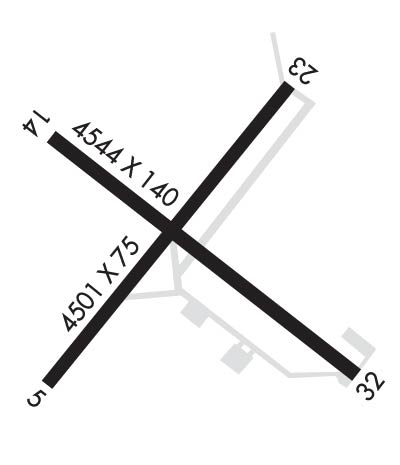
Runway Identifications Help
Runway Identification: 05/23 Length: 4501 ftWidth: 75 ftSurface: ASPHALT-FAIR CONDITIONEdge lights: Medium Intensity Treatment: NONE Runway: 05 Runway: 23 Mag heading: 46° Mag heading: 226° Rwy Slope: -.59% Down Rwy Slope: .59% Up Approach: Approach: Pattern: Left Traffic Pattern: Left Traffic Markings: NONPRECISION INSTRUMENT Markings: NONPRECISION INSTRUMENT Marking Condition: FAIR Marking Condition: FAIR Arresting Dev: Arresting Dev: Lat & Long: N3853.1 W07951.8 Lat. & Long.: N3853.7 W07951.2 Elev: 1973.5 ft. MSL Elev: 1947.0 ft. MSL TCH: TCH: 45 ft. AGL Visual Glide Path: Visual Glide Path: 5.00 degrees Displaced Threshold: 154 feet Displaced Threshold: No Touchdown Zone: YES Touchdown Zone: YES Touchdown Elev.: 1971.8 feet Touchdown Elev.: 1958.2 feet Visual Glide Slope: Visual Glide Slope: 2-Light PAPI on LEFT side of Runway; PAPI NON-STD 5 DEG GA. RVR Equipment: RVR Equipment: RVV Equipment: NO RVV Equipment: NO Approach Lights: Approach Lights: REIL: NO REIL: YES ; OMNI-DIRECTIONAL REIL.Centerline Lights: NO Centerline Lights: NO Touchdown lights: NO Touchdown lights: NO Runway Category: Runway with a Non-precision Approach having visibility minimums greater than 3/4 mile Runway Category: Runway with a Non-precision Approach having visibility minimums greater than 3/4 mile Declared Distances: Declared Distances: Obstructions: TREES Obstructions: ANT Marked: NOT Marked/Lighted Marked: LIGHTED Clearance slope: 86 FT ANTENNA, 850 FM RWY END APCH SLOPE 11:1 TO DSPLCD THR. Clearance slope: 7:1 Obstruction height: 40 feet AGL Obstruction height: 258 feet AGL Dist. from runway: 201 feet Dist. from runway: 2135 feet Centerline offset: 150 right of centerline Centerline offset: 480 feet right of centerline Comments: 30 FT TREES, 170 FT DSTC. Comments:
Runway Identification: 14/32 Length: 4544 ftWidth: 140 ftSurface: ASPHALT-GOOD CONDITIONEdge lights: Treatment: NONE Runway: 14 Runway: 32 Mag heading: 136° Mag heading: 316° Rwy Slope: 1.03% Up Rwy Slope: -1.03% Down Approach: Approach: Pattern: Left Traffic Pattern: Left Traffic Markings: BASIC Markings: BASIC Marking Condition: FAIR Marking Condition: FAIR Arresting Dev: Arresting Dev: Lat & Long: N3853.6 W07951.8 Lat. & Long.: N3853.1 W07951.0 Elev: 1940.0 ft. MSL Elev: 1987.0 ft. MSL TCH: TCH: Visual Glide Path: Visual Glide Path: Displaced Threshold: No Displaced Threshold: 1390 feet Touchdown Zone: YES Touchdown Zone: YES Touchdown Elev.: 1968.3 feet Touchdown Elev.: 1969.7 feet Visual Glide Slope: Visual Glide Slope: RVR Equipment: RVR Equipment: RVV Equipment: NO RVV Equipment: NO Approach Lights: Approach Lights: REIL: NO REIL: NO Centerline Lights: NO Centerline Lights: NO Touchdown lights: NO Touchdown lights: NO Runway Category: Runway with a Non-precision Approach having visibility minimums greater than 3/4 mile Runway Category: Runway with a Visual Approach Declared Distances: Declared Distances: Obstructions: TREE Obstructions: TREES Marked: NOT Marked/Lighted Marked: NOT Marked/Lighted Clearance slope: 8:1 Clearance slope: APCH SLOPE 9:1 AT DSPLCD THR OVR 156 FT TREE, 1500 FT DSTC, 220 FT L. Obstruction height: 62 feet AGL Obstruction height: 80 feet AGL Dist. from runway: 700 feet Dist. from runway: 280 feet Centerline offset: 175 right of centerline Centerline offset: 100 feet right of centerline Comments: Comments: 156 FT TREES, 110 FT DSTC, 220 FT L.