Click here for more info on on SMS!

KEKA

Whisper PlateWhisper Track
MURRAY FIELD
EUREKA
CA
Time Zone: Pacific
Lat: N 4048.2
Long: W 12406.8
Elev: 11
Var: -15
Longest Runway: 3011
CTAF: 122.7

FBO & Flight Services info for KEKA

FBOs: Update your Fuel Prices

NORTHERN AIRPh: 707-443-3179
-
Freq: 122.7
Service
Jet
100LL
SAF
MoGas
Fuel Avail: ~~NO FUEL AVAILABLE
Full        Last Update: 04/19/2024 00:01:44

Self        
 Address: 4102 JACOBS,   EUREKA, CA 95501
If you are an FBO, call 1-203-262-1700 to update your info or email: FltPlan.Advertising@garmin.com
Advertise your FBO on FltPlan.com

Runway & Approach Info for KEKA
Rwy
Length
Land Dist**
Approach*
  Rwy
Length
Land Dist**
Approach*
12
3011x75  3011'          
 
  
30
  3011x75  3011'          
 
 * only ILS, LOC, LDA, and SDF approaches to a specific runway are shown
** For any Declared Landing Distance Available, please see A/FD or Approach plates
Runway Weight Capability (lbs.) Help
Runway IDSingle WheelDouble WheelDouble Tandem WheelDual Double Wheel
12/3019,000N/AN/AN/A
These numbers are Advisory and are not limits.   The Airport Manager should have more accurate Weight Limits
Approach Charts
Approaches    
Current Weather/Notams
Customs Information Send updates to Support@FltPlan.com
Phone 707-442-4822
Fax 707-442-0152

Comments Mon-Fri 083-1630 *Maximum passengers per flight: 10 *Call prior to 1700 on preceding weekday *Call prior to 1700 on preceding Friday for weekend service and Holidays.
Database effective 04/18/2024
Airport Diagram of KEKA
Airport Diagram might not be current.

Facility Name: MURRAY FLD
City Name: EUREKA
County: HUMBOLDT
State abbrev: CA
State Name: CALIFORNIA
   
Ownership: PUBLICLY OWNED
Use: OPEN TO THE PUBLIC
Owner's Name: HUMBOLDT COUNTY
Address: 1106 2ND ST
 EUREKA, CA 95501
Owner's Phone: (707) 839-5401
  
Manager's Name: CODY ROGGATZ; AIRPORT MANAGER LOCATED AT ARCATA/EUREKA AIRPORT.
Address: 3561 BOEING AVE.
 MCKINLEYVILLE, CA 95519
Phone: (707) 839-5402
   
FAA Region: WESTERN-PACIFIC
FAA Field Office: SFO


Sunrise / Sunset times for MURRAY FLD

DateSunriseSunset
04/19/24 Friday6:3020:01
04/20/24 Saturday6:2920:02
04/21/24 Sunday6:2720:03
04/22/24 Monday6:2620:04
04/23/24 Tuesday6:2520:05
04/24/24 Wednesday6:2320:06
04/25/24 Thursday6:2220:07
04/26/24 Friday6:2020:09
04/27/24 Saturday6:1920:10
04/28/24 Sunday6:1820:11
04/29/24 Monday6:1620:12
04/30/24 Tuesday6:1520:13
05/01/24 Wednesday6:1420:14
05/02/24 Thursday6:1320:15

Airport Facilities

Airport Attendance ScheduleUNATTENDED
Airport Status OPERATIONAL (This Status can change at any time - please check NOTAMS)
Airport Lighting ScheduleACTVT VASI RWY 30; MIRL RWY 12/30 - CTAF.
Airport Storage AvailableTie Downs
Extra Services AvailableAir Freight, Charter, Flight Instruction
Wind IndicatorYES - (lighted)
Control TowerNO
CTAF Frequency122.700
Unicom Frequency122.700
Rotating Beacon ColorWG
Segmented CircleYES
Landing FeeNO

Airport Inspection Data

Airport InspectedSTATE - performed by STATE AERONAUTICAL PERSONNEL
Inspection Date11/28/2023

Airport Services

Type of Fuel AvailableGrade 100LL
Airframe Repair ServiceMAJOR
Power Plant Repair ServiceMAJOR

Geographic Data

LatitudeN4048.2
LongitudeW12406.8 (ESTIMATED)
Arpt Elevation10ft (SURVEYED)
Magnetic Variation15E
3 miles Eof EUREKA
Traffic Pattern Altitude800
Sectional ChartKLAMATH FALLS

Aircraft Data

Operations (Reported)YearlyAvg. Daily
General Aviation Transient 2000055
General Aviation Local 3500096
Air Taxi 1500
Commerical 00
Commuter 00
Military 3001
Aircraft based on Field
General Aviation Singles 38
General Aviation Multi 1
Jet Aircraft 0
General Aviation Helicopters 0
Military Aircraft 0
Gliders 0
Ultralights 0

FAA Services

FSS on field NO
FSS tie-in OAKLAND
FSS Phone 1-800-WX-BRIEF
Who issues Notams OAK
Notam D service at airport YES
ARTCC Name SEATTLE

Federal Status

Airport Certification
Aircraft Rescue & Firefighting IndexNone
Airport of EntryNo
Custom Landing RightsNo
Joint Civil/MilitaryNo
Military Landing rightsYES

Federal Agreements

NATIONAL PLAN OF INTEGRATED AIRPORT SYSTEMS (NPIAS)
GRANT AGREEMENTS UNDER FAAP/ADAP/AIP
ASSURANCES PURSUANT TO TITLE VI, CIVIL RIGHTS ACT OF 1964

Remarks

BE ALERT FOR BIRDS INVOF ARPT.
BE AWARE; CTAF FREQ SHARED WITH NEARBY ARPT.
FOR CD CTC SEATTLE ARTCC AT 253-351-3694.
DEER IN VCNTY OF RWY.
Airport Communications & Frequencies:
CTAF Frequency:
122.700
Unicom Frequency:
122.700
Remarks
  • APCH/DEP CTL SVC PRVDD BY SEATTLE ARTCC (ZSE) ON FREQS 124.85/306.3 (ARCATA RCAG).
  • Runway Identifications
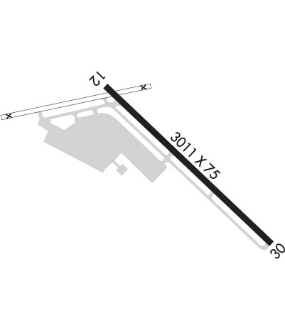
    Runway Identification: 12/30
    Length: 3011 ft
    Width: 75 ft
    Surface: ASPHALT-GOOD CONDITION
    Edge lights: Medium Intensity

    Treatment: NONE

     Runway: 12   Runway: 30
    Mag heading: 120°Mag heading: 300°
    Rwy Slope: .15% UpRwy Slope: -.15% Down
    Approach: Approach:
    Pattern: Left TrafficPattern: Right Traffic
    Markings: NONPRECISION INSTRUMENTMarkings: BASIC
    Marking Condition: GOODMarking Condition: GOOD
    Arresting Dev: Arresting Dev:
    Lat & Long: N4048.4  W12407.0Lat. & Long.: N4048.0  W12406.5
    Elev: 6.2 ft. MSLElev: 10.7 ft. MSL
    TCH: TCH: 26 ft. AGL
    Visual Glide Path: Visual Glide Path: 4.00 degrees
    Displaced Threshold: NoDisplaced Threshold: No
    Touchdown Zone: YESTouchdown Zone: YES
    Touchdown Elev.: 10.9 feetTouchdown Elev.: 10.9 feet
    Visual Glide Slope: Visual Glide Slope: 2-Box VASI on LEFT side of Runway; UNUSBL BYD 6.5 NM DUE TO TRRN.
    RVR Equipment: RVR Equipment:
    RVV Equipment: NORVV Equipment: NO
    Approach Lights: Approach Lights:
    REIL: NOREIL: NO
    Centerline Lights: NOCenterline Lights: NO
    Touchdown lights: NOTouchdown lights: NO
    Runway Category: Runway with a Non-precision ApproachRunway Category: Runway with a Visual Approach
    Declared Distances: Declared Distances:
    C:1/P: