Current Weather/Notams (Metars, TAFs, Notams, NWS Forecast, PIREPS, and nearby weather)
Customs Information Send updates to Support@FltPlan.com
Customs Not Available
Database effective 05/16/2024
Airport Diagram might not be current.
|
| Facility Name: | ELKHART-MORTON COUNTY |
| City Name: | ELKHART |
| County: | MORTON |
| State abbrev: | KS |
| State Name: | KANSAS |
| | |
| Ownership: | PUBLICLY OWNED |
| Use: | OPEN TO THE PUBLIC |
| Owner's Name: | MORTON COUNTY |
| Address: | P.O. BOX 1116 |
| | ELKHART, KS 67950 |
| Owner's Phone: | 620-697-2157 |
| | |
| Manager's Name: | DENNIS TEVEBAUGH |
| Address: | PO BOX 392 |
| | ELKHART, KS 67950 |
| Phone: | (620) 360-6100; CELL PHONE # 620-360-3600. |
| | |
| FAA Region: | CENTRAL |
| FAA Field Office: | NONE |
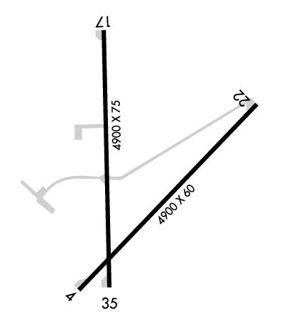
Runway Identifications
Runway Identification: 04/22Length: 4900 ft
Width: 60 ft
Surface: ASPHALT-FAIR CONDITION
Edge lights: Medium IntensityTreatment: NONE
Weight: PCN 5 /F/C/Y/U
| | Runway: 04 | | Runway: 22 |
| Mag heading: | 41° | Mag heading: | 221° |
| Rwy Slope: | -.57% Down | Rwy Slope: | .57% Up |
| Approach: | | Approach: | |
| Pattern: | Right Traffic | Pattern: | Left Traffic |
| Markings: | NONPRECISION INSTRUMENT | Markings: | NONPRECISION INSTRUMENT |
| Marking Condition: | GOOD | Marking Condition: | GOOD |
| Arresting Dev: | | Arresting Dev: | |
| Lat & Long: | N3659.7 W10153.1 | Lat. & Long.: | N3700.2 W10152.3 |
| Elev: | 3621.8 ft. MSL | Elev: | 3594.1 ft. MSL |
| TCH: | 38 ft. AGL | TCH: | 39 ft. AGL |
| Visual Glide Path: | 3.00 degrees | Visual Glide Path: | 3.00 degrees |
| Displaced Threshold: | No | Displaced Threshold: | No |
| Touchdown Zone: | YES | Touchdown Zone: | YES |
| Touchdown Elev.: | 3621.9 feet | Touchdown Elev.: | 3614.5 feet |
| Visual Glide Slope: | 4-Light PAPI on LEFT side of Runway | Visual Glide Slope: | 4-Light PAPI on LEFT side of Runway |
| RVR Equipment: | | RVR Equipment: | |
| RVV Equipment: | NO | RVV Equipment: | NO |
| Approach Lights: | | Approach Lights: | |
| REIL: | NO | REIL: | NO |
| Centerline Lights: | NO | Centerline Lights: | NO |
| Touchdown lights: | NO | Touchdown lights: | NO |
| Runway Category: | Runway with a Non-precision Approach | Runway Category: | Runway with a Non-precision Approach |
| Declared Distances: | | Declared Distances: | |
| Obstructions: | ROAD | Obstructions: | TOWER; PIVOT IRRIGATION TWR (MOVING WHEN IN OPN). |
| Marked: | NOT Marked/Lighted | Marked: | NOT Marked/Lighted |
| Clearance slope: | 23:1 | Clearance slope: | 3:1 |
| Obstruction height: | 15 feet AGL | Obstruction height: | 21 feet AGL |
| Dist. from runway: | 546 feet | Dist. from runway: | 279 feet |
| Centerline offset: | | Centerline offset: | |
| Comments: | | Comments: | |
Runway Identification: 17/35Length: 4907 ft
Width: 75 ft
Surface: CONCRETE
Edge lights: Medium IntensityTreatment: NONE
Weight: PCN 11 /R/C/X/U
| | Runway: 17 | | Runway: 35 |
| Mag heading: | 172° | Mag heading: | 352° |
| Rwy Slope: | .20% Up | Rwy Slope: | -.20% Down |
| Approach: | | Approach: | |
| Pattern: | Left Traffic | Pattern: | Right Traffic |
| Markings: | NONPRECISION INSTRUMENT | Markings: | NONPRECISION INSTRUMENT |
| Marking Condition: | GOOD | Marking Condition: | GOOD |
| Arresting Dev: | | Arresting Dev: | |
| Lat & Long: | N3700.5 W10152.9 | Lat. & Long.: | N3659.7 W10152.9 |
| Elev: | 3607.6 ft. MSL | Elev: | 3617.6 ft. MSL |
| TCH: | 40 ft. AGL | TCH: | 44 ft. AGL |
| Visual Glide Path: | 3.00 degrees | Visual Glide Path: | 3.00 degrees |
| Displaced Threshold: | No | Displaced Threshold: | No |
| Touchdown Zone: | YES | Touchdown Zone: | YES |
| Touchdown Elev.: | 3618.7 feet | Touchdown Elev.: | 3618.9 feet |
| Visual Glide Slope: | 4-Light PAPI on LEFT side of Runway | Visual Glide Slope: | 4-Light PAPI on LEFT side of Runway |
| RVR Equipment: | | RVR Equipment: | |
| RVV Equipment: | NO | RVV Equipment: | NO |
| Approach Lights: | | Approach Lights: | |
| REIL: | NO | REIL: | NO |
| Centerline Lights: | NO | Centerline Lights: | NO |
| Touchdown lights: | NO | Touchdown lights: | NO |
| Runway Category: | Runway with a Non-precision Approach having visibility minimums greater than 3/4 mile | Runway Category: | Runway with a Non-precision Approach having visibility minimums greater than 3/4 mile |
| Declared Distances: | | Declared Distances: | |
| Obstructions: | POLE | Obstructions: | ROAD |
| Marked: | NOT Marked/Lighted | Marked: | NOT Marked/Lighted |
| Clearance slope: | 39:1 | Clearance slope: | 20:1 |
| Obstruction height: | 18 feet AGL | Obstruction height: | 15 feet AGL |
| Dist. from runway: | 917 feet | Dist. from runway: | 506 feet |
| Centerline offset: | 100 right of centerline | Centerline offset: | |
| Comments: | | Comments: | |

