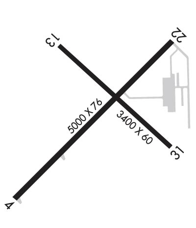
Click here for more info on on SMS!

KEGV

EAGLE RIVER UNION
EAGLE RIVER
WI
Time Zone: Central
Lat: N 4555.9
Long: W 08916.1
Elev: 1642
Var: +02
Longest Runway: 5000
AWOS: 118.32
CTAF: 122.8

FBO & Flight Services info for KEGV

FBOs: Update your Fuel Prices

EAGLE RIVER ARPTPh: 715-479-7442 Fax: 715-479-1868 Freq: 122.8
Service
Jet
100LL
SAF
MoGas
Fuel Avail: 8:30 - 5pm 7 days, call out fee for after hours
Full6.006.20    Caution: Fuel prices have not been updated in 34 days.
Last Update: 03/15/2024 09:30

Self5.505.70    
 Address: 1311 AIRPORT RD,   EAGLE RIVER, WI 54521
AWOSPh: 715-479-1465
-
Freq: 118.32  
If you are an FBO, call 1-203-262-1700 to update your info or email: FltPlan.Advertising@garmin.com
Advertise your FBO on FltPlan.com

Runway & Approach Info for KEGV
Rwy
Length
Land Dist**
Approach*
  Rwy
Length
Land Dist**
Approach*
04
5000x76  5000'          
LOC/DME
 110.70 - 047°  
  
22
  5000x76  5000'          
 
13
3400x60  3400'          
 
  
31
  3400x60  3400'          
 
 * only ILS, LOC, LDA, and SDF approaches to a specific runway are shown
** For any Declared Landing Distance Available, please see A/FD or Approach plates
Runway Weight Capability (lbs.) Help
Runway IDSingle WheelDouble WheelDouble Tandem WheelDual Double Wheel
04/2212,500N/AN/AN/A
13/31N/AN/AN/AN/A
H1N/AN/AN/AN/A
These numbers are Advisory and are not limits.   The Airport Manager should have more accurate Weight Limits
Approach Charts
Approaches    
Current Weather/Notams
Customs Information Send updates to Support@FltPlan.com
Customs Not Available
Database effective 04/18/2024
Airport Diagram of KEGV
Airport Diagram might not be current.

Facility Name: EAGLE RIVER UNION
City Name: EAGLE RIVER
County: VILAS
State abbrev: WI
State Name: WISCONSIN
   
Ownership: PUBLICLY OWNED
Use: OPEN TO THE PUBLIC
Owner's Name: CITY OF EAGLE RIVER
Address: PO BOX 2320
 EAGLE RIVER, WI 54521
Owner's Phone: 715-479-7442
  
Manager's Name: ROBERT HOM
Address: PO BOX 2320
 EAGLE RIVER, WI 54521
Phone: 715-479-7442
   
FAA Region: GREAT LAKES
FAA Field Office: CHI


Sunrise / Sunset times for EAGLE RIVER UNION

DateSunriseSunset
04/17/24 Wednesday6:0619:48
04/18/24 Thursday6:0419:49
04/19/24 Friday6:0319:50
04/20/24 Saturday6:0119:52
04/21/24 Sunday5:5919:53
04/22/24 Monday5:5719:54
04/23/24 Tuesday5:5619:56
04/24/24 Wednesday5:5419:57
04/25/24 Thursday5:5219:58
04/26/24 Friday5:5119:59
04/27/24 Saturday5:4920:01
04/28/24 Sunday5:4820:02
04/29/24 Monday5:4620:03
04/30/24 Tuesday5:4420:05

Airport Facilities

Airport Attendance Schedule7 Days A Week 0830-1700; FOR ATTENDANT OTR HRS CALL 715-479-7442.
Airport Status OPERATIONAL (This Status can change at any time - please check NOTAMS)
Airport Lighting ScheduleMIRL RWY 04/22 PRESET TO LOW SS-SR; ACTVT AND INCR INTST REIL RWY 4 & 22; PAPI RWY 4 & 22; MIRL RWY 13/31; PERI H1; TWY LGTS - CTAF.
Airport Storage AvailableTie Downs, Hanger
Extra Services AvailableNONE
Wind IndicatorYES - (lighted)
Control TowerNO
CTAF Frequency122.800
Unicom Frequency122.800
Rotating Beacon ColorWG
Segmented CircleYES
Landing FeeNO

Airport Inspection Data

Airport InspectedSTATE - performed by STATE AERONAUTICAL PERSONNEL
Inspection Date08/10/2023

Airport Services

Type of Fuel AvailableGrade 100LL, JET A; -1024 HR SELF SVC FUEL AVBL WITH CREDIT CARD.
Airframe Repair ServiceMAJOR
Power Plant Repair ServiceMAJOR

Geographic Data

LatitudeN4555.9
LongitudeW08916.1 (ESTIMATED)
Arpt Elevation1642ft (SURVEYED)
Magnetic Variation02W
0 miles NWof EAGLE RIVER
Traffic Pattern Altitude
Sectional ChartGREEN BAY

Aircraft Data

Operations (Reported)YearlyAvg. Daily
General Aviation Transient 560015
General Aviation Local 440012
Air Taxi 15004
Commerical 880
Commuter 00
Military 100
Aircraft based on Field
General Aviation Singles 35
General Aviation Multi 3
Jet Aircraft 1
General Aviation Helicopters 2
Military Aircraft 0
Gliders 0
Ultralights 0

FAA Services

FSS on field NO
FSS tie-in GREEN BAY
FSS Phone 1-800-WX-BRIEF
Who issues Notams EGV
Notam D service at airport YES
ARTCC Name MINNEAPOLIS

Federal Status

Airport Certification
Aircraft Rescue & Firefighting IndexNone
Airport of EntryNo
Custom Landing RightsNo
Joint Civil/MilitaryNo
Military Landing rightsYES

Federal Agreements

NATIONAL PLAN OF INTEGRATED AIRPORT SYSTEMS (NPIAS)
GRANT AGREEMENTS UNDER FAAP/ADAP/AIP
ASSURANCES PURSUANT TO TITLE VI, CIVIL RIGHTS ACT OF 1964

Remarks

FOR CD CTC MINNEAPOLIS ARTCC AT 651-463-5588.
Airport Communications & Frequencies:
CTAF Frequency:
122.800
Unicom Frequency:
122.800
Remarks
  • APCH/DEP SVC PRVDD BY MINNEAPOLIS ARTCC ON FREQS 133.65/281.5 (RHINELANDER RCAG).
  • Runway Identifications
    Runway Identification: 04/22
    Length: 5000 ft
    Width: 76 ft
    Surface: ASPHALT
    Edge lights: Medium Intensity

    Treatment: NONE
    Weight: PCN 23 /F/C/Y/T

     Runway: 04   Runway: 22
    Mag heading: 47°Mag heading: 227°
    Rwy Slope: -.07% DownRwy Slope: .07% Up
    Approach: LOC/DMEApproach:
    Pattern: Left TrafficPattern: Left Traffic
    Markings: NONPRECISION INSTRUMENTMarkings: NONPRECISION INSTRUMENT
    Marking Condition: GOODMarking Condition: GOOD
    Arresting Dev: Arresting Dev:
    Lat & Long: N4555.6  W08916.6Lat. & Long.: N4556.2  W08915.7
    Elev: 1640.7 ft. MSLElev: 1637.4 ft. MSL
    TCH: 45 ft. AGLTCH: 34 ft. AGL
    Visual Glide Path: 3.00 degreesVisual Glide Path: 3.00 degrees
    Displaced Threshold: NoDisplaced Threshold: No
    Touchdown Zone: YESTouchdown Zone: YES
    Touchdown Elev.: 1641.9 feetTouchdown Elev.: 1642.2 feet
    Visual Glide Slope: 4-Light PAPI on LEFT side of RunwayVisual Glide Slope: 4-Light PAPI on LEFT side of Runway
    RVR Equipment: RVR Equipment:
    RVV Equipment: NORVV Equipment: NO
    Approach Lights: Approach Lights:
    REIL: YESREIL: YES
    Centerline Lights: NOCenterline Lights: NO
    Touchdown lights: NOTouchdown lights: NO
    Runway Category: Runway with a Non-precision Approach having visibility minimums greater than 3/4 mileRunway Category: Runway with a Non-precision Approach having visibility minimums greater than 3/4 mile
    Declared Distances: Declared Distances:
    Obstructions: Obstructions: TREE
    Marked: Marked: NOT Marked/Lighted
    Clearance slope: 34:1Clearance slope: 31:1
    Obstruction height: Obstruction height: 80 feet AGL
    Dist. from runway: Dist. from runway: 2745 feet
    Centerline offset: Centerline offset: 110 feet left of centerline
    Comments: Comments:
    Runway Identification: 13/31
    Length: 3400 ft
    Width: 60 ft
    Surface: ASPHALT-FAIR CONDITION
    Edge lights: Medium Intensity

    Treatment: NONE

     Runway: 13   Runway: 31
    Mag heading: 134°Mag heading: 314°
    Rwy Slope: .00% UpRwy Slope: .00% Down
    Approach: Approach:
    Pattern: Left TrafficPattern: Left Traffic
    Markings: BASICMarkings: BASIC
    Marking Condition: FAIRMarking Condition: FAIR
    Arresting Dev: Arresting Dev:
    Lat & Long: N4556.2  W08916.3Lat. & Long.: N4555.8  W08915.7
    Elev: 1640.1 ft. MSLElev: 1640.2 ft. MSL
    TCH: TCH:
    Visual Glide Path: Visual Glide Path:
    Displaced Threshold: NoDisplaced Threshold: No
    Touchdown Zone: YESTouchdown Zone: YES
    Touchdown Elev.: 1642.2 feetTouchdown Elev.: 1642.2 feet
    Visual Glide Slope: Visual Glide Slope:
    RVR Equipment: RVR Equipment:
    RVV Equipment: NORVV Equipment: NO
    Approach Lights: Approach Lights:
    REIL: NOREIL: NO
    Centerline Lights: NOCenterline Lights: NO
    Touchdown lights: NOTouchdown lights: NO
    Runway Category: Runway with a Visual ApproachRunway Category: Runway with a Visual Approach
    Declared Distances: Declared Distances:
    Obstructions: TREESObstructions:
    Marked: NOT Marked/LightedMarked:
    Clearance slope: 8:1Clearance slope: 20:1
    Obstruction height: 15 feet AGLObstruction height:
    Dist. from runway: 325 feetDist. from runway:
    Centerline offset: 100 right of centerlineCenterline offset:
    Comments: Comments:
    Runway Identification: H1 HELIPAD
    Length: 60 ft
    Width: 60 ft
    Surface: CONCRETE
    Edge lights: PERI

    Treatment: NONE

    C:11/P: