| ||||||||||||||||||||||||||||||||||||||||||||
| ||||||||||||||||||||||||||||||||||||||||||||
| ||||||||||||||||||||||||||||||||||||||||||||
| FBOs at nearby airports who want your business: | |||||||||||||||||
| |||||||||||||||||
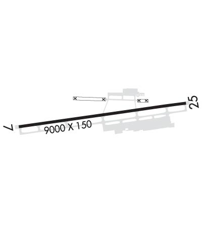
| Rwy | Rwy | |||||||
| 9000x150 | 9000' | 9000x150 | 8000' | 109.75 - 249° | ||||
| Runway ID | Single Wheel | Double Wheel | Double Tandem Wheel | Dual Double Wheel |
| 07/25 | 75,000 | 140,000 | 255,000 | N/A |
| 25X | N/A | N/A | N/A | N/A |
| These numbers are Advisory and are not limits. The Airport Manager should have more accurate Weight Limits | ||||
 Airport Diagram might not be current. | |
| Facility Name: | EAGLE COUNTY RGNL |
| City Name: | EAGLE |
| County: | EAGLE |
| State abbrev: | CO |
| State Name: | COLORADO |
| Ownership: | PUBLICLY OWNED |
| Use: | OPEN TO THE PUBLIC |
| Owner's Name: | EAGLE COUNTY |
| Address: | BOX 850 |
| EAGLE, CO 81631 | |
| Owner's Phone: | 970-328-2680 |
| Manager's Name: | DAVID REID |
| Address: | 219 ELDON WILSON ROAD |
| GYPSUM, CO 81637 | |
| Phone: | (970) 328-2680 |
| FAA Region: | NORTHWEST MOUNTAIN |
| FAA Field Office: | DEN |
| Date | Sunrise | Sunset |
|---|---|---|
| 04/18/24 Thursday | 6:25 | 19:50 |
| 04/19/24 Friday | 6:23 | 19:51 |
| 04/20/24 Saturday | 6:22 | 19:52 |
| 04/21/24 Sunday | 6:20 | 19:53 |
| 04/22/24 Monday | 6:19 | 19:54 |
| 04/23/24 Tuesday | 6:18 | 19:55 |
| 04/24/24 Wednesday | 6:16 | 19:56 |
| 04/25/24 Thursday | 6:15 | 19:57 |
| 04/26/24 Friday | 6:14 | 19:58 |
| 04/27/24 Saturday | 6:12 | 19:59 |
| 04/28/24 Sunday | 6:11 | 20:00 |
| 04/29/24 Monday | 6:10 | 20:01 |
| 04/30/24 Tuesday | 6:09 | 20:02 |
| 05/01/24 Wednesday | 6:07 | 20:03 |
| Airport Attendance Schedule | APR-NOV 7 Days A Week 0700-1900, DEC-MAR 7 Days A Week 0700-2300 |
| Airport Status | OPERATIONAL (This Status can change at any time - please check NOTAMS) |
| Airport Lighting Schedule | WHEN ATCT CLOSED ACTVT MALSR RWY 25; REIL RWY 07; HIRL RWY 07/25 - CTAF. PAPI RWY 25 OPR CONSLY. |
| Airport Storage Available | Tie Downs, Hanger |
| Extra Services Available | Air Freight, Air Ambulance, Charter, Flight Instruction, Aircraft Rental, Aircraft Sales |
| Wind Indicator | YES - (lighted) |
| Control Tower | YES |
| CTAF Frequency | 119.800 |
| Unicom Frequency | |
| Rotating Beacon Color | WG |
| Segmented Circle | YES |
| Landing Fee | YES; LANDING FEE OF $2.99 PER THOUSAND POUNDS FOR GA ACFT >12,500 LBS. |
| Airport Inspected | FEDERAL - performed by FAA AIRPORTS FIELD PERSONNEL |
| Inspection Date | 07/27/2023 |
| Type of Fuel Available | Grade 100LL, JET A-1 (freeze point -50C), JET A-1 (icing inhibitor, freeze point -50C)MOGAS |
| Airframe Repair Service | MAJOR |
| Power Plant Repair Service | MAJOR |
| Latitude | N3938.6 |
| Longitude | W10655.0 (ESTIMATED) |
| Arpt Elevation | 6547ft (SURVEYED) |
| Magnetic Variation | 09E |
| 4 miles W | of EAGLE |
| Traffic Pattern Altitude | |
| Sectional Chart | DENVER |
| Operations (Reported) | Yearly | Avg. Daily |
|---|---|---|
| General Aviation Transient | 21445 | 59 |
| General Aviation Local | 11555 | 32 |
| Air Taxi | 12442 | 34 |
| Commerical | 5190 | 14 |
| Commuter | 0 | 0 |
| Military | 4543 | 12 |
| Aircraft based on Field | |
|---|---|
| General Aviation Singles | 48 |
| General Aviation Multi | 2 |
| Jet Aircraft | 22 |
| General Aviation Helicopters | 13 |
| Military Aircraft | 0 |
| Gliders | 4 |
| Ultralights | 0 |
| FSS on field | NO |
| FSS tie-in | DENVER |
| FSS Phone | 1-800-WX-BRIEF |
| Who issues Notams | EGE |
| Notam D service at airport | YES |
| ARTCC Name | DENVER |
| Airport Certification | AIRPORT RECEIVING SCHEDULED AIR CARRIER SERVICE FROM CARRIERS CERTIFICATED BY THE CIVIL AERONAUTICS BOARD; UNSKED ACR OPNS WITH MORE THAN 30 PSGR SEATS CALL AIRPORT FIRE DEPT 970-328-2688. |
| Aircraft Rescue & Firefighting Index | AIRPORT HAS A CERTIFICATE UNDER CFR PART 139 |
| Airport of Entry | No |
| Custom Landing Rights | No; US CUSTOMS USER FEE ARPT. |
| Joint Civil/Military | No |
| Military Landing rights | YES |
| NATIONAL PLAN OF INTEGRATED AIRPORT SYSTEMS (NPIAS) |
| GRANT AGREEMENTS UNDER FAAP/ADAP/AIP |
| CONVEYANCE UNDER SCTION 303(C), FEDERAL AVIATION ACT OF 1958 |
| ASSURANCES PURSUANT TO TITLE VI, CIVIL RIGHTS ACT OF 1964 |
| NO SNOW REMOVAL OR RWY MONITORING NOV-APR 0600-1300Z. |
| ACRS SHOULD NOT LVE OR ENTER TWY A FM RAMP EAST OF TWY C-2. |
| CRITICAL ACFT ARE CAT D IV, B757-200 EQUIVALENT AND LOWER. |
| FOR ATCT HRS CONTACT ARFF AT 970-328-2688. |
| COLD TEMPERATURE AIRPORT. ALTITUDE CORRECTION REQUIRED AT OR BELOW -20C. |
| FOR CD CTC EAGLE ATCT AT 970-524-0803, WHEN ATCT CLSD CTC DENVER ARTCC AT 303-651-4257. |
| EXTENSIVE MILITARY HELICOPTER TRAINING OPERATIONS SURFACE TO 1000 FT AGL WITHIN 25 NM RADIUS EAGLE COUNTY AIRPORT 0630-2200. |
| HI UNMKD TERRAIN ALL QUADS. NGT OPNS DISCOURAGED TO PILOTS UNFAM WITH ARPT. |
| RECOMMEND ALL ACFT DEPT RWY 25 INITIATE A LEFT TURN AS SOON AS ALTITUDE & SAFETY PERMIT TO AVOID HIGH TERRAIN. |
| MTN TOP 10:1 CLNC 13000 FT FM THR, 1500 FT LEFT OF RWY CNTRLN EXTENDED. |
| RWY 25X THIS RY EXISTS TO SUPPORT (VAZ) LDA/DME ASSOCIATED WITH RY 25. |
| RWY 07/2 5 ST 175 |
Airport Communications & Frequencies:
| |||||||||||||||
| Runway: 07 | Runway: 25 | ||
| Mag heading: | 73° | Mag heading: | 253° |
| Rwy Slope: | .96% Up | Rwy Slope: | -.96% Down |
| Approach: | Approach: | ILS/DME | |
| Pattern: | Right Traffic | Pattern: | Left Traffic |
| Markings: | NONPRECISION INSTRUMENT | Markings: | PRECISION INSTRUMENT |
| Marking Condition: | GOOD | Marking Condition: | GOOD |
| Arresting Dev: | Arresting Dev: | ||
| Lat & Long: | N3938.5 W10655.9 | Lat. & Long.: | N3938.7 W10654.0 |
| Elev: | 6460.9 ft. MSL | Elev: | 6547.4 ft. MSL |
| TCH: | TCH: | 55 ft. AGL | |
| Visual Glide Path: | Visual Glide Path: | 3.00 degrees | |
| Displaced Threshold: | No | Displaced Threshold: | 1000 feet |
| Touchdown Zone: | YES | Touchdown Zone: | YES |
| Touchdown Elev.: | 6480.4 feet | Touchdown Elev.: | 6539.7 feet |
| Visual Glide Slope: | Visual Glide Slope: | 4-Light PAPI on RIGHT side of Runway | |
| RVR Equipment: | RVR Equipment: | ||
| RVV Equipment: | NO | RVV Equipment: | NO |
| Approach Lights: | Approach Lights: | MALSR - 1,400 foot medium intensity approach lighting system with runway alignment indicator lights | |
| REIL: | YES | REIL: | NO |
| Centerline Lights: | NO | Centerline Lights: | NO |
| Touchdown lights: | NO | Touchdown lights: | NO |
| Runway Category: | Runway with a Visual Approach | Runway Category: | Precision Instrument Runway |
| Declared Distances: | TORA:9000' TODA:9000' ASDA:9000' LDA:9000' | Declared Distances: | TORA:9000' TODA:9000' ASDA:9000' LDA:8000' |
| Obstructions: | TREE | Obstructions: | |
| Marked: | NOT Marked/Lighted | Marked: | |
| Clearance slope: | 19:1 | Clearance slope: | 50:1 |
| Obstruction height: | 503 feet AGL | Obstruction height: | |
| Dist. from runway: | 10000 feet | Dist. from runway: | |
| Centerline offset: | 825 left of centerline | Centerline offset: | |
| Comments: | Comments: |