Current Weather/Notams (Metars, TAFs, Notams, NWS Forecast, PIREPS, and nearby weather)
Customs Information Send updates to Support@FltPlan.com
Customs Not Available
Database effective 05/16/2024
Airport Diagram might not be current.
|
| Facility Name: | JEFFERSON MUNI |
| City Name: | JEFFERSON |
| County: | GREENE |
| State abbrev: | IA |
| State Name: | IOWA |
| | |
| Ownership: | PUBLICLY OWNED |
| Use: | OPEN TO THE PUBLIC |
| Owner's Name: | CITY OF JEFFERSON |
| Address: | CITY HALL |
| | JEFFERSON, IA 50129 |
| Owner's Phone: | 515-386-3111 |
| | |
| Manager's Name: | DR. JAMES FORBES |
| Address: | 1581 235 ST |
| | JEFFERSON, IA 50129 |
| Phone: | 515-391-9566; OR 515-386-2136 (POLICE) |
| | |
| FAA Region: | CENTRAL |
| FAA Field Office: | NONE |
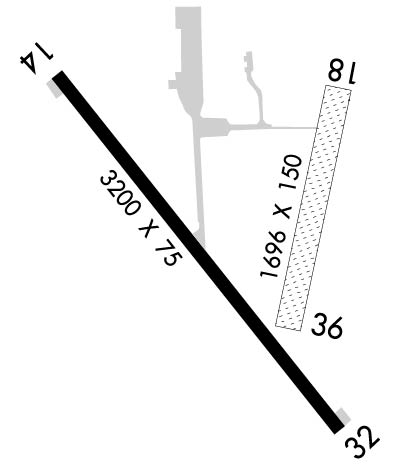
Runway Identifications
Runway Identification: 14/32Length: 4100 ft
Width: 75 ft
Surface: CONCRETE-GOOD CONDITION
Edge lights: Medium IntensityTreatment: NONE
Weight: PCN 6 /R/C/X/T
| | Runway: 14 | | Runway: 32 |
| Mag heading: | 140° | Mag heading: | 320° |
| Rwy Slope: | .09% Up | Rwy Slope: | -.09% Down |
| Approach: | | Approach: | |
| Pattern: | Left Traffic | Pattern: | Left Traffic |
| Markings: | NONPRECISION INSTRUMENT | Markings: | NONPRECISION INSTRUMENT |
| Marking Condition: | GOOD | Marking Condition: | GOOD |
| Arresting Dev: | | Arresting Dev: | |
| Lat & Long: | N4200.8 W09420.8 | Lat. & Long.: | N4200.3 W09420.3 |
| Elev: | 1043.5 ft. MSL | Elev: | 1047.3 ft. MSL |
| TCH: | 33 ft. AGL | TCH: | 36 ft. AGL |
| Visual Glide Path: | 3.00 degrees | Visual Glide Path: | 3.00 degrees |
| Displaced Threshold: | 100 feet | Displaced Threshold: | No |
| Touchdown Zone: | YES | Touchdown Zone: | YES |
| Touchdown Elev.: | 1043.6 feet | Touchdown Elev.: | 1047.3 feet |
| Visual Glide Slope: | 2-Light PAPI on LEFT side of Runway | Visual Glide Slope: | 2-Light PAPI on LEFT side of Runway |
| RVR Equipment: | | RVR Equipment: | |
| RVV Equipment: | NO | RVV Equipment: | NO |
| Approach Lights: | | Approach Lights: | |
| REIL: | YES | REIL: | YES |
| Centerline Lights: | NO | Centerline Lights: | NO |
| Touchdown lights: | NO | Touchdown lights: | NO |
| Runway Category: | Runway with a Non-precision Approach | Runway Category: | Runway with a Non-precision Approach |
| Declared Distances: | | Declared Distances: | |
| Obstructions: | ROAD | Obstructions: | |
| Marked: | NOT Marked/Lighted | Marked: | |
| Clearance slope: | 22:1 | Clearance slope: | 20:1 |
| Obstruction height: | 20 feet AGL | Obstruction height: | |
| Dist. from runway: | 640 feet | Dist. from runway: | |
| Centerline offset: | | Centerline offset: | |
| Comments: | | Comments: | |
Runway Identification: 18/36Length: 1696 ft
Width: 150 ft
Surface: GRASS-FAIR CONDITION
Edge lights: Treatment: NONE
| | Runway: 18 | | Runway: 36 |
| Mag heading: | 189° | Mag heading: | 9° |
| Rwy Slope: | .27% Up | Rwy Slope: | -.27% Down |
| Approach: | | Approach: | |
| Pattern: | Left Traffic | Pattern: | Left Traffic |
| Markings: | NONSTANDARD | Markings: | NONSTANDARD |
| Marking Condition: | GOOD; 18/36 MKD WITH YELLOW CONES. | Marking Condition: | GOOD; RUNWAY 18/36 MARKED WITH YELLOW CONES |
| Arresting Dev: | | Arresting Dev: | |
| Lat & Long: | N4200.8 W09420.4 | Lat. & Long.: | N4200.5 W09420.5 |
| Elev: | 1033.4 ft. MSL | Elev: | 1038.0 ft. MSL |
| TCH: | | TCH: | |
| Visual Glide Path: | | Visual Glide Path: | |
| Displaced Threshold: | No | Displaced Threshold: | No |
| Touchdown Zone: | YES | Touchdown Zone: | YES |
| Touchdown Elev.: | 1038.1 feet | Touchdown Elev.: | 1038.1 feet |
| Visual Glide Slope: | | Visual Glide Slope: | |
| RVR Equipment: | | RVR Equipment: | |
| RVV Equipment: | NO | RVV Equipment: | NO |
| Approach Lights: | | Approach Lights: | |
| REIL: | NO | REIL: | NO |
| Centerline Lights: | NO | Centerline Lights: | NO |
| Touchdown lights: | NO | Touchdown lights: | NO |
| Runway Category: | Runway with a Visual Approach | Runway Category: | Runway with a Visual Approach |
| Declared Distances: | | Declared Distances: | |
| Obstructions: | ROAD | Obstructions: | PLINE |
| Marked: | NOT Marked/Lighted | Marked: | NOT Marked/Lighted |
| Clearance slope: | 31:1 | Clearance slope: | 40:1 |
| Obstruction height: | 19 feet AGL | Obstruction height: | 42 feet AGL |
| Dist. from runway: | 590 feet | Dist. from runway: | 1700 feet |
| Centerline offset: | | Centerline offset: | |
| Comments: | | Comments: | |

