Current Weather/Notams (Metars, TAFs, Notams, NWS Forecast, PIREPS, and nearby weather)
Customs Information Send updates to Support@FltPlan.com
Customs Not Available
Database effective 05/16/2024
Airport Diagram might not be current.
|
| Facility Name: | MONROE MUNI |
| City Name: | MONROE |
| County: | GREEN |
| State abbrev: | WI |
| State Name: | WISCONSIN |
| | |
| Ownership: | PUBLICLY OWNED |
| Use: | OPEN TO THE PUBLIC |
| Owner's Name: | CITY OF MONROE |
| Address: | 1110 18TH AVENUE |
| | MONROE, WI 53566 |
| Owner's Phone: | 608-329-4101 |
| | |
| Manager's Name: | ROB DRIVER |
| Address: | W4711 HWY 59 |
| | MONROE, WI 53566 |
| Phone: | (608) 329-7777 |
| | |
| FAA Region: | GREAT LAKES |
| FAA Field Office: | CHI |
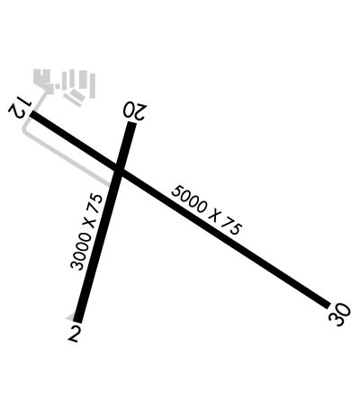
Runway Identifications
Runway Identification: 02/20Length: 3000 ft
Width: 75 ft
Surface: ASPHALT-FAIR CONDITION
Edge lights: Medium IntensityTreatment: NONE
| | Runway: 02 | | Runway: 20 |
| Mag heading: | 16° | Mag heading: | 196° |
| Rwy Slope: | .96% Up | Rwy Slope: | -.96% Down |
| Approach: | | Approach: | |
| Pattern: | Left Traffic | Pattern: | Left Traffic |
| Markings: | BASIC | Markings: | BASIC |
| Marking Condition: | FAIR | Marking Condition: | FAIR |
| Arresting Dev: | | Arresting Dev: | |
| Lat & Long: | N4236.6 W08935.7 | Lat. & Long.: | N4237.1 W08935.5 |
| Elev: | 1056.0 ft. MSL | Elev: | 1084.8 ft. MSL |
| TCH: | 14 ft. AGL | TCH: | |
| Visual Glide Path: | 3.00 degrees | Visual Glide Path: | |
| Displaced Threshold: | No | Displaced Threshold: | No |
| Touchdown Zone: | YES | Touchdown Zone: | YES |
| Touchdown Elev.: | 1085.0 feet | Touchdown Elev.: | 1085.0 feet |
| Visual Glide Slope: | 2-Light PAPI on LEFT side of Runway | Visual Glide Slope: | |
| RVR Equipment: | | RVR Equipment: | |
| RVV Equipment: | NO | RVV Equipment: | NO |
| Approach Lights: | | Approach Lights: | |
| REIL: | YES | REIL: | YES |
| Centerline Lights: | NO | Centerline Lights: | NO |
| Touchdown lights: | NO | Touchdown lights: | NO |
| Runway Category: | Runway with a Visual Approach | Runway Category: | Runway with a Visual Approach |
| Declared Distances: | | Declared Distances: | |
| Obstructions: | TREE | Obstructions: | TREES |
| Marked: | NOT Marked/Lighted | Marked: | NOT Marked/Lighted |
| Clearance slope: | 20:1 | Clearance slope: | 20:1 |
| Obstruction height: | 15 feet AGL | Obstruction height: | 43 feet AGL |
| Dist. from runway: | 340 feet | Dist. from runway: | 890 feet |
| Centerline offset: | 90 left of centerline | Centerline offset: | 150 feet left of centerline |
| Comments: | | Comments: | |
Runway Identification: 12/30Length: 5000 ft
Width: 75 ft
Surface: ASPHALT
Edge lights: Medium IntensityTreatment: NONE
| | Runway: 12 | | Runway: 30 |
| Mag heading: | 122° | Mag heading: | 302° |
| Rwy Slope: | -.48% Down | Rwy Slope: | .48% Up |
| Approach: | | Approach: | |
| Pattern: | Left Traffic | Pattern: | Left Traffic |
| Markings: | NONPRECISION INSTRUMENT | Markings: | NONPRECISION INSTRUMENT |
| Marking Condition: | GOOD | Marking Condition: | GOOD |
| Arresting Dev: | | Arresting Dev: | |
| Lat & Long: | N4237.1 W08935.8 | Lat. & Long.: | N4236.7 W08934.9 |
| Elev: | 1085.5 ft. MSL | Elev: | 1061.5 ft. MSL |
| TCH: | 40 ft. AGL | TCH: | 42 ft. AGL |
| Visual Glide Path: | 3.15 degrees | Visual Glide Path: | 3.00 degrees |
| Displaced Threshold: | No | Displaced Threshold: | No |
| Touchdown Zone: | YES | Touchdown Zone: | YES |
| Touchdown Elev.: | 1085.5 feet | Touchdown Elev.: | 1069.7 feet |
| Visual Glide Slope: | 2-Light PAPI on LEFT side of Runway | Visual Glide Slope: | 2-Light PAPI on LEFT side of Runway; PAPI UNUSBL BYD 6 DEGS RIGHT OF CNTRLN. |
| RVR Equipment: | | RVR Equipment: | |
| RVV Equipment: | NO | RVV Equipment: | NO |
| Approach Lights: | | Approach Lights: | |
| REIL: | YES | REIL: | YES |
| Centerline Lights: | NO | Centerline Lights: | NO |
| Touchdown lights: | NO | Touchdown lights: | NO |
| Runway Category: | Runway with a Non-precision Approach | Runway Category: | Runway with a Non-precision Approach |
| Declared Distances: | | Declared Distances: | |

