Current Weather/Notams (Metars, TAFs, Notams, NWS Forecast, PIREPS, and nearby weather)
Customs Information Send updates to Support@FltPlan.com
Phone 802-873-3219
Fax N/A
Comments On-call basis *3 hrs advance notice required *Maximum passengers per flight: 8 *After 1700 or weekends call 800-973-2867
Database effective 04/18/2024
Airport Diagram might not be current.
|
| Facility Name: | NORTHEAST KINGDOM INTL |
| City Name: | NEWPORT |
| County: | ORLEANS |
| State abbrev: | VT |
| State Name: | VERMONT |
| | |
| Ownership: | PUBLICLY OWNED |
| Use: | OPEN TO THE PUBLIC |
| Owner's Name: | STATE OF VERMONT |
| Address: | 219 N MAIN ST |
| | BARRE, VT 05641 |
| Owner's Phone: | 802-279-2647 |
| | |
| Manager's Name: | ROLLIN TEBBETTS |
| Address: | 219 N MAIN ST |
| | BARRE, VT 05641 |
| Phone: | 802-585-5586 |
| | |
| FAA Region: | NEW ENGLAND |
| FAA Field Office: | NONE |
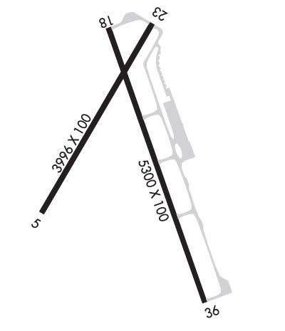
Runway Identifications
Runway Identification: 05/23Length: 3996 ft
Width: 100 ft
Surface: ASPHALT-FAIR CONDITION
Edge lights: Treatment: NONE
| | Runway: 05 | | Runway: 23 |
| Mag heading: | 47° | Mag heading: | 227° |
| Rwy Slope: | .08% Up | Rwy Slope: | -.08% Down |
| Approach: | | Approach: | |
| Pattern: | Left Traffic | Pattern: | Left Traffic |
| Markings: | BASIC | Markings: | BASIC |
| Marking Condition: | FAIR | Marking Condition: | FAIR |
| Arresting Dev: | | Arresting Dev: | |
| Lat & Long: | N4453.1 W07214.1 | Lat. & Long.: | N4453.7 W07213.6 |
| Elev: | 923.1 ft. MSL | Elev: | 926.1 ft. MSL |
| TCH: | | TCH: | |
| Visual Glide Path: | | Visual Glide Path: | |
| Displaced Threshold: | No | Displaced Threshold: | No |
| Touchdown Zone: | YES | Touchdown Zone: | YES |
| Touchdown Elev.: | 928.5 feet | Touchdown Elev.: | 928.6 feet |
| Visual Glide Slope: | | Visual Glide Slope: | |
| RVR Equipment: | | RVR Equipment: | |
| RVV Equipment: | NO | RVV Equipment: | NO |
| Approach Lights: | | Approach Lights: | |
| REIL: | NO | REIL: | NO |
| Centerline Lights: | NO | Centerline Lights: | NO |
| Touchdown lights: | NO | Touchdown lights: | NO |
| Runway Category: | Runway with a Visual Approach | Runway Category: | Runway with a Visual Approach |
| Declared Distances: | | Declared Distances: | |
| Obstructions: | TREES | Obstructions: | POLE |
| Marked: | NOT Marked/Lighted | Marked: | LIGHTED |
| Clearance slope: | 8:1 | Clearance slope: | 20:1 |
| Obstruction height: | 43 feet AGL | Obstruction height: | 32 feet AGL |
| Dist. from runway: | 578 feet | Dist. from runway: | 865 feet |
| Centerline offset: | 80 left of centerline | Centerline offset: | 93 feet left of centerline |
| Comments: | | Comments: | |
Runway Identification: 18/36Length: 5301 ft
Width: 100 ft
Surface: ASPHALT
Edge lights: Medium IntensityTreatment: NONE
Weight: PCN 33 /F/D/X/T
| | Runway: 18 | | Runway: 36 |
| Mag heading: | 177° | Mag heading: | 357° |
| Rwy Slope: | .07% Up | Rwy Slope: | -.07% Down |
| Approach: | | Approach: | |
| Pattern: | Left Traffic | Pattern: | Left Traffic |
| Markings: | NONPRECISION INSTRUMENT | Markings: | NONPRECISION INSTRUMENT |
| Marking Condition: | GOOD | Marking Condition: | GOOD |
| Arresting Dev: | | Arresting Dev: | |
| Lat & Long: | N4453.6 W07213.8 | Lat. & Long.: | N4452.8 W07213.4 |
| Elev: | 930.2 ft. MSL | Elev: | 933.9 ft. MSL |
| TCH: | 43 ft. AGL | TCH: | 44 ft. AGL |
| Visual Glide Path: | 3.00 degrees | Visual Glide Path: | 3.00 degrees |
| Displaced Threshold: | 299 feet | Displaced Threshold: | No |
| Touchdown Zone: | YES | Touchdown Zone: | YES |
| Touchdown Elev.: | 930.4 feet | Touchdown Elev.: | 933.9 feet |
| Visual Glide Slope: | 4-Light PAPI on LEFT side of Runway | Visual Glide Slope: | 4-Light PAPI on LEFT side of Runway |
| RVR Equipment: | | RVR Equipment: | |
| RVV Equipment: | NO | RVV Equipment: | NO |
| Approach Lights: | | Approach Lights: | |
| REIL: | YES | REIL: | YES |
| Centerline Lights: | NO | Centerline Lights: | NO |
| Touchdown lights: | NO | Touchdown lights: | NO |
| Runway Category: | Runway with a Visual Approach | Runway Category: | Runway with a Non-precision Approach |
| Declared Distances: | | Declared Distances: | |
| Obstructions: | | Obstructions: | POLE |
| Marked: | | Marked: | LIGHTED |
| Clearance slope: | 20:1 | Clearance slope: | 25:1 |
| Obstruction height: | | Obstruction height: | 71 feet AGL |
| Dist. from runway: | | Dist. from runway: | 2002 feet |
| Centerline offset: | | Centerline offset: | 126 feet right of centerline |
| Comments: | | Comments: | |

