Current Weather/Notams (Metars, TAFs, Notams, NWS Forecast, PIREPS, and nearby weather)
Customs Information Send updates to Support@FltPlan.com
Customs Not Available
Database effective 04/18/2024
Airport Diagram might not be current.
|
| Facility Name: | DILLANT/HOPKINS |
| City Name: | KEENE |
| County: | CHESHIRE |
| State abbrev: | NH |
| State Name: | NEW HAMPSHIRE |
| | |
| Ownership: | PUBLICLY OWNED |
| Use: | OPEN TO THE PUBLIC |
| Owner's Name: | CITY OF KEENE |
| Address: | 3 WASHINGTON ST |
| | KEENE, NH 03431 |
| Owner's Phone: | 603-357-9835 |
| | |
| Manager's Name: | DAVID HICKLING |
| Address: | 80 AIRPORT RD |
| | KEENE, NH 03431 |
| Phone: | 603-357-9835 |
| | |
| FAA Region: | NEW ENGLAND |
| FAA Field Office: | NONE |
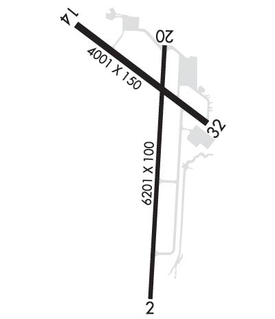
Runway Identifications
Runway Identification: 02/20Length: 6201 ft
Width: 100 ft
Surface: ASPHALT
Edge lights: High IntensityTreatment: NONE
Weight: PCN 40 /F/C/X/T
| | Runway: 02 | | Runway: 20 |
| Mag heading: | 18° | Mag heading: | 198° |
| Rwy Slope: | -.09% Down | Rwy Slope: | .09% Up |
| Approach: | ILS | Approach: | |
| Pattern: | Left Traffic | Pattern: | Left Traffic |
| Markings: | PRECISION INSTRUMENT | Markings: | BASIC |
| Marking Condition: | GOOD | Marking Condition: | GOOD |
| Arresting Dev: | | Arresting Dev: | |
| Lat & Long: | N4253.2 W07216.3 | Lat. & Long.: | N4254.3 W07216.2 |
| Elev: | 488.0 ft. MSL | Elev: | 482.3 ft. MSL |
| TCH: | 39 ft. AGL | TCH: | 50 ft. AGL |
| Visual Glide Path: | 3.00 degrees | Visual Glide Path: | 3.00 degrees |
| Displaced Threshold: | No | Displaced Threshold: | No |
| Touchdown Zone: | YES | Touchdown Zone: | YES |
| Touchdown Elev.: | 488.0 feet | Touchdown Elev.: | 482.3 feet |
| Visual Glide Slope: | 4-Light PAPI on LEFT side of Runway | Visual Glide Slope: | 4-Light PAPI on LEFT side of Runway; PAPI OTS INDEFLY. |
| RVR Equipment: | | RVR Equipment: | |
| RVV Equipment: | NO | RVV Equipment: | NO |
| Approach Lights: | MALSR - 1,400 foot medium intensity approach lighting system with runway alignment indicator lights | Approach Lights: | |
| REIL: | NO | REIL: | NO |
| Centerline Lights: | NO | Centerline Lights: | NO |
| Touchdown lights: | NO | Touchdown lights: | NO |
| Runway Category: | Precision Instrument Runway | Runway Category: | Runway with a Visual Approach |
| Declared Distances: | | Declared Distances: | |
| Obstructions: | TREE | Obstructions: | TREES |
| Marked: | NOT Marked/Lighted | Marked: | NOT Marked/Lighted |
| Clearance slope: | 10:1 | Clearance slope: | 7:1 |
| Obstruction height: | 163 feet AGL | Obstruction height: | 121 feet AGL |
| Dist. from runway: | 1942 feet | Dist. from runway: | 1115 feet |
| Centerline offset: | 273 right of centerline | Centerline offset: | 450 feet left of centerline |
| Comments: | | Comments: | |
Runway Identification: 14/32Length: 4001 ft
Width: 75 ft
Surface: ASPHALT
Edge lights: Medium IntensityTreatment: NONE
Weight: PCN 8 /F/C/X/T
| | Runway: 14 | | Runway: 32 |
| Mag heading: | 142° | Mag heading: | 322° |
| Rwy Slope: | .26% Up | Rwy Slope: | -.26% Down |
| Approach: | | Approach: | |
| Pattern: | Left Traffic | Pattern: | Left Traffic |
| Markings: | BASIC | Markings: | BASIC |
| Marking Condition: | GOOD | Marking Condition: | GOOD |
| Arresting Dev: | | Arresting Dev: | |
| Lat & Long: | N4254.3 W07216.7 | Lat. & Long.: | N4253.9 W07215.9 |
| Elev: | 471.5 ft. MSL | Elev: | 481.9 ft. MSL |
| TCH: | | TCH: | |
| Visual Glide Path: | | Visual Glide Path: | |
| Displaced Threshold: | No | Displaced Threshold: | 1100 feet |
| Touchdown Zone: | YES | Touchdown Zone: | YES |
| Touchdown Elev.: | 475.8 feet | Touchdown Elev.: | 477.6 feet |
| Visual Glide Slope: | | Visual Glide Slope: | |
| RVR Equipment: | | RVR Equipment: | |
| RVV Equipment: | NO | RVV Equipment: | NO |
| Approach Lights: | | Approach Lights: | |
| REIL: | YES | REIL: | YES |
| Centerline Lights: | NO | Centerline Lights: | NO |
| Touchdown lights: | NO | Touchdown lights: | NO |
| Runway Category: | Runway with a Visual Approach | Runway Category: | Runway with a Visual Approach |
| Declared Distances: | | Declared Distances: | |
| Obstructions: | TREES | Obstructions: | TREES |
| Marked: | NOT Marked/Lighted | Marked: | NOT Marked/Lighted |
| Clearance slope: | 17:1 | Clearance slope: | 7:1; APCH RATIO 25:1 TO DTHR. |
| Obstruction height: | 91 feet AGL | Obstruction height: | 44 feet AGL |
| Dist. from runway: | 1803 feet | Dist. from runway: | 530 feet |
| Centerline offset: | 189 left of centerline | Centerline offset: | 46 feet right of centerline |
| Comments: | | Comments: | |

