Click here for more info on on SMS!

KECU

EDWARDS COUNTY
ROCKSPRINGS
TX
Time Zone: Central
Lat: N 2956.8
Long: W 10010.4
Elev: 2372
Var: -07
Longest Runway: 4050
AWOS: 118.17
CTAF: 122.9

FBO & Flight Services info for KECU

FBOs: Update your Fuel Prices

OCONEE COUNTY REGPh: 864-882-2959 Fax: 864-888-4803 Freq: 122.7
Service
Jet
100LL
SAF
MoGas
Fuel Avail: PRIST PREMIXED Vol Discounts
Full6.807.06    Caution: Fuel prices have not been updated in 32 days.
Last Update: 03/17/2024 14:07

Self  6.06    
AWOS
-
Freq: 118.17  
If you are an FBO, call 1-203-262-1700 to update your info or email: FltPlan.Advertising@garmin.com
Advertise your FBO on FltPlan.com

Runway & Approach Info for KECU
Rwy
Length
Land Dist**
Approach*
  Rwy
Length
Land Dist**
Approach*
14
4050x50  3772'          
 
  
32
  4050x50  4050'          
 
 * only ILS, LOC, LDA, and SDF approaches to a specific runway are shown
** For any Declared Landing Distance Available, please see A/FD or Approach plates
Runway Weight Capability (lbs.) Help
Runway IDSingle WheelDouble WheelDouble Tandem WheelDual Double Wheel
14/3213,000N/AN/AN/A
These numbers are Advisory and are not limits.   The Airport Manager should have more accurate Weight Limits
Approach Charts
Approaches    
Current Weather/Notams
Customs Information Send updates to Support@FltPlan.com
Customs Not Available
Database effective 04/18/2024
Airport Diagram of KECU
Airport Diagram might not be current.

Facility Name: EDWARDS COUNTY
City Name: ROCKSPRINGS
County: EDWARDS
State abbrev: TX
State Name: TEXAS
   
Ownership: PUBLICLY OWNED
Use: OPEN TO THE PUBLIC
Owner's Name: COUNTY OF EDWARDS
Address: EDWARDS CTY COURTHOUSE, 100 WEST MAIN
 ROCKSPRINGS, TX 78880
Owner's Phone: 830-683-6122
  
Manager's Name: JASON ARP; ROAD AND BRIDGE SUPT.
Address: , BOX 348
 ROCKSPRINGS, TX 78880
Phone: 830-683-7193
   
FAA Region: SOUTHWEST
FAA Field Office: TEX


Sunrise / Sunset times for EDWARDS COUNTY

DateSunriseSunset
04/17/24 Wednesday7:1120:10
04/18/24 Thursday7:1020:10
04/19/24 Friday7:0920:11
04/20/24 Saturday7:0820:12
04/21/24 Sunday7:0720:12
04/22/24 Monday7:0620:13
04/23/24 Tuesday7:0520:13
04/24/24 Wednesday7:0420:14
04/25/24 Thursday7:0320:15
04/26/24 Friday7:0220:15
04/27/24 Saturday7:0120:16
04/28/24 Sunday7:0020:17
04/29/24 Monday6:5920:17
04/30/24 Tuesday6:5820:18

Airport Facilities

Airport Attendance ScheduleUNATTENDED
Airport Status OPERATIONAL (This Status can change at any time - please check NOTAMS)
Airport Lighting ScheduleSS-SR
Airport Storage AvailableTie Downs
Extra Services AvailableNONE
Wind IndicatorYES - (unlit)
Control TowerNO
CTAF Frequency122.900
Unicom Frequency
Rotating Beacon ColorWG
Segmented CircleYES
Landing FeeNO

Airport Inspection Data

Airport InspectedSTATE - performed by PRIVATE CONTRACT PERSONNEL
Inspection Date03/06/2024

Airport Services

Type of Fuel AvailableNone
Airframe Repair ServiceNONE
Power Plant Repair ServiceNONE

Geographic Data

LatitudeN2956.8
LongitudeW10010.4 (ESTIMATED)
Arpt Elevation2372ft (SURVEYED)
Magnetic Variation07E
4 miles SEof ROCKSPRINGS
Traffic Pattern Altitude
Sectional ChartSAN ANTONIO

Aircraft Data

Operations (Reported)YearlyAvg. Daily
General Aviation Transient 4001
General Aviation Local 2001
Air Taxi 00
Commerical 00
Commuter 00
Military 2201
Aircraft based on Field
General Aviation Singles 2
General Aviation Multi 1
Jet Aircraft 0
General Aviation Helicopters 0
Military Aircraft 0
Gliders 0
Ultralights 0

FAA Services

FSS on field NO
FSS tie-in SAN ANGELO
FSS Phone 1-800-WX-BRIEF
Who issues Notams ECU
Notam D service at airport YES
ARTCC Name HOUSTON

Federal Status

Airport Certification
Aircraft Rescue & Firefighting IndexNone
Airport of EntryNo
Custom Landing RightsNo
Joint Civil/MilitaryNo
Military Landing rightsYES

Remarks

THIS AIRPORT HAS BEEN SURVEYED BY THE NATIONAL GEODETIC SURVEY.
GATE ACES USE FLD ELEV.
FOR CD CTC LAUGHLIN APCH AT 830-298-5192, WHEN APCH CLSD CTC HOUSTON ARTCC AT 281-230-5622.
GRAVEL PIT ADJ TO RWY W SIDE, 12 FT DIRT PILES 156 FT FM RWY CL.
Airport Communications & Frequencies:
CTAF Frequency:
122.900
Remarks
  • APCH/DEP CTL SVC PRVDD BY HOUSTON ARTCC (ZHU) ON FREQS 125.75/346.4 (ROCK SPRINGS RCAG) WHEN DEL RIO APCH CTL (DLF) CLSD.
  • DEL RIO Primary Approach Frequencies:  
    119.6
    259.1
    DEL RIO Primary Departure Frequencies:  
    119.6
    259.1
    296.7
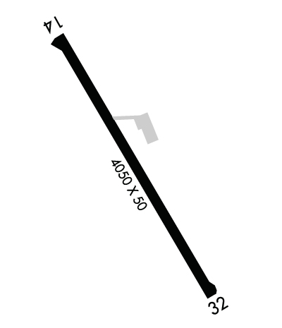
    Runway Identifications
    Runway Identification: 14/32
    Length: 4050 ft
    Width: 50 ft
    Surface: ASPHALT-FAIR CONDITION
    Edge lights: Medium Intensity

    Treatment: NONE

     Runway: 14   Runway: 32
    Mag heading: 138°Mag heading: 318°
    Rwy Slope: .04% UpRwy Slope: -.04% Down
    Approach: Approach:
    Pattern: Left TrafficPattern: Left Traffic
    Markings: NONPRECISION INSTRUMENTMarkings: BASIC
    Marking Condition: POOR; MRKGS FADED.Marking Condition: POOR; MRKGS FADED.
    Arresting Dev: Arresting Dev:
    Lat & Long: N2957.1  W10010.7Lat. & Long.: N2956.5  W10010.2
    Elev: 2367.1 ft. MSLElev: 2368.7 ft. MSL
    TCH: TCH:
    Visual Glide Path: Visual Glide Path:
    Displaced Threshold: 278 feet; NGT OPN DSPLCD THR LGTS ARE 288 FT FM RWY END.Displaced Threshold: No
    Touchdown Zone: YESTouchdown Zone: YES
    Touchdown Elev.: 2372.2 feetTouchdown Elev.: 2372.2 feet
    Visual Glide Slope: Visual Glide Slope:
    RVR Equipment: RVR Equipment:
    RVV Equipment: NORVV Equipment: NO
    Approach Lights: Approach Lights:
    REIL: NOREIL: NO
    Centerline Lights: NOCenterline Lights: NO
    Touchdown lights: NOTouchdown lights: NO
    Runway Category: Runway with a Non-precision ApproachRunway Category: Runway with a Visual Approach
    Declared Distances: Declared Distances:
    Obstructions: TREESObstructions: TREES
    Marked: NOT Marked/LightedMarked: NOT Marked/Lighted
    Clearance slope: 20:1 TO DSPLCD THR OVR 25 FT TREES, 600 FT DSTC, 0 B.Clearance slope: 25:1
    Obstruction height: 25 feet AGLObstruction height: 23 feet AGL
    Dist. from runway: 201 feetDist. from runway: 780 feet
    Centerline offset: Centerline offset: 200 feet right of centerline
    Comments: 8 FT MKD FENCE, 30 FT DSTC.Comments:
    C:2/P: