
| |||||||||||||||||||||||||||||||||||||||||||||||||||||||||||||||||||||
| |||||||||||||||||||||||||||||||||||||||||||||||||||||||||||||||||||||
| |||||||||||||||||||||||||||||||||||||||||||||||||||||||||||||||||||||
| |||||||||||||||||||||||||||||||||||||||||||||||||||||||||||||||||||||
| |||||||||||||||||||||||||||||||||||||||||||||||||||||||||||||||||||||
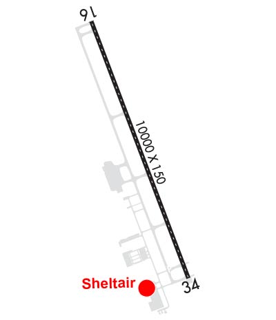
| Rwy | Rwy | |||||||
| 10000x150 | 10000' | 111.15 - 162° | 10000x150 | 10000' | ||||
| Runway ID | Single Wheel | Double Wheel | Double Tandem Wheel | Dual Double Wheel |
| 16/34 | 100,000 | 155,000 | 400,000 | 750,000 |
| These numbers are Advisory and are not limits. The Airport Manager should have more accurate Weight Limits | ||||
 Airport Diagram might not be current. | |
| Facility Name: | NORTHWEST FLORIDA BEACHES INTL |
| City Name: | PANAMA CITY |
| County: | BAY |
| State abbrev: | FL |
| State Name: | FLORIDA |
| Ownership: | PUBLICLY OWNED |
| Use: | OPEN TO THE PUBLIC |
| Owner's Name: | PANAMA CITY-BAY CO ARPT & INDST DIS |
| Address: | 6300 WEST BAY PARKWAY |
| PANAMA CITY BEACH, FL 32409 | |
| Owner's Phone: | 850-763-6751 |
| Manager's Name: | PARKER MCCLELLAN |
| Address: | 6300 WEST BAY PARKWAY |
| PANAMA CITY BEACH, FL 32409 | |
| Phone: | 850-763-6751 |
| FAA Region: | SOUTHERN |
| FAA Field Office: | ORL |
| Date | Sunrise | Sunset |
|---|---|---|
| 04/25/24 Thursday | 6:05 | 19:18 |
| 04/26/24 Friday | 6:04 | 19:18 |
| 04/27/24 Saturday | 6:03 | 19:19 |
| 04/28/24 Sunday | 6:02 | 19:20 |
| 04/29/24 Monday | 6:01 | 19:20 |
| 04/30/24 Tuesday | 6:00 | 19:21 |
| 05/01/24 Wednesday | 5:59 | 19:22 |
| 05/02/24 Thursday | 5:58 | 19:22 |
| 05/03/24 Friday | 5:57 | 19:23 |
| 05/04/24 Saturday | 5:57 | 19:24 |
| 05/05/24 Sunday | 5:56 | 19:24 |
| 05/06/24 Monday | 5:55 | 19:25 |
| 05/07/24 Tuesday | 5:54 | 19:26 |
| 05/08/24 Wednesday | 5:53 | 19:26 |
| Airport Attendance Schedule | CONTINUOUS |
| Airport Status | OPERATIONAL (This Status can change at any time - please check NOTAMS) |
| Airport Lighting Schedule | WHEN ATCT CLSD ACTVT MALSR RWY 16; REIL RWY 34; TDZ RWY 16; CNTLN RWY 16/34; PAPI RWY 16 & 34; HIRL RWY 16/34 - CTAF. |
| Airport Storage Available | Tie Downs, Hanger |
| Extra Services Available | Flight Instruction, Aircraft Rental |
| Wind Indicator | YES - (lighted) |
| Control Tower | YES |
| CTAF Frequency | 118.950 |
| Unicom Frequency | |
| Rotating Beacon Color | WG |
| Segmented Circle | YES |
| Landing Fee |
| Airport Inspected | No Inspection Data Available performed by FAA AIRPORTS FIELD PERSONNEL |
| Inspection Date | 03/15/2024 |
| Type of Fuel Available | Grade 100LL, JET A (freeze point -40C) |
| Airframe Repair Service | None |
| Power Plant Repair Service | None |
| Latitude | N3021.5 |
| Longitude | W08547.7 (ESTIMATED) |
| Arpt Elevation | 68ft (SURVEYED) |
| Magnetic Variation | 03W |
| 16 miles NW | of PANAMA CITY |
| Traffic Pattern Altitude | |
| Sectional Chart | NEW ORLEANS |
| Operations (Reported) | Yearly | Avg. Daily |
|---|---|---|
| General Aviation Transient | 35897 | 98 |
| General Aviation Local | 11773 | 32 |
| Air Taxi | 8288 | 23 |
| Commerical | 13892 | 38 |
| Commuter | 0 | 0 |
| Military | 2816 | 8 |
| Aircraft based on Field | |
|---|---|
| General Aviation Singles | 76 |
| General Aviation Multi | 8 |
| Jet Aircraft | 26 |
| General Aviation Helicopters | 0 |
| Military Aircraft | 0 |
| Gliders | 1 |
| Ultralights | 0 |
| FSS on field | NO |
| FSS tie-in | GAINESVILLE |
| FSS Phone | 1-800-WX-BRIEF |
| Who issues Notams | ECP |
| Notam D service at airport | YES |
| ARTCC Name | JACKSONVILLE |
| Airport Certification | AIRPORT RECEIVING SCHEDULED AIR CARRIER SERVICE FROM CARRIERS CERTIFICATED BY THE CIVIL AERONAUTICS BOARD |
| Aircraft Rescue & Firefighting Index | AIRPORT HAS A CERTIFICATE UNDER CFR PART 139 |
| Airport of Entry | No |
| Custom Landing Rights | No |
| Joint Civil/Military | No |
| Military Landing rights | No |
| NATIONAL PLAN OF INTEGRATED AIRPORT SYSTEMS (NPIAS) |
| MIL VIP ARR/DEP SHALL BE AT ARPT TERM WITH PRIOR APVL FM ARPT AUTH - 850-763-6751 EXT 306. |
| TWY J BTN TWY D & TAXILANE F CLSD TO ACFT WITH WINGSPAN GTR THAN 80 FT EXC 1 HR PPR - 850-769-6033. TWY K, M, E2, E3 BTN TWY D & TAXILANE F RSTRD TO ACFT WITH WINGSPAN GTR THAN 80 FT. |
| BIRDS ON & INVOF ARPT. |
Airport Communications & Frequencies:
| |||||||||||||||||||
| Runway: 16 | Runway: 34 | ||
| Mag heading: | 162° | Mag heading: | 342° |
| Rwy Slope: | -.15% Down | Rwy Slope: | .15% Up |
| Approach: | ILS/DME | Approach: | |
| Pattern: | Left Traffic | Pattern: | Left Traffic |
| Markings: | PRECISION INSTRUMENT | Markings: | PRECISION INSTRUMENT |
| Marking Condition: | GOOD | Marking Condition: | GOOD |
| Arresting Dev: | Arresting Dev: | ||
| Lat & Long: | N3022.3 W08548.1 | Lat. & Long.: | N3020.7 W08547.4 |
| Elev: | 68.8 ft. MSL | Elev: | 53.9 ft. MSL |
| TCH: | 72 ft. AGL | TCH: | 86 ft. AGL |
| Visual Glide Path: | 3.00 degrees | Visual Glide Path: | 3.00 degrees |
| Displaced Threshold: | No | Displaced Threshold: | No |
| Touchdown Zone: | YES | Touchdown Zone: | YES |
| Touchdown Elev.: | 68.8 feet | Touchdown Elev.: | 61.9 feet |
| Visual Glide Slope: | 4-Light PAPI on LEFT side of Runway | Visual Glide Slope: | 4-Light PAPI on LEFT side of Runway |
| RVR Equipment: | TOUCHDOWN-ROLLOUT | RVR Equipment: | TOUCHDOWN-ROLLOUT |
| RVV Equipment: | NO | RVV Equipment: | NO |
| Approach Lights: | MALSR - 1,400 foot medium intensity approach lighting system with runway alignment indicator lights | Approach Lights: | |
| REIL: | NO | REIL: | YES |
| Centerline Lights: | YES | Centerline Lights: | YES |
| Touchdown lights: | YES | Touchdown lights: | NO |
| Runway Category: | Precision Instrument Runway | Runway Category: | D |
| Declared Distances: | Declared Distances: | ||
| Obstructions: | TREES | Obstructions: | TREES |
| Marked: | NOT Marked/Lighted | Marked: | NOT Marked/Lighted |
| Clearance slope: | 50:1 | Clearance slope: | 40:1 |
| Obstruction height: | 39 feet AGL | Obstruction height: | 61 feet AGL |
| Dist. from runway: | 2180 feet | Dist. from runway: | 2660 feet |
| Centerline offset: | 310 right of centerline | Centerline offset: | 595 feet left of centerline |
| Comments: | Comments: |