Current Weather/Notams (Metars, TAFs, Notams, NWS Forecast, PIREPS, and nearby weather)
Customs Information Send updates to Support@FltPlan.com
Customs Not Available
Database effective 05/16/2024
Airport Diagram might not be current. Facility Name: WEBSTER CITY MUNI City Name: WEBSTER CITY County: HAMILTON State abbrev: IA State Name: IOWA Ownership: PUBLICLY OWNED Use: OPEN TO THE PUBLIC Owner's Name: CITY OF WEBSTER CITY; CHAIRMAN ARPT CMSN SCOTT BARGFREDE Address: 400 2ND ST. WEBSTER CITY, IA 50595-0217 Owner's Phone: 515-832-5701 Manager's Name: MIKE LUEDTKE Address: 1524 - 240TH ST; EMAIL ADDRESS: INFO@STORMFLYINGSERVICE.COM WEBSTER CITY, IA 50595 Phone: 515-832-3723 FAA Region: CENTRAL FAA Field Office: NONE
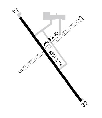
Runway Identifications Help
Runway Identification: 05/23 Length: 2663 ftWidth: 90 ftSurface: GRASS-FAIR CONDITIONEdge lights: Treatment: NONE Runway: 05 Runway: 23 Mag heading: 46° Mag heading: 226° Rwy Slope: -.42% Down Rwy Slope: .42% Up Approach: Approach: Pattern: Left Traffic Pattern: Left Traffic Markings: Markings: Marking Condition: 05/23 THRS & EDGES MKD WITH CONES. Marking Condition: Arresting Dev: Arresting Dev: Lat & Long: N4226.1 W09352.4 Lat. & Long.: N4226.4 W09351.9 Elev: 1118.9 ft. MSL Elev: 1107.6 ft. MSL TCH: TCH: Visual Glide Path: Visual Glide Path: Displaced Threshold: No Displaced Threshold: No Touchdown Zone: YES Touchdown Zone: YES Touchdown Elev.: 1118.9 feet Touchdown Elev.: 1118.9 feet Visual Glide Slope: Visual Glide Slope: RVR Equipment: RVR Equipment: RVV Equipment: NO RVV Equipment: NO Approach Lights: Approach Lights: REIL: NO REIL: NO Centerline Lights: NO Centerline Lights: NO Touchdown lights: NO Touchdown lights: NO Runway Category: Runway with a Visual Approach Runway Category: Runway with a Visual Approach Declared Distances: Declared Distances: Obstructions: CROPS Obstructions: Marked: NOT Marked/Lighted Marked: Clearance slope: 35:1 Clearance slope: 50:1 Obstruction height: 6 feet AGL Obstruction height: Dist. from runway: 210 feet Dist. from runway: Centerline offset: 45 left of centerline Centerline offset: Comments: Comments:
Runway Identification: 14/32 Length: 3851 ftWidth: 75 ftSurface: CONCRETE-GOOD CONDITIONEdge lights: Medium Intensity Treatment: NONEWeight: PCN 5 /R/C/W/U Runway: 14 Runway: 32 Mag heading: 141° Mag heading: 321° Rwy Slope: .41% Up Rwy Slope: -.41% Down Approach: Approach: Pattern: Left Traffic Pattern: Left Traffic Markings: NONPRECISION INSTRUMENT Markings: NONPRECISION INSTRUMENT Marking Condition: FAIR Marking Condition: FAIR Arresting Dev: Arresting Dev: Lat & Long: N4226.4 W09352.4 Lat. & Long.: N4225.9 W09351.9 Elev: 1105.7 ft. MSL Elev: 1121.4 ft. MSL TCH: 25 ft. AGL TCH: 30 ft. AGL Visual Glide Path: 3.25 degrees Visual Glide Path: 3.00 degrees Displaced Threshold: No Displaced Threshold: No Touchdown Zone: YES Touchdown Zone: YES Touchdown Elev.: 1117.3 feet Touchdown Elev.: 1121.5 feet Visual Glide Slope: 2-Light PAPI on LEFT side of Runway Visual Glide Slope: 2-Light PAPI on LEFT side of Runway RVR Equipment: RVR Equipment: RVV Equipment: NO RVV Equipment: NO Approach Lights: Approach Lights: REIL: YES REIL: YES Centerline Lights: NO Centerline Lights: NO Touchdown lights: NO Touchdown lights: NO Runway Category: Runway with a Non-precision Approach Runway Category: Runway with a Non-precision Approach Declared Distances: Declared Distances: Obstructions: ROAD Obstructions: FENCE Marked: NOT Marked/Lighted Marked: NOT Marked/Lighted Clearance slope: 15:1 Clearance slope: 23:1 Obstruction height: 19 feet AGL Obstruction height: 4 feet AGL Dist. from runway: 503 feet Dist. from runway: 293 feet Centerline offset: 290 left of centerline Centerline offset: Comments: Comments: