| ||||||||||||||||||||||||||||||||||||||||||||
| ||||||||||||||||||||||||||||||||||||||||||||
| ||||||||||||||||||||||||||||||||||||||||||||
| FBOs at nearby airports who want your business: | |||||||||||||||||
| |||||||||||||||||
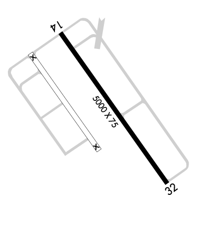
| Rwy | Rwy | |||||||
| 5000x75 | 5000' | 5000x75 | 5000' | |||||
| Runway ID | Single Wheel | Double Wheel | Double Tandem Wheel | Dual Double Wheel |
| 14/32 | 30,000 | N/A | N/A | N/A |
| These numbers are Advisory and are not limits. The Airport Manager should have more accurate Weight Limits | ||||
 Airport Diagram might not be current. | |
| Facility Name: | SOUTH TEXAS INTL AT EDINBURG |
| City Name: | EDINBURG |
| County: | HIDALGO |
| State abbrev: | TX |
| State Name: | TEXAS |
| Ownership: | PUBLICLY OWNED |
| Use: | OPEN TO THE PUBLIC |
| Owner's Name: | CITY OF EDINBURG |
| Address: | PO BOX 1079 |
| EDINBURG, TX 78540 | |
| Owner's Phone: | 956-388-8204 |
| Manager's Name: | EDDIE VELARDE |
| Address: | 1300 E. FM 490 |
| EDINBURG, TX 78542 | |
| Phone: | 956-292-2047; DIRECTOR OF AVIATION JVELARDE@CITYOFEDINBURG.COM |
| FAA Region: | SOUTHWEST |
| FAA Field Office: | TEX |

| Date | Sunrise | Sunset |
|---|---|---|
| 04/22/24 Monday | 7:02 | 20:00 |
| 04/23/24 Tuesday | 7:01 | 20:01 |
| 04/24/24 Wednesday | 7:00 | 20:01 |
| 04/25/24 Thursday | 6:59 | 20:02 |
| 04/26/24 Friday | 6:58 | 20:02 |
| 04/27/24 Saturday | 6:57 | 20:03 |
| 04/28/24 Sunday | 6:57 | 20:04 |
| 04/29/24 Monday | 6:56 | 20:04 |
| 04/30/24 Tuesday | 6:55 | 20:05 |
| 05/01/24 Wednesday | 6:54 | 20:05 |
| 05/02/24 Thursday | 6:53 | 20:06 |
| 05/03/24 Friday | 6:53 | 20:06 |
| 05/04/24 Saturday | 6:52 | 20:07 |
| 05/05/24 Sunday | 6:51 | 20:07 |
| Airport Attendance Schedule | 7 Days A Week 0800-1700 |
| Airport Status | OPERATIONAL (This Status can change at any time - please check NOTAMS) |
| Airport Lighting Schedule | MIRL RWY 14/32 PRESET LOW INTST; TO INCR INTST AND ACTVT REIL RWY 14 - CTAF. PAPI RWYS 14 & 32 OPR CONSLY. |
| Airport Storage Available | Tie Downs |
| Extra Services Available | Flight Instruction |
| Wind Indicator | YES - (lighted) |
| Control Tower | NO |
| CTAF Frequency | 122.800 |
| Unicom Frequency | 122.800 |
| Rotating Beacon Color | WG |
| Segmented Circle | YES |
| Landing Fee | NO |
| Airport Inspected | STATE - performed by PRIVATE CONTRACT PERSONNEL |
| Inspection Date | 04/20/2023 |
| Type of Fuel Available | Grade 100LL, JET A (freeze point -40C); -1024 HRS SELF SERVICE 100LL & JET A. JET A ALSO FULL SERVE. |
| Airframe Repair Service | None |
| Power Plant Repair Service | None |
| Latitude | N2626.5 |
| Longitude | W09807.3 (ESTIMATED) |
| Arpt Elevation | 75ft (ESTIMATED) |
| Magnetic Variation | 06E |
| 9 miles N | of EDINBURG |
| Traffic Pattern Altitude | |
| Sectional Chart | BROWNSVILLE |
| Operations (Reported) | Yearly | Avg. Daily |
|---|---|---|
| General Aviation Transient | 750 | 2 |
| General Aviation Local | 4250 | 12 |
| Air Taxi | 0 | 0 |
| Commerical | 0 | 0 |
| Commuter | 0 | 0 |
| Military | 340 | 1 |
| Aircraft based on Field | |
|---|---|
| General Aviation Singles | 20 |
| General Aviation Multi | 1 |
| Jet Aircraft | 0 |
| General Aviation Helicopters | 1 |
| Military Aircraft | 0 |
| Gliders | 0 |
| Ultralights | 0 |
| FSS on field | NO |
| FSS tie-in | SAN ANGELO |
| FSS Phone | 1-800-WX-BRIEF |
| Who issues Notams | EBG |
| Notam D service at airport | YES |
| ARTCC Name | HOUSTON |
| Airport Certification | |
| Aircraft Rescue & Firefighting Index | None |
| Airport of Entry | No |
| Custom Landing Rights | No; US CUSTOMS USER FEE ARPT. |
| Joint Civil/Military | No |
| Military Landing rights | YES |
| NATIONAL PLAN OF INTEGRATED AIRPORT SYSTEMS (NPIAS) |
| GRANT AGREEMENTS UNDER FAAP/ADAP/AIP |
| SURPLUS PROPERTY AGREEMENT UNDER PUBLIC LAW 289 |
| SURPLUS PROPERTY AGREEMENT UNDER REGULATION 16-WAA |
| ASSURANCES PURSUANT TO TITLE VI, CIVIL RIGHTS ACT OF 1964 |
| THIS AIRPORT HAS BEEN SURVEYED BY THE NATIONAL GEODETIC SURVEY. |
| 100 FT POLE 595 FT NE OF HELIPAD. |
| TWY HAS REFLECTORS ON PAVEMENT. |
| FOR CD CTC CORPUS CHRISTI APCH AT 361-299-4230. |
| CUST AVBL. USER FEE ARPT. M-F 0800-1600. |
| WILDLIFE ACTVTY DLY SS-SR. |
Airport Communications & Frequencies:
| ||||||||||||||
| Runway: 14 | Runway: 32 | ||
| Mag heading: | 138° | Mag heading: | 318° |
| Rwy Slope: | -.05% Down | Rwy Slope: | .05% Up |
| Approach: | Approach: | ||
| Pattern: | Left Traffic | Pattern: | Left Traffic |
| Markings: | NONPRECISION INSTRUMENT | Markings: | NONPRECISION INSTRUMENT |
| Marking Condition: | GOOD | Marking Condition: | GOOD |
| Arresting Dev: | Arresting Dev: | ||
| Lat & Long: | N2626.8 W09807.6 | Lat. & Long.: | N2626.2 W09807.1 |
| Elev: | 75.2 ft. MSL | Elev: | 72.7 ft. MSL |
| TCH: | 42 ft. AGL | TCH: | 45 ft. AGL |
| Visual Glide Path: | 3.00 degrees | Visual Glide Path: | 3.00 degrees |
| Displaced Threshold: | No | Displaced Threshold: | No |
| Touchdown Zone: | YES | Touchdown Zone: | YES |
| Touchdown Elev.: | 75.2 feet | Touchdown Elev.: | 72.7 feet |
| Visual Glide Slope: | 2-Light PAPI on LEFT side of Runway | Visual Glide Slope: | 2-Light PAPI on LEFT side of Runway |
| RVR Equipment: | RVR Equipment: | ||
| RVV Equipment: | NO | RVV Equipment: | NO |
| Approach Lights: | Approach Lights: | ||
| REIL: | YES | REIL: | NO |
| Centerline Lights: | NO | Centerline Lights: | NO |
| Touchdown lights: | NO | Touchdown lights: | NO |
| Runway Category: | Runway with a Non-precision Approach having visibility minimums greater than 3/4 mile | Runway Category: | D |
| Declared Distances: | Declared Distances: |