Click here for more info on on SMS!

KEBA

ELBERT COUNTY-PATZ FIELD
ELBERTON
GA
Time Zone: Eastern
Lat: N 3405.7
Long: W 08249.0
Elev: 615
Var: +06
Longest Runway: 5004
AWOS: 118.15
CTAF: 122.8

FBO & Flight Services info for KEBA

FBOs: Update your Fuel Prices

HARALSON AVIATIONPh: 706-283-2035 Fax: N/A Freq: 122.8
Service
Jet
100LL
SAF
MoGas
Full  4.99    Last Update: 04/01/2024 16:33

Self        
 Address: 1136 VON TRINA RD   ELBERTON, GA 30635
AWOSPh: 706-283-8133
-
Freq: 118.15  
If you are an FBO, call 1-203-262-1700 to update your info or email: FltPlan.Advertising@garmin.com
Advertise your FBO on FltPlan.com

Runway & Approach Info for KEBA
Rwy
Length
Land Dist**
Approach*
  Rwy
Length
Land Dist**
Approach*
11
5004x75  5004'          
 
  
29
  5004x75  5004'          
 
 * only ILS, LOC, LDA, and SDF approaches to a specific runway are shown
** For any Declared Landing Distance Available, please see A/FD or Approach plates
Runway Weight Capability (lbs.) Help
Runway IDSingle WheelDouble WheelDouble Tandem WheelDual Double Wheel
11/2930,000N/AN/AN/A
These numbers are Advisory and are not limits.   The Airport Manager should have more accurate Weight Limits
Approach Charts
Approaches    
Current Weather/Notams
Customs Information Send updates to Support@FltPlan.com
Customs Not Available
Database effective 05/16/2024
Airport Diagram of KEBA
Airport Diagram might not be current.

Facility Name: ELBERT COUNTY-PATZ FLD
City Name: ELBERTON
County: ELBERT
State abbrev: GA
State Name: GEORGIA
   
Ownership: PUBLICLY OWNED
Use: OPEN TO THE PUBLIC
Owner's Name: ELBERT COUNTY
Address: COUNTY COURTHOUSE, 45 FORREST AVENUE
 ELBERTON, GA 30635
Owner's Phone: 706-283-2000
  
Manager's Name: RANDY HARALSON, FBO
Address: 1136 VON TRINA RD
 ELBERTON, GA 30635
Phone: 706-283-2035
   
FAA Region: SOUTHERN
FAA Field Office: ATL


Sunrise / Sunset times for ELBERT COUNTY-PATZ FLD

DateSunriseSunset
04/24/24 Wednesday6:4920:10
04/25/24 Thursday6:4820:11
04/26/24 Friday6:4620:12
04/27/24 Saturday6:4520:13
04/28/24 Sunday6:4420:13
04/29/24 Monday6:4320:14
04/30/24 Tuesday6:4220:15
05/01/24 Wednesday6:4120:16
05/02/24 Thursday6:4020:17
05/03/24 Friday6:3920:17
05/04/24 Saturday6:3820:18
05/05/24 Sunday6:3720:19
05/06/24 Monday6:3620:20
05/07/24 Tuesday6:3520:20

Airport Facilities

Airport Attendance ScheduleMON-SAT 0800-1800, SUN 1300-1800
Airport Status OPERATIONAL (This Status can change at any time - please check NOTAMS)
Airport Lighting ScheduleACTVT PAPI RWY 11 & 29; MIRL RWY 11/29 - CTAF. MIRL RWY 11/29 UNAVBL DURG DALGT HRS, ON PHOTOCELL.
Airport Storage AvailableTie Downs
Extra Services AvailableFlight Instruction
Wind IndicatorYES - (lighted)
Control TowerNO
CTAF Frequency122.800
Unicom Frequency122.800
Rotating Beacon ColorWG
Segmented CircleYES
Landing FeeNO

Airport Inspection Data

Airport InspectedSTATE - performed by STATE AERONAUTICAL PERSONNEL
Inspection Date05/04/2023

Airport Services

Type of Fuel AvailableGrade 100LL
Airframe Repair ServiceNONE
Power Plant Repair ServiceNONE

Geographic Data

LatitudeN3405.7
LongitudeW08249.0 (ESTIMATED)
Arpt Elevation614ft (SURVEYED)
Magnetic Variation06W
2 miles Eof ELBERTON
Traffic Pattern Altitude
Sectional ChartATLANTA

Aircraft Data

Operations (Reported)YearlyAvg. Daily
General Aviation Transient 700019
General Aviation Local 500014
Air Taxi 00
Commerical 00
Commuter 00
Military 00
Aircraft based on Field
General Aviation Singles 23
General Aviation Multi 1
Jet Aircraft 0
General Aviation Helicopters 0
Military Aircraft 0
Gliders 0
Ultralights 0

FAA Services

FSS on field NO
FSS tie-in MACON
FSS Phone 1-800-WX-BRIEF
Who issues Notams MCN
Notam D service at airport YES
ARTCC Name ATLANTA

Federal Status

Airport Certification
Aircraft Rescue & Firefighting IndexNone
Airport of EntryNo
Custom Landing RightsNo
Joint Civil/MilitaryNo
Military Landing rightsYES

Federal Agreements

NATIONAL PLAN OF INTEGRATED AIRPORT SYSTEMS (NPIAS)
GRANT AGREEMENTS UNDER FAAP/ADAP/AIP
ASSURANCES PURSUANT TO TITLE VI, CIVIL RIGHTS ACT OF 1964

Remarks

DEER ON & INVOF ARPT.
ROAD LCTD 200 FT SOUTH OF RCL.
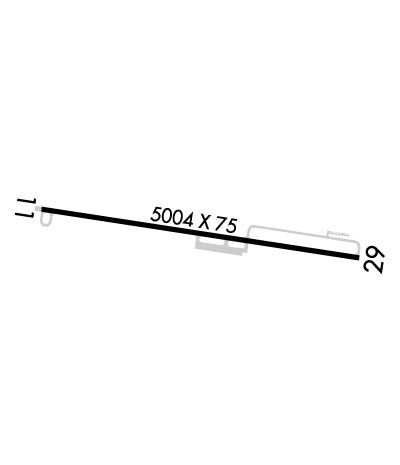
RISING TRRN 10 FT HI LCTD NORTH OF RWY 11/29 STARTING FM RCL.
RWY 29 APCH: TREES 36 FT TALL, LCTD 452 FT FROM RWY END, 280 FT SOUTH OF RCL. TREES 57 FT TALL, LCTD 770 FT FROM RWY END, 295 FT SOUTH OF RCL. TREES 66 FT TALL, LCTD 992 FT FM RWY END, 30 FT SOUTH OF RCL.
FOR CD CTC ATLANTA ARTCC AT 770-210-7692.
Airport Communications & Frequencies:
CTAF Frequency:
122.800
Unicom Frequency:
122.800
Remarks
  • APCH/DEP SVC PRVDD BY ATLANTA ARTCC ON FREQS 127.5/316.05 (ATHENS RCAG).
  • Runway Identifications
    Runway Identification: 11/29
    Length: 5004 ft
    Width: 75 ft
    Surface: ASPHALT-FAIR CONDITION
    Edge lights: Medium Intensity

    Treatment: NONE

     Runway: 11   Runway: 29
    Mag heading: 105°Mag heading: 285°
    Rwy Slope: -.24% DownRwy Slope: .24% Up
    Approach: Approach:
    Pattern: Left TrafficPattern: Left Traffic
    Markings: NONPRECISION INSTRUMENTMarkings: NONPRECISION INSTRUMENT
    Marking Condition: FAIRMarking Condition: FAIR
    Arresting Dev: Arresting Dev:
    Lat & Long: N3405.8  W08249.5Lat. & Long.: N3405.7  W08248.6
    Elev: 614.5 ft. MSLElev: 602.5 ft. MSL
    TCH: 42 ft. AGLTCH: 39 ft. AGL
    Visual Glide Path: 3.75 degreesVisual Glide Path: 3.75 degrees
    Displaced Threshold: NoDisplaced Threshold: No
    Touchdown Zone: YESTouchdown Zone: YES
    Touchdown Elev.: 614.5 feetTouchdown Elev.: 602.5 feet
    Visual Glide Slope: 2-Light PAPI on LEFT side of Runway; RWY 11 PAPI UNUSBL 6 DEGS RIGHT OF RCL.Visual Glide Slope: 2-Light PAPI on LEFT side of Runway; RWY 29 PAPI UNUSBL 8 DEGS LEFT OF RCL.
    RVR Equipment: RVR Equipment:
    RVV Equipment: NORVV Equipment: NO
    Approach Lights: Approach Lights:
    REIL: NOREIL: NO
    Centerline Lights: NOCenterline Lights: NO
    Touchdown lights: NOTouchdown lights: NO
    Runway Category: Runway with a Non-precision Approach having visibility minimums greater than 3/4 mileRunway Category: Runway with a Non-precision Approach having visibility minimums greater than 3/4 mile
    Declared Distances: Declared Distances:
    Obstructions: TREESObstructions: TREES
    Marked: NOT Marked/LightedMarked: NOT Marked/Lighted
    Clearance slope: 15:1Clearance slope: 5:1
    Obstruction height: 44 feet AGLObstruction height: 46 feet AGL
    Dist. from runway: 889 feetDist. from runway: 460 feet
    Centerline offset: 335 right of centerlineCenterline offset: 260 feet left of centerline
    Comments: Comments:
    C:1/P: