Click here for more info on on SMS!

KE77

SAN MANUEL
SAN MANUEL
AZ
Time Zone: Pacific
Lat: N 3238.2
Long: W 11038.8
Elev: 3272
Var: -12
Longest Runway: 4207
AWOS: 134.12
CTAF: 122.9

FBO & Flight Services info for KE77

FBOs: Update your Fuel Prices

SAN MANUELPh: 520-866-6545
-
Freq: 122.9
Service
Jet
100LL
SAF
MoGas
Fuel Avail: 24/7 Self Serve
Full        Last Update: 04/22/2024 13:39

Self        
 Address: SAN-MANUEL AIRPORT HWY 76   SAN-MANUEL, AZ 85631
AWOSPh: 520-385-4238
-
Freq: 134.12  
If you are an FBO, call 1-203-262-1700 to update your info or email: FltPlan.Advertising@garmin.com
Advertise your FBO on FltPlan.com

Runway & Approach Info for KE77
Rwy
Length
Land Dist**
Approach*
  Rwy
Length
Land Dist**
Approach*
11
4207x75  4207'          
 
  
29
  4207x75  4207'          
 
 * only ILS, LOC, LDA, and SDF approaches to a specific runway are shown
** For any Declared Landing Distance Available, please see A/FD or Approach plates
Runway Weight Capability (lbs.) Help
Runway IDSingle WheelDouble WheelDouble Tandem WheelDual Double Wheel
11/2912,000N/AN/AN/A
These numbers are Advisory and are not limits.   The Airport Manager should have more accurate Weight Limits
Approach Charts
FltPlan does not have IFR approach charts available for KE77.
Current Weather/Notams
Customs Information Send updates to Support@FltPlan.com
Customs Not Available
Database effective 05/16/2024
Airport Diagram of KE77
Airport Diagram might not be current.

Facility Name: SAN MANUEL
City Name: SAN MANUEL
County: PINAL
State abbrev: AZ
State Name: ARIZONA
   
Ownership: PUBLICLY OWNED
Use: OPEN TO THE PUBLIC
Owner's Name: PINAL COUNTY
Address: REDINGTON ROAD
 SAN MANUEL, AZ 85631
Owner's Phone: 520-385-3241
  
Manager's Name: JIM PETTY
Address: PO BOX 727
 FLORENCE, AZ 85132
Phone: 520-866-6545; EMERG - SHERIFF 800-420-8689.
   
FAA Region: WESTERN-PACIFIC
FAA Field Office: PHX


Sunrise / Sunset times for SAN MANUEL

DateSunriseSunset
04/24/24 Wednesday5:4219:00
04/25/24 Thursday5:4119:00
04/26/24 Friday5:4019:01
04/27/24 Saturday5:3919:02
04/28/24 Sunday5:3819:03
04/29/24 Monday5:3719:03
04/30/24 Tuesday5:3619:04
05/01/24 Wednesday5:3519:05
05/02/24 Thursday5:3419:05
05/03/24 Friday5:3319:06
05/04/24 Saturday5:3219:07
05/05/24 Sunday5:3119:08
05/06/24 Monday5:3019:08
05/07/24 Tuesday5:2919:09

Airport Facilities

Airport Attendance ScheduleUNATTENDED
Airport Status OPERATIONAL (This Status can change at any time - please check NOTAMS)
Airport Lighting ScheduleACTVT PAPI RWY 11 & 29; MIRL RWY 11/29 - CTAF.
Airport Storage AvailableTie Downs
Extra Services AvailableFlight Instruction
Wind IndicatorYES - (lighted)
Control TowerNO
CTAF Frequency122.900
Unicom Frequency
Rotating Beacon ColorWG
Segmented CircleYES
Landing FeeNO

Airport Inspection Data

Airport InspectedSTATE - performed by PRIVATE CONTRACT PERSONNEL
Inspection Date04/13/2023

Airport Services

Type of Fuel AvailableGrade 100LL; -10AVBL H24 WITH CREDIT CARD; EXC AMERICAN EXPRESS.
Airframe Repair ServiceNone
Power Plant Repair ServiceNone

Geographic Data

LatitudeN3238.2
LongitudeW11038.8 (ESTIMATED)
Arpt Elevation3271ft (SURVEYED)
Magnetic Variation12E
2 miles NWof SAN MANUEL
Traffic Pattern Altitude
Sectional ChartPHOENIX

Aircraft Data

Operations (Reported)YearlyAvg. Daily
General Aviation Transient 20005
General Aviation Local 1200033
Air Taxi 00
Commerical 00
Commuter 00
Military 3001
Aircraft based on Field
General Aviation Singles 14
General Aviation Multi 0
Jet Aircraft 0
General Aviation Helicopters 1
Military Aircraft 0
Gliders 0
Ultralights 0

FAA Services

FSS on field NO
FSS tie-in PRESCOTT
FSS Phone 1-800-WX-BRIEF
Who issues Notams PRC
Notam D service at airport YES
ARTCC Name ALBUQUERQUE

Federal Status

Airport Certification
Aircraft Rescue & Firefighting IndexNone
Airport of EntryNo
Custom Landing RightsNo
Joint Civil/MilitaryNo
Military Landing rightsNo

Federal Agreements

NATIONAL PLAN OF INTEGRATED AIRPORT SYSTEMS (NPIAS)

Remarks

RISING TRRN W; 75 FT HILL 500-1000 FT FM RWY END 350-500 FT R OF CNTRLN.
FOR CD CTC ALBUQUERQUE ARTCC AT 505-856-4861.
RWY 11/2 9 2-4 FT BRUSH IN PRIM SFC 45-75 FT FM CNTRLN.
RWY 11 6 FT GULLY 300 FT FM THR.
RWY 29 6 FT DROP OFF 90 FT R OF CNTRLN 165 - 325 FT FM THR.
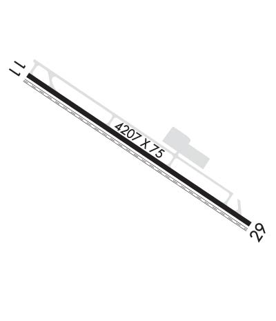
Runway Identifications
Runway Identification: 11/29
Length: 4207 ft
Width: 75 ft
Surface: ASPHALT-GOOD CONDITION
Edge lights: Medium Intensity

Treatment: NONE

 Runway: 11   Runway: 29
Mag heading: N/AMag heading: N/A
Rwy Slope: -.51% DownRwy Slope: .51% Up
Approach: Approach:
Pattern: Left TrafficPattern: Right Traffic
Markings: BASICMarkings: BASIC
Marking Condition: GOODMarking Condition: GOOD
Arresting Dev: Arresting Dev:
Lat & Long: N3238.4  W11039.2Lat. & Long.: N3238.0  W11038.5
Elev: 3271.7 ft. MSLElev: 3250.3 ft. MSL
TCH: 44 ft. AGLTCH: 43 ft. AGL
Visual Glide Path: 3.00 degreesVisual Glide Path: 3.00 degrees
Displaced Threshold: NoDisplaced Threshold: No
Touchdown Zone: YESTouchdown Zone: YES
Touchdown Elev.: 3271.8 feetTouchdown Elev.: 3263.9 feet
Visual Glide Slope: 2-Light PAPI on LEFT side of RunwayVisual Glide Slope: 2-Light PAPI on RIGHT side of Runway
RVR Equipment: RVR Equipment:
RVV Equipment: NORVV Equipment: NO
Approach Lights: Approach Lights:
REIL: NOREIL: NO
Centerline Lights: NOCenterline Lights: NO
Touchdown lights: NOTouchdown lights: NO
Runway Category: Runway with a Visual ApproachRunway Category: Runway with a Visual Approach
Declared Distances: Declared Distances:
Obstructions: Obstructions: BRUSH
Marked: Marked: NOT Marked/Lighted
Clearance slope: 20:1; CTL OBSTN EXCEEDS 45 DEG SLOPE.Clearance slope:
Obstruction height: Obstruction height: 6 feet AGL
Dist. from runway: Dist. from runway: 205 feet
Centerline offset: Centerline offset: 115 feet left of centerline
Comments: Comments: 3-6 FT BRUSH 0-200 FT FM THR 90-125 FT L OF CNTRLN; 3-5 FT BRUSH 50-100 FT FM THR 50-70 FT R OF CNTRLN.
C:/P: