Click here for more info on on SMS!

KE60

ELOY MUNI
ELOY
AZ
Time Zone: Pacific
Lat: N 3248.4
Long: W 11135.2
Elev: 1511
Var: -12
Longest Runway: 3901
CTAF: 122.8

FBO & Flight Services info for KE60

FBOs: Update your Fuel Prices

BEL AMERICAPh: 520-466-4721 Fax: 520-466-4720
-
Service
Jet
100LL
SAF
MoGas
Full        Last Update: 04/19/2024 12:04

Self4.505.50    
 Address: LEAR DR   ELOY, AZ 85131
If you are an FBO, call 1-203-262-1700 to update your info or email: FltPlan.Advertising@garmin.com
Advertise your FBO on FltPlan.com

Runway & Approach Info for KE60
Rwy
Length
Land Dist**
Approach*
  Rwy
Length
Land Dist**
Approach*
02
3901x75  3901'          
 
  
20
  3901x75  3901'          
 
 * only ILS, LOC, LDA, and SDF approaches to a specific runway are shown
** For any Declared Landing Distance Available, please see A/FD or Approach plates
Runway Weight Capability (lbs.) Help
Runway IDSingle WheelDouble WheelDouble Tandem WheelDual Double Wheel
02/20N/AN/AN/AN/A
These numbers are Advisory and are not limits.   The Airport Manager should have more accurate Weight Limits
Approach Charts
FltPlan does not have IFR approach charts available for KE60.
Current Weather/Notams
Customs Information Send updates to Support@FltPlan.com
Customs Not Available
Database effective 05/16/2024
Airport Diagram of KE60
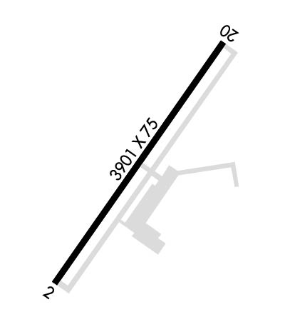
Airport Diagram might not be current.

Facility Name: ELOY MUNI
City Name: ELOY
County: PINAL
State abbrev: AZ
State Name: ARIZONA
   
Ownership: PUBLICLY OWNED
Use: OPEN TO THE PUBLIC
Owner's Name: CITY OF ELOY
Address: 628 N. MAIN STREET
 ELOY, AZ 85231
Owner's Phone: 520-466-9201
  
Manager's Name: KAZI HAQUE; ADDITIONAL CONTACT ARIZONA SKYDIVE 520-466-3753 OR KAZI HAQUE, CITY OF ELOY, AT 520-466-2552.
Address: C/O CITY OF ELOY, 595 NORTH "C" ST.
 ELOY, AZ 85131
Phone: 520-466-9201
   
FAA Region: WESTERN-PACIFIC
FAA Field Office: PHX


Sunrise / Sunset times for ELOY MUNI

DateSunriseSunset
04/25/24 Thursday5:4419:04
04/26/24 Friday5:4319:05
04/27/24 Saturday5:4219:06
04/28/24 Sunday5:4119:07
04/29/24 Monday5:4019:07
04/30/24 Tuesday5:3919:08
05/01/24 Wednesday5:3819:09
05/02/24 Thursday5:3719:10
05/03/24 Friday5:3619:10
05/04/24 Saturday5:3619:11
05/05/24 Sunday5:3519:12
05/06/24 Monday5:3419:12
05/07/24 Tuesday5:3319:13
05/08/24 Wednesday5:3219:14

Airport Facilities

Airport Attendance Schedule7 Days A Week 0700-1600
Airport Status OPERATIONAL (This Status can change at any time - please check NOTAMS)
Airport Lighting ScheduleSS-SR
Airport Storage AvailableTie Downs, Hanger
Extra Services AvailableCrop Dusting, Parachute Jumping
Wind IndicatorYES - (lighted)
Control TowerNO
CTAF Frequency122.800
Unicom Frequency122.800
Rotating Beacon ColorWG
Segmented CircleYES
Landing FeeNO

Airport Inspection Data

Airport InspectedFEDERAL - performed by PRIVATE CONTRACT PERSONNEL
Inspection Date04/17/2023

Airport Services

Type of Fuel AvailableGrade 100LL, JET A (freeze point -40C)
Airframe Repair ServiceMAJOR
Power Plant Repair ServiceMAJOR

Geographic Data

LatitudeN3248.4
LongitudeW11135.2 (ESTIMATED)
Arpt Elevation1511ft (SURVEYED)
Magnetic Variation12E
3 miles NWof ELOY
Traffic Pattern Altitude800
Sectional ChartPHOENIX

Aircraft Data

Operations (Reported)YearlyAvg. Daily
General Aviation Transient 450012
General Aviation Local 2540070
Air Taxi 00
Commerical 00
Commuter 00
Military 1000
Aircraft based on Field
General Aviation Singles 16
General Aviation Multi 14
Jet Aircraft 0
General Aviation Helicopters 0
Military Aircraft 0
Gliders 0
Ultralights 0

FAA Services

FSS on field NO
FSS tie-in PRESCOTT
FSS Phone 1-800-WX-BRIEF
Who issues Notams PRC
Notam D service at airport YES
ARTCC Name ALBUQUERQUE

Federal Status

Airport Certification
Aircraft Rescue & Firefighting IndexNone
Airport of EntryNo
Custom Landing RightsNo
Joint Civil/MilitaryNo
Military Landing rightsYES

Federal Agreements

NATIONAL PLAN OF INTEGRATED AIRPORT SYSTEMS (NPIAS)
GRANT AGREEMENTS UNDER FAAP/ADAP/AIP
ASSURANCES PURSUANT TO TITLE VI, CIVIL RIGHTS ACT OF 1964

Remarks

SEASONAL CROP DUSTING OPERATION.
APCH FM WEST AND DO NOT OVERFLY ARPT; EXTREMELY HEAVY PARACHUTE JUMPING ACTIVITY OVER EAST SIDE OF ARPT SR-SS.
WHEN WINDS 10 KTS OR LESS DEP RY 02 AND LAND RY 20.
SELF-FUELING AVAILABLE 24 HOURS WITH MAJOR CREDIT CARD.
FOR CD CTC ALBUQUERQUE ARTCC AT 505-856-4861.
Runway Identifications
Runway Identification: 02/20
Length: 3901 ft
Width: 75 ft
Surface: ASPHALT-GOOD CONDITION
Edge lights: Medium Intensity

Treatment: NONE

 Runway: 02   Runway: 20
Mag heading: 26°Mag heading: 206°
Rwy Slope: -.16% DownRwy Slope: .16% Up
Approach: Approach:
Pattern: Left TrafficPattern: Right Traffic
Markings: BASICMarkings: BASIC
Marking Condition: GOODMarking Condition: GOOD
Arresting Dev: Arresting Dev:
Lat & Long: N3248.1  W11135.4Lat. & Long.: N3248.7  W11135.0
Elev: 1511.2 ft. MSLElev: 1504.8 ft. MSL
TCH: 43 ft. AGLTCH: 42 ft. AGL
Visual Glide Path: 3.00 degreesVisual Glide Path: 3.00 degrees
Displaced Threshold: NoDisplaced Threshold: No
Touchdown Zone: YESTouchdown Zone: YES
Touchdown Elev.: 1511.2 feetTouchdown Elev.: 1508.9 feet
Visual Glide Slope: 2-Light PAPI on LEFT side of Runway; PAPI RY 02 OPERATES CONTINUOUSLY.Visual Glide Slope: 2-Light PAPI on LEFT side of Runway; PAPI RY 20 OPERATES CONTINUOUSLY.
RVR Equipment: RVR Equipment:
RVV Equipment: NORVV Equipment: NO
Approach Lights: Approach Lights:
REIL: YES; REIL RY 02 OPERATES CONTINUOUSLY.REIL: YES; REIL RY 20 OPERATES CONTINUOUSLY.
Centerline Lights: NOCenterline Lights: NO
Touchdown lights: NOTouchdown lights: NO
Runway Category: Runway with a Visual ApproachRunway Category: Runway with a Visual Approach
Declared Distances: Declared Distances:
Comments: RWY 02 SCATTERED 1-2 FT BRUSH, 0-200 FT FM THLD, ACROSS THLD.Comments: RWY 20, 1-3 FT BRUSH 0-200 FT FM THR, 75-250 FT LEFT OF CNTRLN; 1-4 FT BRUSH, 100-200 FM THR, 75-250 FT RIGHT OF CNTRLN.
C:/P: