Click here for more info on on SMS!

KE51

BAGDAD
BAGDAD
AZ
Time Zone: Pacific
Lat: N 3435.6
Long: W 11310.3
Elev: 4196
Var: -13
Longest Runway: 4552
CTAF: 122.9

FBO & Flight Services info for KE51

FBOs: Update your Fuel Prices

AIRPORTPh: 520-663-2521
-
Freq: 122.9
Service
Jet
100LL
SAF
MoGas
Fuel Avail: NO FUEL AVAILABLE
Full        Last Update: 04/24/2024 06:02:16

Self        
If you are an FBO, call 1-203-262-1700 to update your info or email: FltPlan.Advertising@garmin.com
Advertise your FBO on FltPlan.com

Runway & Approach Info for KE51
Rwy
Length
Land Dist**
Approach*
  Rwy
Length
Land Dist**
Approach*
05
4552x60  4552'          
 
  
23
  4552x60  4552'          
 
 * only ILS, LOC, LDA, and SDF approaches to a specific runway are shown
** For any Declared Landing Distance Available, please see A/FD or Approach plates
Runway Weight Capability (lbs.) Help
Runway IDSingle WheelDouble WheelDouble Tandem WheelDual Double Wheel
05/234,000N/AN/AN/A
These numbers are Advisory and are not limits.   The Airport Manager should have more accurate Weight Limits
Approach Charts
FltPlan does not have IFR approach charts available for KE51.
Current Weather/Notams
Customs Information Send updates to Support@FltPlan.com
Customs Not Available
Database effective 05/16/2024
Airport Diagram of KE51
Airport Diagram might not be current.

Facility Name: BAGDAD
City Name: BAGDAD
County: YAVAPAI
State abbrev: AZ
State Name: ARIZONA
   
Ownership: PUBLICLY OWNED
Use: OPEN TO THE PUBLIC
Owner's Name: YAVAPAI COUNTY
Address: 1100 COMMERCE DR
 PRESCOTT, AZ 86305
Owner's Phone: 928-771-3183
  
Manager's Name: CHRIS STEELE; KATHRYN RODD - 928-777-7521.
Address: 1100 COMMERCE DRIVE
 PRESCOTT, AZ 86305
Phone: 928-771-3183; EMERG - 928-771-3260 SHERIFF OFC.
   
FAA Region: WESTERN-PACIFIC
FAA Field Office: PHX


Sunrise / Sunset times for BAGDAD

DateSunriseSunset
04/24/24 Wednesday5:4919:13
04/25/24 Thursday5:4819:13
04/26/24 Friday5:4719:14
04/27/24 Saturday5:4619:15
04/28/24 Sunday5:4519:16
04/29/24 Monday5:4419:17
04/30/24 Tuesday5:4319:17
05/01/24 Wednesday5:4219:18
05/02/24 Thursday5:4119:19
05/03/24 Friday5:4019:20
05/04/24 Saturday5:3919:21
05/05/24 Sunday5:3819:21
05/06/24 Monday5:3719:22
05/07/24 Tuesday5:3619:23

Airport Facilities

Airport Attendance ScheduleUNATTENDED
Airport Status OPERATIONAL (This Status can change at any time - please check NOTAMS)
Airport Lighting Schedule
Airport Storage AvailableTie Downs
Extra Services AvailableNONE
Wind IndicatorYES - (unlit)
Control TowerNO
CTAF Frequency122.900
Unicom Frequency
Rotating Beacon Color
Segmented CircleNO
Landing FeeNO

Airport Inspection Data

Airport InspectedSTATE - performed by PRIVATE CONTRACT PERSONNEL
Inspection Date05/13/2022

Airport Services

Type of Fuel AvailableNone
Airframe Repair ServiceNone
Power Plant Repair ServiceNone

Geographic Data

LatitudeN3435.6
LongitudeW11310.3 (ESTIMATED)
Arpt Elevation4195ft (ESTIMATED)
Magnetic Variation13E
2 miles NEof BAGDAD
Traffic Pattern Altitude
Sectional ChartPHOENIX

Aircraft Data

Operations (Reported)YearlyAvg. Daily
General Aviation Transient 6002
General Aviation Local 4001
Air Taxi 00
Commerical 00
Commuter 00
Military 00
Aircraft based on Field
General Aviation Singles 3
General Aviation Multi 0
Jet Aircraft 0
General Aviation Helicopters 0
Military Aircraft 0
Gliders 0
Ultralights 0

FAA Services

FSS on field NO
FSS tie-in PRESCOTT
FSS Phone 1-800-WX-BRIEF
Who issues Notams PRC
Notam D service at airport YES
ARTCC Name ALBUQUERQUE

Federal Status

Airport Certification
Aircraft Rescue & Firefighting IndexNone
Airport of EntryNo
Custom Landing RightsNo
Joint Civil/MilitaryNo
Military Landing rightsYES

Federal Agreements

NATIONAL PLAN OF INTEGRATED AIRPORT SYSTEMS (NPIAS)
GRANT AGREEMENTS UNDER FAAP/ADAP/AIP
ASSURANCES PURSUANT TO TITLE VI, CIVIL RIGHTS ACT OF 1964

Remarks

UNUSABLE AIR CURRENT INVOF APRT; SPCLY RWY 23 APCH END.
MTNS E; NE; NW ABV PART 77 CONICAL SFDC.
LCTD ON MESA.
Airport Communications & Frequencies:
CTAF Frequency:
122.900
Remarks
  • COMMUNICATIONS PRVDD BY PRESCOTT RADIO ON FREQ 122.5 (BAGDAD RCO).
  • Runway Identifications
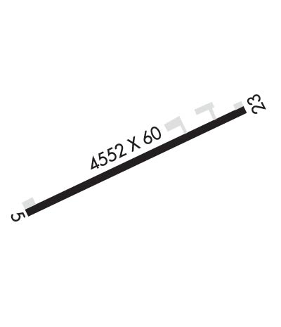
    Runway Identification: 05/23
    Length: 4552 ft
    Width: 60 ft
    Surface: ASPHALT-GOOD CONDITION
    Edge lights:

    Treatment: NONE

     Runway: 05   Runway: 23
    Mag heading: 55°Mag heading: 235°
    Rwy Slope: -.20% DownRwy Slope: .20% Up
    Approach: Approach:
    Pattern: Left TrafficPattern: Left Traffic
    Markings: BASICMarkings: BASIC
    Marking Condition: GOODMarking Condition: GOOD
    Arresting Dev: Arresting Dev:
    Lat & Long: N3435.4  W11310.7Lat. & Long.: N3435.7  W11309.9
    Elev: 4195.7 ft. MSLElev: 4186.7 ft. MSL
    TCH: TCH:
    Visual Glide Path: Visual Glide Path:
    Displaced Threshold: NoDisplaced Threshold: No
    Touchdown Zone: NOTouchdown Zone: NO
    Touchdown Elev.: Touchdown Elev.:
    Visual Glide Slope: Visual Glide Slope:
    RVR Equipment: RVR Equipment:
    RVV Equipment: NORVV Equipment: NO
    Approach Lights: Approach Lights:
    REIL: NOREIL: NO
    Centerline Lights: NOCenterline Lights: NO
    Touchdown lights: NOTouchdown lights: NO
    Runway Category: Runway with a Visual ApproachRunway Category: Runway with a Visual Approach
    Declared Distances: Declared Distances:
    Obstructions: Obstructions: FENCE
    Marked: Marked: NOT Marked/Lighted
    Clearance slope: 50:1Clearance slope: 20:1
    Obstruction height: Obstruction height: 2 feet AGL
    Dist. from runway: Dist. from runway: 240 feet
    Centerline offset: Centerline offset: 125 feet right of centerline
    Comments: Comments: +2-4 FT BRUSH, 90-200 FT FM THR, 60-125 FT R OF CNTRLN. +4-8 FT BRUSH, 0-200 FT FM THR, 60-125 FT L OF CNTRLN.
    C:/P: