Click here for more info on on SMS!

KE45

PINE MOUNTAIN LAKE
GROVELAND
CA
Time Zone: Pacific
Lat: N 3751.7
Long: W 12010.7
Elev: 2933
Var: -15
Longest Runway: 3624
CTAF: 122.9

FBO & Flight Services info for KE45

FBOs: Update your Fuel Prices

AIRPORTPh: 209-303-5385 Fax: 209-962-6472 Freq: 122.9

If you are an FBO, call 1-203-262-1700 to update your info or email: FltPlan.Advertising@garmin.com
Advertise your FBO on FltPlan.com

Runway & Approach Info for KE45
Rwy
Length
Land Dist**
Approach*
  Rwy
Length
Land Dist**
Approach*
09
3624x50  3624'          
 
  
27
  3624x50  3624'          
 
 * only ILS, LOC, LDA, and SDF approaches to a specific runway are shown
** For any Declared Landing Distance Available, please see A/FD or Approach plates
Runway Weight Capability (lbs.) Help
Runway IDSingle WheelDouble WheelDouble Tandem WheelDual Double Wheel
09/2712,000N/AN/AN/A
These numbers are Advisory and are not limits.   The Airport Manager should have more accurate Weight Limits
Approach Charts
Approaches    
Current Weather/Notams
Customs Information Send updates to Support@FltPlan.com
Customs Not Available
Database effective 05/16/2024
Airport Diagram of KE45
Airport Diagram might not be current.

Facility Name: PINE MOUNTAIN LAKE
City Name: GROVELAND
County: TUOLUMNE
State abbrev: CA
State Name: CALIFORNIA
   
Ownership: PUBLICLY OWNED
Use: OPEN TO THE PUBLIC
Owner's Name: TULOUMNE COUNTY
Address: 2 SOUTH GREEN ST.
 SONORA, CA 95370
Owner's Phone: 209-533-5685
  
Manager's Name: KIM MACFARLANE
Address: 10723 AIRPORT RD
 COLUMBIA, CA 95310
Phone: 209-533-5685; OFFICE AT COLUMBIA, CA ARPT.
   
FAA Region: WESTERN-PACIFIC
FAA Field Office: SFO


Sunrise / Sunset times for PINE MOUNTAIN LAKE

DateSunriseSunset
04/25/24 Thursday6:1119:47
04/26/24 Friday6:1019:48
04/27/24 Saturday6:0919:48
04/28/24 Sunday6:0719:49
04/29/24 Monday6:0619:50
04/30/24 Tuesday6:0519:51
05/01/24 Wednesday6:0419:52
05/02/24 Thursday6:0319:53
05/03/24 Friday6:0219:54
05/04/24 Saturday6:0019:55
05/05/24 Sunday5:5919:56
05/06/24 Monday5:5819:57
05/07/24 Tuesday5:5719:58
05/08/24 Wednesday5:5619:58

Airport Facilities

Airport Attendance ScheduleUNATTENDED
Airport Status OPERATIONAL (This Status can change at any time - please check NOTAMS)
Airport Lighting ScheduleACTVT MIRL RY 09/27 - CTAF.
Airport Storage AvailableTie Downs
Extra Services AvailableNONE
Wind IndicatorYES - (lighted)
Control TowerNO
CTAF Frequency122.900
Unicom Frequency
Rotating Beacon ColorWG
Segmented CircleYES
Landing FeeNO

Airport Inspection Data

Airport InspectedSTATE - performed by STATE AERONAUTICAL PERSONNEL
Inspection Date11/02/2023

Airport Services

Type of Fuel AvailableGrade 100LL; -10FUEL 24 HR SELF-SERVICE.
Airframe Repair ServiceNONE
Power Plant Repair ServiceNONE

Geographic Data

LatitudeN3751.7
LongitudeW12010.7 (ESTIMATED)
Arpt Elevation2932ft (SURVEYED)
Magnetic Variation15E
3 miles NEof GROVELAND
Traffic Pattern Altitude
Sectional ChartSAN FRANCISCO

Aircraft Data

Operations (Reported)YearlyAvg. Daily
General Aviation Transient 825023
General Aviation Local 675018
Air Taxi 00
Commerical 00
Commuter 00
Military 00
Aircraft based on Field
General Aviation Singles 11
General Aviation Multi 1
Jet Aircraft 0
General Aviation Helicopters 0
Military Aircraft 0
Gliders 0
Ultralights 0

FAA Services

FSS on field NO
FSS tie-in RANCHO MURIETA
FSS Phone 1-800-WX-BRIEF
Who issues Notams RIU
Notam D service at airport YES
ARTCC Name OAKLAND

Federal Status

Airport Certification
Aircraft Rescue & Firefighting IndexNone
Airport of EntryNo
Custom Landing RightsNo
Joint Civil/MilitaryNo
Military Landing rightsNo

Federal Agreements

NATIONAL PLAN OF INTEGRATED AIRPORT SYSTEMS (NPIAS)
GRANT AGREEMENTS UNDER FAAP/ADAP/AIP
ASSURANCES PURSUANT TO TITLE VI, CIVIL RIGHTS ACT OF 1964

Remarks

THIS AIRPORT HAS BEEN SURVEYED BY THE NATIONAL GEODETIC SURVEY.
TRANSIENT PARKING AVBL.
FEE FOR OVERNIGHT PARKING.
(E81) RWY EXIT LGTS.
DEER ON & INVOF ARPT AT ALL TIMES.
FOR CD CTC OAKLAND ARTCC AT 510-745-3380.
RWY 09/2 7 200 FT GRVL RY SAFETY AREA WEST END; 100 FT GRVL RY SAFETY AREA EAST END.
Airport Communications & Frequencies:
CTAF Frequency:
122.900
Remarks
  • APCH/DEP CTL SVC PRVDD BY OAKLAND ARTCC (ZOA) ON FREQS 121.25/327.0 (ANGELS CAMP RCAG).
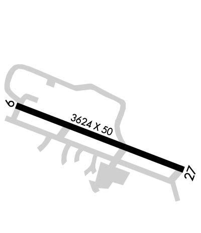
  • Runway Identifications
    Runway Identification: 09/27
    Length: 3624 ft
    Width: 50 ft
    Surface: ASPHALT-GOOD CONDITION
    Edge lights: Medium Intensity

    Treatment: NONE

     Runway: 09   Runway: 27
    Mag heading: 95°Mag heading: 275°
    Rwy Slope: 1.03% UpRwy Slope: -1.03% Down
    Approach: Approach:
    Pattern: Left TrafficPattern: Right Traffic
    Markings: NONPRECISION INSTRUMENTMarkings: NONPRECISION INSTRUMENT
    Marking Condition: GOODMarking Condition: GOOD
    Arresting Dev: Arresting Dev:
    Lat & Long: N3751.8  W12011.1Lat. & Long.: N3751.6  W12010.4
    Elev: 2895.1 ft. MSLElev: 2932.6 ft. MSL
    TCH: 24 ft. AGLTCH: 21 ft. AGL
    Visual Glide Path: 4.50 degreesVisual Glide Path: 4.00 degrees
    Displaced Threshold: NoDisplaced Threshold: No
    Touchdown Zone: YESTouchdown Zone: YES
    Touchdown Elev.: 2921.5 feetTouchdown Elev.: 2932.6 feet
    Visual Glide Slope: 2-Box VASI on LEFT side of RunwayVisual Glide Slope: 2-Light PAPI on LEFT side of Runway; PAPI RY 27 UNUSABLE BYD 7 DEG LEFT AND RIGHT OF CENTERLINE.
    RVR Equipment: RVR Equipment:
    RVV Equipment: NORVV Equipment: NO
    Approach Lights: Approach Lights:
    REIL: NOREIL: NO
    Centerline Lights: NOCenterline Lights: NO
    Touchdown lights: NOTouchdown lights: NO
    Runway Category: Runway with a Non-precision ApproachRunway Category: Runway with a Non-precision Approach
    Declared Distances: Declared Distances:
    Obstructions: TREESObstructions: TREES
    Marked: NOT Marked/LightedMarked: NOT Marked/Lighted
    Clearance slope: 22:1Clearance slope: 22:1
    Obstruction height: 10 feet AGLObstruction height: 35 feet AGL
    Dist. from runway: 420 feetDist. from runway: 980 feet
    Centerline offset: 25 left of centerlineCenterline offset: B
    Comments: Comments:
    C:2/P: