Current Weather/Notams (Metars, TAFs, Notams, NWS Forecast, PIREPS, and nearby weather)
Customs Information Send updates to Support@FltPlan.com
Customs Not Available
Database effective 05/16/2024
Airport Diagram might not be current.
|
| Facility Name: | LEA COUNTY/JAL |
| City Name: | JAL |
| County: | LEA |
| State abbrev: | NM |
| State Name: | NEW MEXICO |
| | |
| Ownership: | PUBLICLY OWNED |
| Use: | OPEN TO THE PUBLIC |
| Owner's Name: | LEA COUNTY |
| Address: | PO BOX 1106 |
| | HOBBS, NM 88241-1106 |
| Owner's Phone: | 575-391-2934 |
| | |
| Manager's Name: | CORY NEEDHAM |
| Address: | PO BOX 1106 |
| | HOBBS, NM 88241-1106 |
| Phone: | 575-391-2934 |
| | |
| FAA Region: | SOUTHWEST |
| FAA Field Office: | LNM |
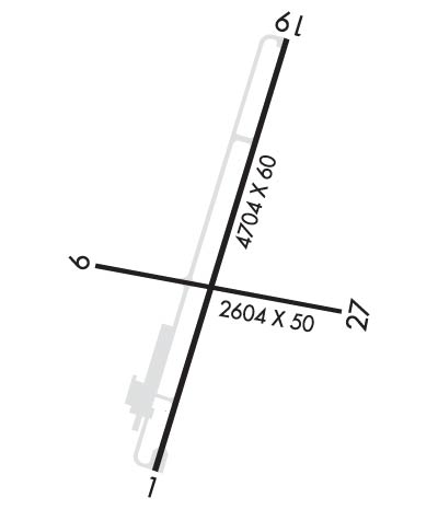
Runway Identifications
Runway Identification: 01/19Length: 4704 ft
Width: 60 ft
Surface: ASPHALT-FAIR CONDITION
Edge lights: Medium IntensityTreatment: NONE
Weight: PCN 4 /F/C/Y/T
| | Runway: 01 | | Runway: 19 |
| Mag heading: | 8° | Mag heading: | 188° |
| Rwy Slope: | .15% Up | Rwy Slope: | -.15% Down |
| Approach: | | Approach: | |
| Pattern: | Left Traffic | Pattern: | Left Traffic |
| Markings: | BASIC | Markings: | BASIC |
| Marking Condition: | FAIR | Marking Condition: | FAIR |
| Arresting Dev: | | Arresting Dev: | |
| Lat & Long: | N3207.5 W10309.4 | Lat. & Long.: | N3208.3 W10309.2 |
| Elev: | 3097.0 ft. MSL | Elev: | 3104.0 ft. MSL |
| TCH: | 40 ft. AGL | TCH: | 46 ft. AGL |
| Visual Glide Path: | 3.03 degrees | Visual Glide Path: | 2.83 degrees |
| Displaced Threshold: | No | Displaced Threshold: | No |
| Touchdown Zone: | YES | Touchdown Zone: | YES |
| Touchdown Elev.: | 3110.0 feet | Touchdown Elev.: | 3110.0 feet |
| Visual Glide Slope: | 2-Light PAPI on LEFT side of Runway | Visual Glide Slope: | 2-Light PAPI on LEFT side of Runway |
| RVR Equipment: | | RVR Equipment: | |
| RVV Equipment: | NO | RVV Equipment: | NO |
| Approach Lights: | | Approach Lights: | |
| REIL: | NO | REIL: | NO |
| Centerline Lights: | NO | Centerline Lights: | NO |
| Touchdown lights: | NO | Touchdown lights: | NO |
| Runway Category: | Runway with a Visual Approach | Runway Category: | Runway with a Visual Approach |
| Declared Distances: | | Declared Distances: | |
| Obstructions: | BRUSH | Obstructions: | BRUSH |
| Marked: | NOT Marked/Lighted | Marked: | NOT Marked/Lighted |
| Clearance slope: | | Clearance slope: | 8:1 |
| Obstruction height: | 3 feet AGL | Obstruction height: | 12 feet AGL |
| Dist. from runway: | 201 feet | Dist. from runway: | 300 feet |
| Centerline offset: | 120 right of centerline | Centerline offset: | 10 feet left of centerline |
| Comments: | +2-3 FT BRUSH 0-200 FT FM THR 115-250 FT R & 100 FT L OF CNTRLN. | Comments: | +1-2 FT BRUSH 0-200 FT FM THR 80 FT L OF CNTRLN. |
Runway Identification: 09/27Length: 2604 ft
Width: 50 ft
Surface: ASPHALT-GOOD CONDITION
Edge lights: Treatment: NONE
Weight: PCN 3 /F/B/Y/T
| | Runway: 09 | | Runway: 27 |
| Mag heading: | 92° | Mag heading: | 272° |
| Rwy Slope: | -.81% Down | Rwy Slope: | .81% Up |
| Approach: | | Approach: | |
| Pattern: | Left Traffic | Pattern: | Left Traffic |
| Markings: | BASIC | Markings: | BASIC |
| Marking Condition: | FAIR | Marking Condition: | FAIR |
| Arresting Dev: | | Arresting Dev: | |
| Lat & Long: | N3207.9 W10309.5 | Lat. & Long.: | N3207.8 W10309.0 |
| Elev: | 3118.0 ft. MSL | Elev: | 3097.0 ft. MSL |
| TCH: | | TCH: | |
| Visual Glide Path: | | Visual Glide Path: | |
| Displaced Threshold: | 40 feet | Displaced Threshold: | 45 feet |
| Touchdown Zone: | YES | Touchdown Zone: | YES |
| Touchdown Elev.: | 3118.0 feet | Touchdown Elev.: | 3118.0 feet |
| Visual Glide Slope: | | Visual Glide Slope: | |
| RVR Equipment: | | RVR Equipment: | |
| RVV Equipment: | NO | RVV Equipment: | NO |
| Approach Lights: | | Approach Lights: | |
| REIL: | NO | REIL: | NO |
| Centerline Lights: | NO | Centerline Lights: | NO |
| Touchdown lights: | NO | Touchdown lights: | NO |
| Runway Category: | Runway with a Visual Approach | Runway Category: | Runway with a Visual Approach |
| Declared Distances: | | Declared Distances: | |
| Obstructions: | BRUSH | Obstructions: | |
| Marked: | NOT Marked/Lighted | Marked: | |
| Clearance slope: | APCH SLOPE 4:1 TO DTHR DUE TO +10 FT ROAD 40 FT FM DTHR. | Clearance slope: | 20:1; APCH SLOPE 5:1 TO DTHR DUE TO +10 FT ROAD 65 FT FM DTHR. |
| Obstruction height: | 4 feet AGL | Obstruction height: | |
| Dist. from runway: | 201 feet | Dist. from runway: | |
| Centerline offset: | | Centerline offset: | |
| Comments: | +4 FT FENCE 50 FT FM THR; +10 FT ROAD 40 FT FM THR. | Comments: | +4 FT FENCE 15 FT FM RWY END; +5 FT BRUSH 20 FT FM RWY END; +10 FT ROAD 10 FT FM THR. |

