Click here for more info on on SMS!

KE24

WHITERIVER
WHITERIVER
AZ
Time Zone: Pacific
Lat: N 3348.6
Long: W 10959.1
Elev: 5153
Var: -12
Longest Runway: 6350
CTAF: 122.8

FBO & Flight Services info for KE24

FBOs: Update your Fuel Prices

AIRPORTPh: 928-338-5321
-
Freq: 122.8
Service
Jet
100LL
SAF
MoGas
Fuel Avail: NO FUEL AVAILABLE
Full        Last Update: 04/19/2024 00:01:45

Self        
If you are an FBO, call 1-203-262-1700 to update your info or email: FltPlan.Advertising@garmin.com
Advertise your FBO on FltPlan.com

Runway & Approach Info for KE24
Rwy
Length
Land Dist**
Approach*
  Rwy
Length
Land Dist**
Approach*
01
6350x75  6350'          
 
  
19
  6350x75  6100'          
 
 * only ILS, LOC, LDA, and SDF approaches to a specific runway are shown
** For any Declared Landing Distance Available, please see A/FD or Approach plates
Runway Weight Capability (lbs.) Help
Runway IDSingle WheelDouble WheelDouble Tandem WheelDual Double Wheel
01/1916,000N/AN/AN/A
These numbers are Advisory and are not limits.   The Airport Manager should have more accurate Weight Limits
Approach Charts
FltPlan does not have IFR approach charts available for KE24.
Current Weather/Notams
Customs Information Send updates to Support@FltPlan.com
Customs Not Available
Database effective 04/18/2024
Airport Diagram of KE24
Airport Diagram might not be current.

Facility Name: WHITERIVER
City Name: WHITERIVER
County: NAVAJO
State abbrev: AZ
State Name: ARIZONA
   
Ownership: PUBLICLY OWNED
Use: OPEN TO THE PUBLIC
Owner's Name: WHITE MTN APACHE TRIBE
Address: P.O.BOX 700
 WHITERIVER, AZ 85941
Owner's Phone: 928-338-4346
  
Manager's Name: LAREESA SANCHEZ
Address: P.O. BOX 1710
 WHITERIVER, AZ 85941
Phone: (928) 338-5155
   
FAA Region: WESTERN-PACIFIC
FAA Field Office: PHX


Sunrise / Sunset times for WHITERIVER

DateSunriseSunset
04/19/24 Friday5:4318:55
04/20/24 Saturday5:4218:56
04/21/24 Sunday5:4118:56
04/22/24 Monday5:4018:57
04/23/24 Tuesday5:3918:58
04/24/24 Wednesday5:3818:59
04/25/24 Thursday5:3718:59
04/26/24 Friday5:3519:00
04/27/24 Saturday5:3419:01
04/28/24 Sunday5:3319:02
04/29/24 Monday5:3219:03
04/30/24 Tuesday5:3119:03
05/01/24 Wednesday5:3019:04
05/02/24 Thursday5:2919:05

Airport Facilities

Airport Attendance ScheduleAPR-OCT MON-FRI 0700-1700, NOV-MAR MON-FRI 0800-1700
Airport Status OPERATIONAL (This Status can change at any time - please check NOTAMS)
Airport Lighting ScheduleACTVT REIL RWY 01 & 19; MIRL RWY 01/19 - CTAF.
Airport Storage AvailableTie Downs
Extra Services AvailableNONE
Wind IndicatorNONE
Control TowerNO
CTAF Frequency122.800
Unicom Frequency122.800
Rotating Beacon ColorWG
Segmented CircleNO
Landing FeeNO

Airport Inspection Data

Airport InspectedSTATE - performed by PRIVATE CONTRACT PERSONNEL
Inspection Date04/08/2021

Airport Services

Type of Fuel AvailableNone
Airframe Repair ServiceNone
Power Plant Repair ServiceNone

Geographic Data

LatitudeN3348.6
LongitudeW10959.1 (ESTIMATED)
Arpt Elevation5153ft (ESTIMATED)
Magnetic Variation12E
1 miles SWof WHITERIVER
Traffic Pattern Altitude
Sectional ChartPHOENIX

Aircraft Data

Operations (Reported)YearlyAvg. Daily
General Aviation Transient 30008
General Aviation Local 8502
Air Taxi 00
Commerical 00
Commuter 00
Military 600
Aircraft based on Field
General Aviation Singles 0
General Aviation Multi 0
Jet Aircraft 0
General Aviation Helicopters 0
Military Aircraft 0
Gliders 0
Ultralights 0

FAA Services

FSS on field NO
FSS tie-in PRESCOTT
FSS Phone 1-800-WX-BRIEF
Who issues Notams PRC
Notam D service at airport YES
ARTCC Name ALBUQUERQUE

Federal Status

Airport Certification
Aircraft Rescue & Firefighting IndexNone
Airport of EntryNo
Custom Landing RightsNo
Joint Civil/MilitaryNo
Military Landing rightsNo

Federal Agreements

NATIONAL PLAN OF INTEGRATED AIRPORT SYSTEMS (NPIAS)

Remarks

MTS ALL QUADS; HVY CANYON WINDS; MKD PWR LINES & WILDLIFE ON & INVOF ARPT.
FIRE SUPPRESSION OPS MAR-OCT.
ARPT GATE LOCKED.
FOR CD CTC ALBUQUERQUE ARTCC AT 505-856-4861.
RWY 01/1 9 SVRL LGTS OTS.
Runway Identifications
Runway Identification: 01/19
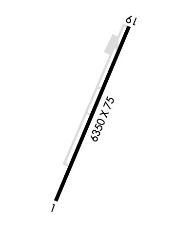
Length: 6350 ft
Width: 75 ft
Surface: ASPHALT-GOOD CONDITION
Edge lights: Medium Intensity

Treatment: NONE

 Runway: 01   Runway: 19
Mag heading: 18°Mag heading: 198°
Rwy Slope: 1.17% UpRwy Slope: -1.17% Down
Approach: Approach:
Pattern: Right TrafficPattern: Left Traffic
Markings: NONPRECISION INSTRUMENTMarkings: NONPRECISION INSTRUMENT
Marking Condition: FAIRMarking Condition: FAIR
Arresting Dev: Arresting Dev:
Lat & Long: N3348.2  W10959.5Lat. & Long.: N3349.1  W10958.8
Elev: 5078.9 ft. MSLElev: 5152.9 ft. MSL
TCH: 40 ft. AGLTCH:
Visual Glide Path: 3.00 degreesVisual Glide Path:
Displaced Threshold: NoDisplaced Threshold: 250 feet
Touchdown Zone: YESTouchdown Zone: YES
Touchdown Elev.: 5098.0 feetTouchdown Elev.: 5149.0 feet
Visual Glide Slope: 2-Light PAPI on LEFT side of Runway; PAPI OTS INDEF.Visual Glide Slope:
RVR Equipment: RVR Equipment:
RVV Equipment: NORVV Equipment: NO
Approach Lights: Approach Lights:
REIL: YES; REIL OTS INDEF.REIL: YES
Centerline Lights: NOCenterline Lights: NO
Touchdown lights: NOTouchdown lights: NO
Runway Category: Runway with a Visual ApproachRunway Category: Runway with a Visual Approach
Declared Distances: TORA:6100' TODA:6350' ASDA:6100' LDA:6100'Declared Distances: TORA:6350' TODA:6350' ASDA:6350' LDA:6100'
Obstructions: Obstructions: GND
Marked: Marked: NOT Marked/Lighted
Clearance slope: 50:1Clearance slope: APCH RATIO 20:1 TO DTHLD.
Obstruction height: Obstruction height: 8 feet AGL
Dist. from runway: Dist. from runway: 201 feet
Centerline offset: Centerline offset: 250 feet right of centerline
Comments: 3 FT BRUSH & WEEDS 0-200 FT FM THR; ACRS THR AREA.Comments: +10 FT ROAD 0-150 FT FM THR BOTH SIDES; 12 FT TREE 125 FT FM THR 115 FT L; +10 FT BRUSH 140 FT FM THR 80 FT L OF CNTRLN; 0-8 FT BERM 0-200 FT FM THR 50-250 FT R OF CNTRLN.
C:/P: