
| ||||||||||||||||||||||||||||||||||||||||||||
| ||||||||||||||||||||||||||||||||||||||||||||
| ||||||||||||||||||||||||||||||||||||||||||||
| ||||||||||||||||||||||||||||||||||||||||||||
| ||||||||||||||||||||||||||||||||||||||||||||
| ||||||||||||||||||||||||||||||||||||||||||||
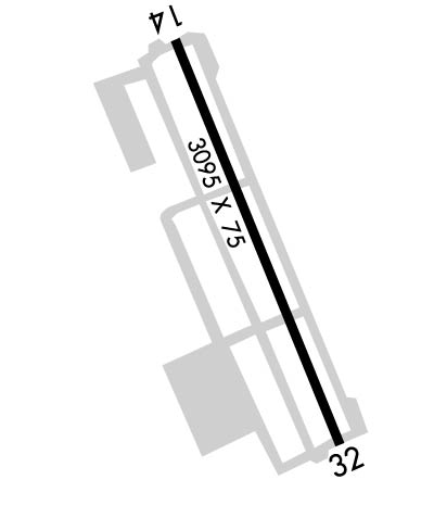
| Rwy | Rwy | |||||||
| 3095x75 | 3095' | 3095x75 | 3095' | |||||
| Runway ID | Single Wheel | Double Wheel | Double Tandem Wheel | Dual Double Wheel |
| 14/32 | 12,500 | N/A | N/A | N/A |
| These numbers are Advisory and are not limits. The Airport Manager should have more accurate Weight Limits | ||||
 Airport Diagram might not be current. | |
| Facility Name: | SAN MARTIN |
| City Name: | SAN MARTIN |
| County: | SANTA CLARA |
| State abbrev: | CA |
| State Name: | CALIFORNIA |
| Ownership: | PUBLICLY OWNED |
| Use: | OPEN TO THE PUBLIC |
| Owner's Name: | COUNTY OF SANTA CLARA |
| Address: | 2500 CUNNINGHAM AVE. |
| SAN JOSE, CA 95148 | |
| Owner's Phone: | 408-918-7700; ERIC PETERSON, DIRECTOR OF AIRPORTS. |
| Manager's Name: | ERIC PETERSON |
| Address: | 2500 CUNNINGHAM |
| SAN JOSE, CA 95046 | |
| Phone: | 408-918-7700 |
| FAA Region: | WESTERN-PACIFIC |
| FAA Field Office: | SFO |
| Date | Sunrise | Sunset |
|---|---|---|
| 04/22/24 Monday | 6:22 | 19:48 |
| 04/23/24 Tuesday | 6:20 | 19:49 |
| 04/24/24 Wednesday | 6:19 | 19:50 |
| 04/25/24 Thursday | 6:18 | 19:51 |
| 04/26/24 Friday | 6:17 | 19:52 |
| 04/27/24 Saturday | 6:16 | 19:53 |
| 04/28/24 Sunday | 6:14 | 19:54 |
| 04/29/24 Monday | 6:13 | 19:55 |
| 04/30/24 Tuesday | 6:12 | 19:55 |
| 05/01/24 Wednesday | 6:11 | 19:56 |
| 05/02/24 Thursday | 6:10 | 19:57 |
| 05/03/24 Friday | 6:09 | 19:58 |
| 05/04/24 Saturday | 6:08 | 19:59 |
| 05/05/24 Sunday | 6:07 | 20:00 |
| Airport Attendance Schedule | WED-THU 1000-1700 |
| Airport Status | OPERATIONAL (This Status can change at any time - please check NOTAMS) |
| Airport Lighting Schedule | ACTVT MIRL RWY 14/32 - CTAF. PAPI RWYS 14 & 32 ON CONTINUOUSLY.; DUSK-DAWN. |
| Airport Storage Available | Tie Downs, Hanger |
| Extra Services Available | Charter, Flight Instruction, Parachute Jumping, Aircraft Rental, Aircraft Sales |
| Wind Indicator | YES - (lighted) |
| Control Tower | NO |
| CTAF Frequency | 122.700 |
| Unicom Frequency | 122.700 |
| Rotating Beacon Color | WG |
| Segmented Circle | YES |
| Landing Fee | NO |
| Airport Inspected | STATE - performed by STATE AERONAUTICAL PERSONNEL |
| Inspection Date | 08/31/2023 |
| Type of Fuel Available | JET A (freeze point -40C)UL94; -ULBGNG JANUARY 1, 2022 100LL UNAVBL. |
| Airframe Repair Service | MAJOR |
| Power Plant Repair Service | MAJOR |
| Latitude | N3704.9 |
| Longitude | W12135.8 (ESTIMATED) |
| Arpt Elevation | 283ft (SURVEYED) |
| Magnetic Variation | 15E |
| 1 miles E | of SAN MARTIN |
| Traffic Pattern Altitude | |
| Sectional Chart | SAN FRANCISCO |
| Operations (Reported) | Yearly | Avg. Daily |
|---|---|---|
| General Aviation Transient | 16900 | 46 |
| General Aviation Local | 16266 | 45 |
| Air Taxi | 0 | 0 |
| Commerical | 0 | 0 |
| Commuter | 0 | 0 |
| Military | 0 | 0 |
| Aircraft based on Field | |
|---|---|
| General Aviation Singles | 29 |
| General Aviation Multi | 4 |
| Jet Aircraft | 0 |
| General Aviation Helicopters | 1 |
| Military Aircraft | 0 |
| Gliders | 0 |
| Ultralights | 0 |
| FSS on field | NO |
| FSS tie-in | OAKLAND |
| FSS Phone | 1-800-WX-BRIEF |
| Who issues Notams | E16 |
| Notam D service at airport | YES |
| ARTCC Name | OAKLAND |
| Airport Certification | |
| Aircraft Rescue & Firefighting Index | None |
| Airport of Entry | No |
| Custom Landing Rights | No |
| Joint Civil/Military | No |
| Military Landing rights | YES |
| NATIONAL PLAN OF INTEGRATED AIRPORT SYSTEMS (NPIAS) |
| GRANT AGREEMENTS UNDER FAAP/ADAP/AIP |
| ASSURANCES PURSUANT TO TITLE VI, CIVIL RIGHTS ACT OF 1964 |
| NO CROSSWIND TURNS BLO 1300 FT MSL; DEPS CLIMB TO 2000 FT MSL. |
| APCHG ACFT FLY DOWNWIND LEGS E OF FREEWAY. |
| FOR CD CTC NORCAL APCH AT 916-361-3748. |
Airport Communications & Frequencies:
| ||||||||||||||
| Runway: 14 | Runway: 32 | ||
| Mag heading: | 141° | Mag heading: | 321° |
| Rwy Slope: | -.34% Down | Rwy Slope: | .34% Up |
| Approach: | Approach: | ||
| Pattern: | Left Traffic | Pattern: | Right Traffic |
| Markings: | NONPRECISION INSTRUMENT | Markings: | NONPRECISION INSTRUMENT |
| Marking Condition: | GOOD | Marking Condition: | GOOD |
| Arresting Dev: | Arresting Dev: | ||
| Lat & Long: | N3705.1 W12135.9 | Lat. & Long.: | N3704.7 W12135.7 |
| Elev: | 283.6 ft. MSL | Elev: | 273.1 ft. MSL |
| TCH: | 41 ft. AGL | TCH: | 42 ft. AGL |
| Visual Glide Path: | 4.00 degrees | Visual Glide Path: | 4.00 degrees |
| Displaced Threshold: | No | Displaced Threshold: | No |
| Touchdown Zone: | YES | Touchdown Zone: | YES |
| Touchdown Elev.: | 283.8 feet | Touchdown Elev.: | 283.5 feet |
| Visual Glide Slope: | 2-Light PAPI on LEFT side of Runway | Visual Glide Slope: | 2-Light PAPI on LEFT side of Runway |
| RVR Equipment: | RVR Equipment: | ||
| RVV Equipment: | NO | RVV Equipment: | NO |
| Approach Lights: | Approach Lights: | ||
| REIL: | NO | REIL: | NO |
| Centerline Lights: | NO | Centerline Lights: | NO |
| Touchdown lights: | NO | Touchdown lights: | NO |
| Runway Category: | Runway with a Visual Approach | Runway Category: | Runway with a Non-precision Approach |
| Declared Distances: | Declared Distances: | ||
| Obstructions: | POLE | Obstructions: | TREE |
| Marked: | NOT Marked/Lighted | Marked: | NOT Marked/Lighted |
| Clearance slope: | 21:1 | Clearance slope: | 26:1 |
| Obstruction height: | 41 feet AGL | Obstruction height: | 32 feet AGL |
| Dist. from runway: | 1100 feet | Dist. from runway: | 1040 feet |
| Centerline offset: | 200 right of centerline | Centerline offset: | 73 feet right of centerline |
| Comments: | Comments: |
