Current Weather/Notams (Metars, TAFs, Notams, NWS Forecast, PIREPS, and nearby weather)
Customs Information Send updates to Support@FltPlan.com
Customs Not Available
Database effective 04/18/2024
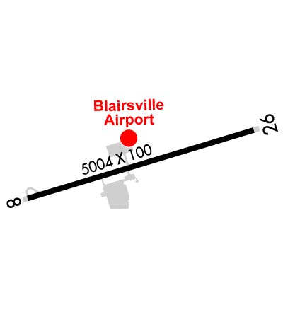
Airport Diagram might not be current. Facility Name: BLAIRSVILLE City Name: BLAIRSVILLE County: UNION State abbrev: GA State Name: GEORGIA Ownership: PUBLICLY OWNED Use: OPEN TO THE PUBLIC Owner's Name: CITY OF BLAIRSVILLE Address: P.O. BOX 307, 62 BLUE RIDGE STREET, 33 BLUERIDGE STREET BLAIRSVILLE, GA 30512 Owner's Phone: 706-745-2000 Manager's Name: AARON MANNHEIM Address: 579 AIRPORT TERMINAL DRIVE BLAIRSVILLE, GA 30512 Phone: 706-745-4307 FAA Region: SOUTHERN FAA Field Office: ATL
Runway Identifications Help
Runway Identification: 08/26 Length: 5004 ftWidth: 100 ftSurface: ASPHALT-GOOD CONDITIONEdge lights: Medium Intensity Treatment: NONE Runway: 08 Runway: 26 Mag heading: 76° Mag heading: 256° Rwy Slope: -1.03% Down Rwy Slope: 1.03% Up Approach: Approach: Pattern: Left Traffic Pattern: Left Traffic Markings: NONPRECISION INSTRUMENT Markings: NONPRECISION INSTRUMENT Marking Condition: GOOD Marking Condition: GOOD Arresting Dev: Arresting Dev: Lat & Long: N3451.1 W08400.3 Lat. & Long.: N3451.4 W08359.4 Elev: 1907.1 ft. MSL Elev: 1855.5 ft. MSL TCH: 40 ft. AGL TCH: 56 ft. AGL Visual Glide Path: 3.31 degrees Visual Glide Path: 3.54 degrees Displaced Threshold: 986 feet Displaced Threshold: 685 feet Touchdown Zone: YES Touchdown Zone: YES Touchdown Elev.: 1900.7 feet Touchdown Elev.: 1897.7 feet Visual Glide Slope: 2-Light PAPI on LEFT side of Runway Visual Glide Slope: 2-Light PAPI on LEFT side of Runway; UNUSBL BYD 1.3 NM DUE TO TRRN. RVR Equipment: RVR Equipment: RVV Equipment: NO RVV Equipment: NO Approach Lights: Approach Lights: REIL: NO REIL: NO Centerline Lights: NO Centerline Lights: NO Touchdown lights: NO Touchdown lights: NO Runway Category: Runway with a Non-precision Approach having visibility minimums greater than 3/4 mile Runway Category: Runway with a Visual Approach Declared Distances: TORA:5004' TODA:5004' ASDA:5004' LDA:4018' Declared Distances: TORA:5004' TODA:5004' ASDA:5004' LDA:4319' Obstructions: TREES Obstructions: TREES Marked: NOT Marked/Lighted Marked: NOT Marked/Lighted Clearance slope: 4:1; APCH RATIO 15:1 TO DSPLCD THR; 177 FT TREES 2653 FT FM DSPLCD THR 451 FT LEFT. Clearance slope: Obstruction height: 67 feet AGL Obstruction height: 30 feet AGL Dist. from runway: 507 feet Dist. from runway: 201 feet Centerline offset: 291 left of centerline Centerline offset: 155 feet left of centerline Comments: Comments: RWY 26 +10 FT-13 FT HILL 135 FT-250 FT L&R, 20 FT TREES 147 FT LEFT 0 FT-200 FT FM E.O.R.