Current Weather/Notams (Metars, TAFs, Notams, NWS Forecast, PIREPS, and nearby weather)
Customs Information Send updates to Support@FltPlan.com
Customs Not Available
Database effective 04/18/2024
Airport Diagram might not be current.
|
| Facility Name: | DYERSBURG RGNL |
| City Name: | DYERSBURG |
| County: | DYER |
| State abbrev: | TN |
| State Name: | TENNESSEE |
| | |
| Ownership: | PUBLICLY OWNED |
| Use: | OPEN TO THE PUBLIC |
| Owner's Name: | CITY OF DYERSBURG |
| Address: | CITY HALL, PO BOX 1358 |
| | DYERSBURG, TN 38024 |
| Owner's Phone: | (731) 288-7600 |
| | |
| Manager's Name: | DIAN DAWSON |
| Address: | 315 AIRPORT ROAD |
| | DYERSBURG, TN 38024 |
| Phone: | 731-445-3979 |
| | |
| FAA Region: | SOUTHERN |
| FAA Field Office: | MEM |
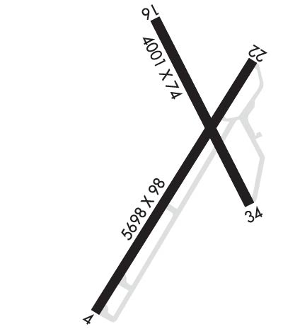
Runway Identifications
Runway Identification: 04/22Length: 5698 ft
Width: 98 ft
Surface: ASPHALT-GOOD CONDITION
Edge lights: Medium IntensityTreatment: NONE
Weight: PCN 9 /F/D/X/T
| | Runway: 04 | | Runway: 22 |
| Mag heading: | 41° | Mag heading: | 222° |
| Rwy Slope: | .76% Up | Rwy Slope: | -.76% Down |
| Approach: | | Approach: | |
| Pattern: | Left Traffic | Pattern: | Left Traffic |
| Markings: | NONPRECISION INSTRUMENT | Markings: | NONPRECISION INSTRUMENT |
| Marking Condition: | GOOD | Marking Condition: | GOOD |
| Arresting Dev: | | Arresting Dev: | |
| Lat & Long: | N3559.4 W08924.8 | Lat. & Long.: | N3600.1 W08924.1 |
| Elev: | 291.5 ft. MSL | Elev: | 334.6 ft. MSL |
| TCH: | 35 ft. AGL | TCH: | 28 ft. AGL |
| Visual Glide Path: | 3.00 degrees | Visual Glide Path: | 3.00 degrees |
| Displaced Threshold: | No | Displaced Threshold: | 694 feet |
| Touchdown Zone: | YES | Touchdown Zone: | YES |
| Touchdown Elev.: | 316.1 feet | Touchdown Elev.: | 333.9 feet |
| Visual Glide Slope: | 4-Light PAPI on LEFT side of Runway | Visual Glide Slope: | 4-Light PAPI on LEFT side of Runway |
| RVR Equipment: | | RVR Equipment: | |
| RVV Equipment: | NO | RVV Equipment: | NO |
| Approach Lights: | | Approach Lights: | |
| REIL: | YES | REIL: | YES |
| Centerline Lights: | NO | Centerline Lights: | NO |
| Touchdown lights: | NO | Touchdown lights: | NO |
| Runway Category: | Runway with a Non-precision Approach having visibility minimums greater than 3/4 mile | Runway Category: | Runway with a Non-precision Approach having visibility minimums greater than 3/4 mile |
| Declared Distances: | | Declared Distances: | |
| Obstructions: | TREES | Obstructions: | TREES |
| Marked: | NOT Marked/Lighted | Marked: | NOT Marked/Lighted |
| Clearance slope: | 22:1 | Clearance slope: | 12:1 |
| Obstruction height: | 57 feet AGL | Obstruction height: | 47 feet AGL |
| Dist. from runway: | 1478 feet | Dist. from runway: | 780 feet |
| Centerline offset: | 371 left of centerline | Centerline offset: | 371 feet right of centerline |
| Comments: | | Comments: | |
Runway Identification: 16/34Length: 4001 ft
Width: 74 ft
Surface: ASPHALT-POOR CONDITION
Edge lights: Treatment: NONE
| | Runway: 16 | | Runway: 34 |
| Mag heading: | 163° | Mag heading: | 343° |
| Rwy Slope: | -.31% Down | Rwy Slope: | .31% Up |
| Approach: | | Approach: | |
| Pattern: | Left Traffic | Pattern: | Left Traffic |
| Markings: | BASIC | Markings: | BASIC |
| Marking Condition: | FAIR | Marking Condition: | FAIR |
| Arresting Dev: | | Arresting Dev: | |
| Lat & Long: | N3600.3 W08924.4 | Lat. & Long.: | N3559.7 W08924.2 |
| Elev: | 337.7 ft. MSL | Elev: | 325.3 ft. MSL |
| TCH: | | TCH: | |
| Visual Glide Path: | | Visual Glide Path: | |
| Displaced Threshold: | No | Displaced Threshold: | No |
| Touchdown Zone: | YES | Touchdown Zone: | YES |
| Touchdown Elev.: | 337.7 feet | Touchdown Elev.: | 337.7 feet |
| Visual Glide Slope: | | Visual Glide Slope: | |
| RVR Equipment: | | RVR Equipment: | |
| RVV Equipment: | NO | RVV Equipment: | NO |
| Approach Lights: | | Approach Lights: | |
| REIL: | NO | REIL: | NO |
| Centerline Lights: | NO | Centerline Lights: | NO |
| Touchdown lights: | NO | Touchdown lights: | NO |
| Runway Category: | Runway with a Visual Approach | Runway Category: | Runway with a Visual Approach |
| Declared Distances: | | Declared Distances: | |
| Obstructions: | TREE | Obstructions: | TREE |
| Marked: | NOT Marked/Lighted | Marked: | NOT Marked/Lighted |
| Clearance slope: | 27:1 | Clearance slope: | 7:1 |
| Obstruction height: | 27 feet AGL | Obstruction height: | 78 feet AGL |
| Dist. from runway: | 947 feet | Dist. from runway: | 816 feet |
| Centerline offset: | 292 left of centerline | Centerline offset: | 355 feet left of centerline |
| Comments: | | Comments: | |

