Click here for more info on on SMS!

KDYB

SUMMERVILLE
SUMMERVILLE
SC
Time Zone: Eastern
Lat: N 3303.7
Long: W 08016.9
Elev: 56
Var: +07
Longest Runway: 5000
AWOS: 119.57
CTAF: 123.0

FBO & Flight Services info for KDYB

FBOs: Update your Fuel Prices
Providing high quality fuel and services to you and your customers, from Phillips 66 Aviation.
Ph: 843-851-0970 Fax: 843-851-0971 Freq: 123.0Website-
Service
Jet
100LL
SAF
MoGas
Fuel Avail: All taxes included
Full6.106.60    Last Update: 04/15/2024 11:40

Self        
Misc. Info: Address: 890 GREYBACK RD   SUMMERVILLE, SC 29483

AWOSPh: 843-821-8403
-
Freq: 119.57  
If you are an FBO, call 1-203-262-1700 to update your info or email: FltPlan.Advertising@garmin.com
Advertise your FBO on FltPlan.com

Runway & Approach Info for KDYB
Rwy
Length
Land Dist**
Approach*
  Rwy
Length
Land Dist**
Approach*
06
5000x75  5000'          
 
  
24
  5000x75  5000'          
 
 * only ILS, LOC, LDA, and SDF approaches to a specific runway are shown
** For any Declared Landing Distance Available, please see A/FD or Approach plates
Runway Weight Capability (lbs.) Help
Runway IDSingle WheelDouble WheelDouble Tandem WheelDual Double Wheel
06/2419,50031,000N/AN/A
These numbers are Advisory and are not limits.   The Airport Manager should have more accurate Weight Limits
Approach Charts
Approaches    
Current Weather/Notams
Customs Information Send updates to Support@FltPlan.com
Customs Not Available
Database effective 04/18/2024
Airport Diagram of KDYB
Airport Diagram might not be current.

Facility Name: SUMMERVILLE
City Name: SUMMERVILLE
County: DORCHESTER
State abbrev: SC
State Name: SOUTH CAROLINA
   
Ownership: PUBLICLY OWNED
Use: OPEN TO THE PUBLIC
Owner's Name: DORCHESTER COUNTY
Address: BOX 416
 ST. GEORGE, SC 29477
Owner's Phone: 843-563-0100
  
Manager's Name: DON HAY
Address: PO BOX 347, P.O. BOX 3
 HARLEYVILLE, SC 29448
Phone: 843-412-1999
   
FAA Region: SOUTHERN
FAA Field Office: ATL


Sunrise / Sunset times for SUMMERVILLE

DateSunriseSunset
04/17/24 Wednesday6:4819:54
04/18/24 Thursday6:4719:54
04/19/24 Friday6:4619:55
04/20/24 Saturday6:4419:56
04/21/24 Sunday6:4319:57
04/22/24 Monday6:4219:57
04/23/24 Tuesday6:4119:58
04/24/24 Wednesday6:4019:59
04/25/24 Thursday6:3919:59
04/26/24 Friday6:3820:00
04/27/24 Saturday6:3720:01
04/28/24 Sunday6:3620:02
04/29/24 Monday6:3520:02
04/30/24 Tuesday6:3420:03

Airport Facilities

Airport Attendance Schedule7 Days A Week 0800-1900
Airport Status OPERATIONAL (This Status can change at any time - please check NOTAMS)
Airport Lighting ScheduleMIRL RY 06/24 OPER DUSK-2200; AFTER 2200 ACTVT - CTAF.
Airport Storage AvailableTie Downs
Extra Services AvailableFlight Instruction
Wind IndicatorYES - (lighted)
Control TowerNO
CTAF Frequency123.000
Unicom Frequency123.000
Rotating Beacon ColorWG
Segmented CircleYES
Landing Fee

Airport Inspection Data

Airport InspectedSTATE - performed by STATE AERONAUTICAL PERSONNEL
Inspection Date05/23/2023

Airport Services

Type of Fuel AvailableGrade 100LL, JET A (freeze point -40C)
Airframe Repair ServiceMAJOR
Power Plant Repair ServiceMAJOR

Geographic Data

LatitudeN3303.7
LongitudeW08016.9 (ESTIMATED)
Arpt Elevation55ft (SURVEYED)
Magnetic Variation07W
5 miles NWof SUMMERVILLE
Traffic Pattern Altitude
Sectional ChartCHARLOTTE

Aircraft Data

Operations (Reported)YearlyAvg. Daily
General Aviation Transient 390911
General Aviation Local 426912
Air Taxi 8222
Commerical 00
Commuter 00
Military 2501
Aircraft based on Field
General Aviation Singles 68
General Aviation Multi 9
Jet Aircraft 0
General Aviation Helicopters 0
Military Aircraft 0
Gliders 0
Ultralights 0

FAA Services

FSS on field NO
FSS tie-in ANDERSON
FSS Phone 1-800-WX-BRIEF
Who issues Notams AND
Notam D service at airport YES
ARTCC Name JACKSONVILLE

Federal Status

Airport Certification
Aircraft Rescue & Firefighting IndexNone
Airport of EntryNo
Custom Landing RightsNo
Joint Civil/MilitaryNo
Military Landing rightsNo

Federal Agreements

NATIONAL PLAN OF INTEGRATED AIRPORT SYSTEMS (NPIAS)
GRANT AGREEMENTS UNDER FAAP/ADAP/AIP
ASSURANCES PURSUANT TO TITLE VI, CIVIL RIGHTS ACT OF 1964

Remarks

FOR FBO CALL (843) 851-0970.
BANNER TOWING 1500/BLO INTMT DAILY, SOUTH SIDE RY 06/24.
FOR CD CTC CHARLESTON APCH AT 843-414-2832.
Airport Communications & Frequencies:
CTAF Frequency:
123.000
Unicom Frequency:
123.000
CHARLESTON Primary Approach Frequencies:  
120.7
306.925
CHARLESTON Primary Departure Frequencies:  
120.7
306.925
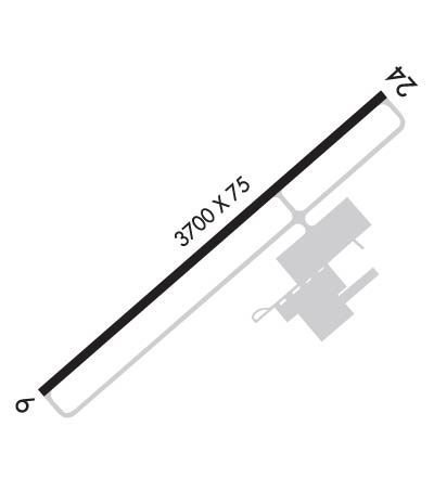
Runway Identifications
Runway Identification: 06/24
Length: 5000 ft
Width: 75 ft
Surface: ASPHALT-GOOD CONDITION
Edge lights: Medium Intensity

Treatment: NONE
Weight: PCN 7 /F/C/X/T

 Runway: 06   Runway: 24
Mag heading: 56°Mag heading: 236°
Rwy Slope: .30% UpRwy Slope: -.30% Down
Approach: Approach:
Pattern: Right TrafficPattern: Left Traffic
Markings: NONPRECISION INSTRUMENTMarkings: NONPRECISION INSTRUMENT
Marking Condition: GOODMarking Condition: GOOD
Arresting Dev: Arresting Dev:
Lat & Long: N3303.5  W08017.2Lat. & Long.: N3304.0  W08016.5
Elev: 38.4 ft. MSLElev: 53.5 ft. MSL
TCH: TCH:
Visual Glide Path: Visual Glide Path:
Displaced Threshold: NoDisplaced Threshold: No
Touchdown Zone: YESTouchdown Zone: YES
Touchdown Elev.: 52.6 feetTouchdown Elev.: 55.8 feet
Visual Glide Slope: Visual Glide Slope:
RVR Equipment: RVR Equipment:
RVV Equipment: NORVV Equipment: NO
Approach Lights: Approach Lights:
REIL: NOREIL: NO
Centerline Lights: NOCenterline Lights: NO
Touchdown lights: NOTouchdown lights: NO
Runway Category: Runway with a Non-precision Approach having visibility minimums greater than 3/4 mileRunway Category: Runway with a Non-precision Approach having visibility minimums greater than 3/4 mile
Declared Distances: Declared Distances:
Obstructions: TREESObstructions: TREE
Marked: NOT Marked/LightedMarked: NOT Marked/Lighted
Clearance slope: 34:1Clearance slope: 18:1
Obstruction height: Obstruction height: 75 feet AGL
Dist. from runway: Dist. from runway: 1560 feet
Centerline offset: Centerline offset: 221 feet right of centerline
Comments: Comments:
C:6/P: