Current Weather/Notams (Metars, TAFs, Notams, NWS Forecast, PIREPS, and nearby weather)
Customs Information Send updates to Support@FltPlan.com
Customs Not Available
Database effective 04/18/2024
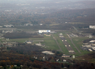
Airport Diagram might not be current. Facility Name: DANBURY MUNI City Name: DANBURY County: FAIRFIELD State abbrev: CT State Name: CONNECTICUT Ownership: PUBLICLY OWNED Use: OPEN TO THE PUBLIC Owner's Name: CITY OF DANBURY Address: CITY HALL, 115 DEER HILL DR. DANBURY, CT 06810 Owner's Phone: 203-797-4624 Manager's Name: MICHAEL SAFRANEK Address: P.O.BOX 2299 DANBURY, CT 06813 Phone: 203-797-4624 FAA Region: NEW ENGLAND FAA Field Office: NONE
Runway Identifications Help
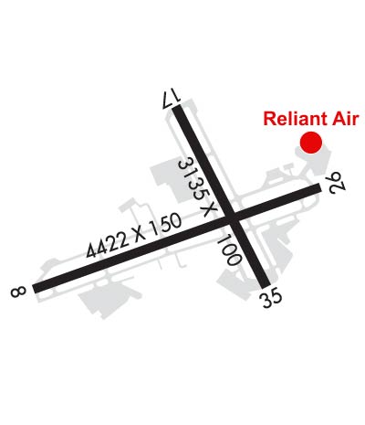
Runway Identification: 08/26 Length: 4421 ftWidth: 150 ftSurface: ASPHALT-GOOD CONDITIONEdge lights: Medium Intensity Treatment: GROOVED Runway: 08 Runway: 26 Mag heading: 84° Mag heading: 264° Rwy Slope: -.08% Down Rwy Slope: .08% Up Approach: LOC/DME Approach: Pattern: Left Traffic Pattern: Left Traffic Markings: NONPRECISION INSTRUMENT Markings: NONPRECISION INSTRUMENT Marking Condition: GOOD Marking Condition: GOOD Arresting Dev: Arresting Dev: Lat & Long: N4122.1 W07329.4 Lat. & Long.: N4122.4 W07328.5 Elev: 456.6 ft. MSL Elev: 453.1 ft. MSL TCH: TCH: Visual Glide Path: Visual Glide Path: Displaced Threshold: 367 feet Displaced Threshold: 734 feet Touchdown Zone: YES Touchdown Zone: YES Touchdown Elev.: 456.6 feet Touchdown Elev.: 456.4 feet Visual Glide Slope: Visual Glide Slope: RVR Equipment: RVR Equipment: RVV Equipment: NO RVV Equipment: NO Approach Lights: Approach Lights: REIL: YES REIL: YES Centerline Lights: NO Centerline Lights: NO Touchdown lights: NO Touchdown lights: NO Runway Category: Runway with a Non-precision Approach Runway Category: Runway with a Non-precision Approach Declared Distances: Declared Distances: Obstructions: TREES Obstructions: TREES Marked: NOT Marked/Lighted Marked: NOT Marked/Lighted Clearance slope: 2:1; APCH RATIO 12:1 BASED ON DSPLCD THR. Clearance slope: 3:1; APCH RATIO 11:1 TO DSPLCD THR. Obstruction height: 15 feet AGL Obstruction height: 88 feet AGL Dist. from runway: 230 feet Dist. from runway: 450 feet Centerline offset: 75 left of centerline Centerline offset: 100 feet right of centerline Comments: +9 FT FENCE 170 FT FM THR. Comments: +6 FT FENCE 75 FT FM THR.
Runway Identification: 17/35 Length: 3135 ftWidth: 100 ftSurface: ASPHALT-GOOD CONDITIONEdge lights: Treatment: NONE Runway: 17 Runway: 35 Mag heading: 167° Mag heading: 347° Rwy Slope: .06% Up Rwy Slope: -.06% Down Approach: Approach: Pattern: Left Traffic Pattern: Left Traffic Markings: BASIC Markings: BASIC Marking Condition: GOOD Marking Condition: GOOD Arresting Dev: Arresting Dev: Lat & Long: N4122.6 W07329.0 Lat. & Long.: N4122.1 W07328.7 Elev: 451.5 ft. MSL Elev: 453.3 ft. MSL TCH: TCH: Visual Glide Path: Visual Glide Path: Displaced Threshold: 223 feet Displaced Threshold: 231 feet Touchdown Zone: YES Touchdown Zone: YES Touchdown Elev.: 453.5 feet Touchdown Elev.: 453.5 feet Visual Glide Slope: Visual Glide Slope: RVR Equipment: RVR Equipment: RVV Equipment: NO RVV Equipment: NO Approach Lights: Approach Lights: REIL: NO REIL: NO Centerline Lights: NO Centerline Lights: NO Touchdown lights: NO Touchdown lights: NO Runway Category: Runway with a Visual Approach Runway Category: Runway with a Visual Approach Declared Distances: Declared Distances: Obstructions: POLE Obstructions: TREES Marked: NOT Marked/Lighted Marked: NOT Marked/Lighted Clearance slope: 18:1; APCH RATIO 28:1 TO DSPLCD THR. Clearance slope: 5:1; APCH RATIO 19:1 TO DSPLCD THR. Obstruction height: 22 feet AGL Obstruction height: 30 feet AGL Dist. from runway: 600 feet Dist. from runway: 350 feet Centerline offset: 150 left of centerline Centerline offset: 100 feet right of centerline Comments: 5 FT FENCE 50 FT FM THR; +15 FT ROAD 94 FT FM THR. Comments: +8 FT FENCE 150 FT FM THR; +17 FT ROAD 120 FT FM THR.