Click here for more info on on SMS!

KDWU

ASHLAND RGNL
ASHLAND
KY
Time Zone: Eastern
Lat: N 3833.3
Long: W 08244.3
Elev: 547
Var: +05
Longest Runway: 5402
Clr Del: 121.7
AWOS: 132.42
CTAF: 122.8

FBO & Flight Services info for KDWU

FBOs: Update your Fuel Prices

ASHLAND REGIONALPh: 606-494-2034 Fax: 606-494-2037 Freq: 122.8
Service
Jet
100LL
SAF
MoGas
Fuel Avail: PRIST+ $0.10/gal. ALL TXS INCLUDED. Full Time With After hours Self-Serve(100LL Only)
Full5.606.50    Last Update: 04/19/2024 13:33

Self5.606.50    
 Address: 501 SCOTT STREET   WORTHINGTON, KY 41183
AWOSPh: 606-836-2682
-
Freq: 132.42  
If you are an FBO, call 1-203-262-1700 to update your info or email: FltPlan.Advertising@garmin.com
Advertise your FBO on FltPlan.com

Runway & Approach Info for KDWU
Rwy
Length
Land Dist**
Approach*
  Rwy
Length
Land Dist**
Approach*
10
5402x100  5402'          
 
  
28
  5402x100  5402'          
 
 * only ILS, LOC, LDA, and SDF approaches to a specific runway are shown
** For any Declared Landing Distance Available, please see A/FD or Approach plates
Runway Weight Capability (lbs.) Help
Runway IDSingle WheelDouble WheelDouble Tandem WheelDual Double Wheel
10/2850,50072,000105,000N/A
These numbers are Advisory and are not limits.   The Airport Manager should have more accurate Weight Limits
Approach Charts
Approaches    
Current Weather/Notams
Customs Information Send updates to Support@FltPlan.com
Customs Not Available
Database effective 05/16/2024
Airport Diagram of KDWU
Airport Diagram might not be current.

Facility Name: ASHLAND RGNL
City Name: ASHLAND
County: GREENUP
State abbrev: KY
State Name: KENTUCKY
   
Ownership: PUBLICLY OWNED
Use: OPEN TO THE PUBLIC
Owner's Name: ASHLAND REGIONAL AIRPORT BOARD; DAVID MANSFIELD
Address: 501 SCOTT ST
 WORTHINGTON, KY 41183
Owner's Phone: (606) 232-1469
  
Manager's Name: JOHN STINES
Address: 501 SCOTT ST
 WORTHINGTON, KY 41183
Phone: (606) 858-2849
   
FAA Region: SOUTHERN
FAA Field Office: MEM


Sunrise / Sunset times for ASHLAND RGNL

DateSunriseSunset
04/25/24 Thursday6:4020:18
04/26/24 Friday6:3920:19
04/27/24 Saturday6:3820:20
04/28/24 Sunday6:3620:21
04/29/24 Monday6:3520:22
04/30/24 Tuesday6:3420:23
05/01/24 Wednesday6:3320:24
05/02/24 Thursday6:3220:25
05/03/24 Friday6:3120:25
05/04/24 Saturday6:2920:26
05/05/24 Sunday6:2820:27
05/06/24 Monday6:2720:28
05/07/24 Tuesday6:2620:29
05/08/24 Wednesday6:2520:30

Airport Facilities

Airport Attendance Schedule7 Days A Week 0800-1800
Airport Status OPERATIONAL (This Status can change at any time - please check NOTAMS)
Airport Lighting ScheduleACTVT REIL RWY 10 & 28; MIRL RWY 10/28 - CTAF. PAPI RWY 10 & 28 ON CONSLY.
Airport Storage AvailableTie Downs, Hanger
Extra Services AvailableFlight Instruction, Aircraft Rental
Wind IndicatorYES - (lighted)
Control TowerNO
CTAF Frequency122.800
Unicom Frequency122.800
Rotating Beacon ColorWG
Segmented CircleYES
Landing FeeYES

Airport Inspection Data

Airport InspectedSTATE - performed by STATE AERONAUTICAL PERSONNEL
Inspection Date07/13/2022

Airport Services

Type of Fuel AvailableGrade 100LL, JET A (freeze point -40C)
Airframe Repair ServiceMINOR
Power Plant Repair ServiceMINOR

Geographic Data

LatitudeN3833.3
LongitudeW08244.3 (ESTIMATED)
Arpt Elevation546ft (SURVEYED)
Magnetic Variation05W
6 miles NWof ASHLAND
Traffic Pattern Altitude
Sectional ChartCINCINNATI

Aircraft Data

Operations (Reported)YearlyAvg. Daily
General Aviation Transient 29708
General Aviation Local 379510
Air Taxi 5502
Commerical 00
Commuter 00
Military 2751
Aircraft based on Field
General Aviation Singles 23
General Aviation Multi 1
Jet Aircraft 2
General Aviation Helicopters 0
Military Aircraft 0
Gliders 0
Ultralights 0

FAA Services

FSS on field NO
FSS tie-in LOUISVILLE
FSS Phone 1-800-WX-BRIEF
Who issues Notams LOU
Notam D service at airport YES
ARTCC Name INDIANAPOLIS

Federal Status

Airport Certification
Aircraft Rescue & Firefighting IndexNone
Airport of EntryNo
Custom Landing RightsNo
Joint Civil/MilitaryNo
Military Landing rightsYES

Federal Agreements

NATIONAL PLAN OF INTEGRATED AIRPORT SYSTEMS (NPIAS)
GRANT AGREEMENTS UNDER FAAP/ADAP/AIP
ASSURANCES PURSUANT TO TITLE VI, CIVIL RIGHTS ACT OF 1964

Remarks

BIRDS ON & INVOF ARPT.
FOR CD CTC HUNTINGTON ATCT AT 304-453-2490.
RWY 28 RDO TWR LCTD 10560 FT FM RWY END.
Airport Communications & Frequencies:
Clearance Delivery Frequencies:
121.7
CTAF Frequency:
122.800
Unicom Frequency:
122.800
HUNTINGTON Primary Approach Frequencies:  
128.4
270.1
HUNTINGTON Primary Departure Frequencies:  
128.4
270.1
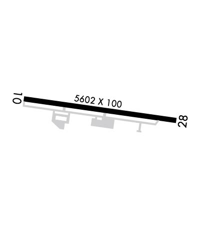
Runway Identifications
Runway Identification: 10/28
Length: 5402 ft
Width: 100 ft
Surface: ASPHALT-GOOD CONDITION
Edge lights: Medium Intensity

Treatment: NONE
Weight: PCN 15 /F/A/X/T

 Runway: 10   Runway: 28
Mag heading: 103°Mag heading: 283°
Rwy Slope: -.03% DownRwy Slope: .03% Up
Approach: Approach:
Pattern: Left TrafficPattern: Left Traffic
Markings: NONPRECISION INSTRUMENTMarkings: NONPRECISION INSTRUMENT
Marking Condition: GOODMarking Condition: GOOD
Arresting Dev: Arresting Dev:
Lat & Long: N3833.3  W08244.8Lat. & Long.: N3833.2  W08243.7
Elev: 546.5 ft. MSLElev: 544.8 ft. MSL
TCH: 37 ft. AGLTCH: 61 ft. AGL
Visual Glide Path: 3.00 degreesVisual Glide Path: 4.00 degrees
Displaced Threshold: NoDisplaced Threshold: No
Touchdown Zone: YESTouchdown Zone: YES
Touchdown Elev.: 546.7 feetTouchdown Elev.: 546.6 feet
Visual Glide Slope: 2-Light PAPI on LEFT side of RunwayVisual Glide Slope: 2-Light PAPI on LEFT side of Runway
RVR Equipment: RVR Equipment:
RVV Equipment: NORVV Equipment: NO
Approach Lights: Approach Lights:
REIL: YESREIL: YES
Centerline Lights: NOCenterline Lights: NO
Touchdown lights: NOTouchdown lights: NO
Runway Category: Runway with a Non-precision Approach having visibility minimums greater than 3/4 mileRunway Category: Runway with a Non-precision Approach having visibility minimums greater than 3/4 mile
Declared Distances: Declared Distances:
Obstructions: TREESObstructions: TREES
Marked: NOT Marked/LightedMarked: NOT Marked/Lighted
Clearance slope: 1:1Clearance slope: 1:1
Obstruction height: 14 feet AGLObstruction height: 18 feet AGL
Dist. from runway: 209 feetDist. from runway: 230 feet
Centerline offset: 177 left of centerlineCenterline offset: 178 feet left of centerline
Comments: Comments:
C:4/P: