KDWH

DAVID WAYNE HOOKS MEMORIAL
HOUSTON
TX
Time Zone: Central
Lat: N 3003.7
Long: W 09533.2
Elev: 152
Var: -05
Longest Runway: 7009
Clr Del: 119.45
Dept. ATIS: 128.37
Arr. ATIS: 128.37
Ground: 121.8
Tower: 118.4/127.4

FBO & Flight Services info for KDWH

FBOs: Update your Fuel Prices

  click here  
OPEN 24 HOURS. Offering Quick Turns, Pilots Lounge, AC Maintenance, PAX Terminal, Hangar Space, Rental Cars, Ramp & Tie-Down Parking, Crew Cars, Courtesy Transportation, Lav Service, Catering, Wifi/Internet Access, Conference Room, Hotel Reservations, Avionics Sales, Restaurant, Volume Fuel.
Ph: 281-376-5436 Fax: 281-251-0030 Freq: 122.95WebsiteE-Mail
                     
Service
Jet
100LL
SAF
MoGas
Fuel Avail: JET A INCLUDES PRIST. 24/7
Full5.396.24    Last Update: 03/18/2024 15:36

Self  5.74    
Misc. Info: Address: 20803 STUEBNER AIRLINE RD   SPRING, TX 77379

ASOSPh: 281-251-7853
-
-
 
If you are an FBO, call 1-203-262-1700 to update your info or email: FltPlan.Advertising@garmin.com
Advertise your FBO on FltPlan.com
FBOs at nearby airports who want your business:
KCXO


  click here  
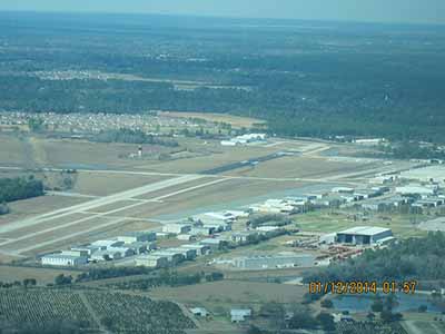
At Galaxy FBO, we strive to meet & exceed expectations, continuously working to improve your experience. Our new facility at the Conroe North Houston Regional Airport features world-class amenities including an arrival/departure canopy large enough to accommodate even the largest corporate jet. Customs & Border Patrol Federal Inspection Station is now in operation, accepting international flights.
Ph: 1-936-494-4252WebsiteE-MailFax: 1-936-494-0176Freq: 130.52

Runway & Approach Info for KDWH
Rwy
Length
Land Dist**
Approach*
  Rwy
Length
Land Dist**
Approach*
17L
3500x35  3500'          
 
  
35R
  3500x35  3292'          
 
17R
7009x100  6002'          
LOC/DME
 110.50 - 168°  
  
35L
  7009x100  7009'          
 
17W
2530x100  2530'          
 
  
35W
  2530x100  2530'          
 
 * only ILS, LOC, LDA, and SDF approaches to a specific runway are shown
** For any Declared Landing Distance Available, please see A/FD or Approach plates
Runway Weight Capability (lbs.) Help
Runway IDSingle WheelDouble WheelDouble Tandem WheelDual Double Wheel
17L/35R12,500N/AN/AN/A
17R/35L30,00085,000N/AN/A
17W/35WN/AN/AN/AN/A
These numbers are Advisory and are not limits.   The Airport Manager should have more accurate Weight Limits
Approach Charts
Approaches    
Current Weather/Notams
Customs Information Send updates to Support@FltPlan.com
Customs Not Available
Database effective 03/21/2024
Airport Diagram of KDWH
Airport Diagram might not be current.

Facility Name: DAVID WAYNE HOOKS MEML
City Name: HOUSTON
County: HARRIS
State abbrev: TX
State Name: TEXAS
   
Ownership: PRIVATELY OWNED
Use: OPEN TO THE PUBLIC
Owner's Name: JAG GILL; NORTHWEST ARPT MANAGEMENT, L.P.
Address: 20803 STEUBNER AIRLINE, NR 0
 SPRING, TX 77379
Owner's Phone: 281-376-5436
  
Manager's Name: ROGER SCHMIDT
Address: 20803 STEUBNER AIRLINE, NR 0
 SPRING, TX 77379
Phone: 281-376-5436
   
FAA Region: SOUTHWEST
FAA Field Office: TEX
Rwys. 35L, 35R, Sea Lane, taxiways, hangars, FBOs


Click here for full scale & interactive Sectional view of KDWH


Sunrise / Sunset times for DAVID WAYNE HOOKS MEML

DateSunriseSunset
03/18/24 Monday7:2819:33
03/19/24 Tuesday7:2619:34
03/20/24 Wednesday7:2519:34
03/21/24 Thursday7:2419:35
03/22/24 Friday7:2319:35
03/23/24 Saturday7:2219:36
03/24/24 Sunday7:2019:37
03/25/24 Monday7:1919:37
03/26/24 Tuesday7:1819:38
03/27/24 Wednesday7:1719:39
03/28/24 Thursday7:1519:39
03/29/24 Friday7:1419:40
03/30/24 Saturday7:1319:40
03/31/24 Sunday7:1219:41

Airport Facilities

Airport Attendance ScheduleCONTINUOUS
Airport Status OPERATIONAL (This Status can change at any time - please check NOTAMS)
Airport Lighting ScheduleWHEN ATCT CLSD ACTVT REIL RWYS 17R & 35L; HIRL RWY 17R/35L - CTAF.
Airport Storage AvailableTie Downs, Hanger
Extra Services AvailableAvionics, Charter, Flight Instruction, Aircraft Rental
Wind IndicatorYES - (lighted)
Control TowerYES
CTAF Frequency118.400
Unicom Frequency122.950
Rotating Beacon ColorWG
Segmented CircleYES
Landing FeeNO

Airport Inspection Data

Airport InspectedSTATE - performed by PRIVATE CONTRACT PERSONNEL
Inspection Date04/10/2023

Airport Services

Type of Fuel AvailableGrade 100LL, JET A (freeze point -40C), JET A-1 (icing inhibitor, freeze point -50C)
Airframe Repair ServiceMAJOR
Power Plant Repair ServiceMAJOR

Geographic Data

LatitudeN3003.7
LongitudeW09533.2 (ESTIMATED)
Arpt Elevation152ft (SURVEYED)
Magnetic Variation05E
17 miles NWof HOUSTON
Traffic Pattern Altitude
Sectional ChartHOUSTON

Aircraft Data

Operations (Reported)YearlyAvg. Daily
General Aviation Transient 69684191
General Aviation Local 78173214
Air Taxi 350310
Commerical 150
Commuter 00
Military 8232
Aircraft based on Field
General Aviation Singles 117
General Aviation Multi 14
Jet Aircraft 5
General Aviation Helicopters 0
Military Aircraft 0
Gliders 0
Ultralights 0

FAA Services

FSS on field NO
FSS tie-in MONTGOMERY COUNTY
FSS Phone 1-800-WX-BRIEF
Who issues Notams DWH
Notam D service at airport YES
ARTCC Name HOUSTON

Federal Status

Airport Certification
Aircraft Rescue & Firefighting IndexNone
Airport of EntryNo
Custom Landing RightsNo
Joint Civil/MilitaryNo
Military Landing rightsYES

Federal Agreements

NATIONAL PLAN OF INTEGRATED AIRPORT SYSTEMS (NPIAS)
INSTALLATION OF NAVIGATIONAL FACILITIES ON PRIVATELY OWNED AIRPORTS UNDER F&E PROGRAM

Remarks

THIS AIRPORT HAS BEEN SURVEYED BY THE NATIONAL GEODETIC SURVEY.
TWYS UNLGTD.
TWYS A & B CLSD EAST OF RWY 17R INDEFLY.
NOISE SENSITIVE AREA SW OF ARPT. ALL MIL ACFT DEPARTING RWY 17R CLIMB RWY HDG TO 650 FT MSL PRIOR TO TURNS OR REJOIN.
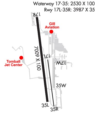
ACFT 25000 LBS & OVR ARE RSTRD TO TWYS C, P, E (BTN TWYS P & G), TWY G (NORTH OF TWY E), RAMPS A AND C AND THE TOMBALL JET CNTR RAMP. ALL OTHER TWYS RSTRD TO ACFT BLW 25000 LBS.
TWYS D & K RSTRD TO ACFT 12500 LBS AND BLW.
INT WHERE TXYS PAPA, ECHO, JULIETTE & KILO MEET IS REFERRED TO AS THE TRIANGLE.
FOR CD WHEN ATCT CLSD, CTC HOUSTON APCH ON CD FREQ OR CALL 281-443-5844. FOR IFR CANCELLATION WHEN ATCT CLSD, CALL 281-443-5888.
BIRDS & DEER ON & INVOF ARPT.
AFT SUNSET LARGE ACFT USE TWY P BTN TWYS E & C.
HEL PRACTICE AREA WEST OF ATCT AT OR BLW 600 FT.
FOUR HEL PRKG SPOTS LCTD EAST OF TWY K.
TWY K RSTRD TO PISTON ACFT ONLY.
Airport Communications & Frequencies:
ATIS Frequencies:   Hours(local) of Operation: CONTINUOUS
128.375
HOOKS Tower Frequencies:   Hours(local) of operation: 0700-2200   
118.4 ;WEST
127.4 ;EAST
354.1
HOOKS Ground Frequencies:
121.8
239.0
Clearance Delivery Frequencies:
119.45
CTAF Frequency:
118.400
Unicom Frequency:
122.950
Remarks
  • GND CTL FREQ 348.6 OTS INDEFLY.
  • HOUSTON Primary Approach Frequencies:  
    119.7
    281.4
    HOUSTON Primary Departure Frequencies:  
    119.7
    281.4
    Runway Identifications
    Runway Identification: 17L/35R
    Length: 3500 ft
    Width: 35 ft
    Surface: ASPHALT-GOOD CONDITION
    Edge lights:

    Treatment: NONE

     Runway: 17L   Runway: 35R
    Mag heading: 168°Mag heading: 348°
    Rwy Slope: -.18% DownRwy Slope: .18% Up
    Approach: Approach:
    Pattern: Left TrafficPattern: Right Traffic
    Markings: BASICMarkings: BASIC
    Marking Condition: GOODMarking Condition: GOOD
    Arresting Dev: Arresting Dev:
    Lat & Long: N3003.8  W09533.1Lat. & Long.: N3003.2  W09533.1
    Elev: 149.9 ft. MSLElev: 143.7 ft. MSL
    TCH: TCH:
    Visual Glide Path: Visual Glide Path:
    Displaced Threshold: NoDisplaced Threshold: 208 feet
    Touchdown Zone: YESTouchdown Zone: YES
    Touchdown Elev.: 149.9 feetTouchdown Elev.: 148.0 feet
    Visual Glide Slope: Visual Glide Slope:
    RVR Equipment: RVR Equipment:
    RVV Equipment: NORVV Equipment: NO
    Approach Lights: Approach Lights:
    REIL: NOREIL: NO
    Centerline Lights: NOCenterline Lights: NO
    Touchdown lights: NOTouchdown lights: NO
    Runway Category: Runway with a Visual ApproachRunway Category: Runway with a Visual Approach
    Declared Distances: Declared Distances:
    Obstructions: ALSO, 45 FT TREE, 274 FT DSTC, 118 FT R, APCH SLOPE 1:1.Obstructions: ANT
    Marked: NOT Marked/LightedMarked: LIGHTED
    Clearance slope: 50:1Clearance slope: APCH RATIO 15:1 AT DSPLCD THR OVR 51 FT TREES, 690 FT DSTC, 195 FT BOTH.
    Obstruction height: Obstruction height: 15 feet AGL
    Dist. from runway: Dist. from runway: 204 feet
    Centerline offset: Centerline offset: 60 feet left of centerline
    Comments: Comments:
    Runway Identification: 17R/35L
    Length: 7009 ft
    Width: 100 ft
    Surface: ASPHALT-GOOD CONDITION
    Edge lights: High Intensity

    Treatment: NONE

     Runway: 17R   Runway: 35L
    Mag heading: 168°Mag heading: 348°
    Rwy Slope: -.07% DownRwy Slope: .07% Up
    Approach: LOC/DMEApproach:
    Pattern: Left TrafficPattern: Left Traffic
    Markings: NONPRECISION INSTRUMENTMarkings: NONPRECISION INSTRUMENT
    Marking Condition: GOODMarking Condition: GOOD
    Arresting Dev: Arresting Dev:
    Lat & Long: N3004.4  W09533.3Lat. & Long.: N3003.3  W09533.1
    Elev: 150.5 ft. MSLElev: 145.3 ft. MSL
    TCH: 52 ft. AGLTCH: 41 ft. AGL
    Visual Glide Path: 3.00 degreesVisual Glide Path: 3.00 degrees
    Displaced Threshold: 1007 feetDisplaced Threshold: No
    Touchdown Zone: YESTouchdown Zone: YES
    Touchdown Elev.: 152.4 feetTouchdown Elev.: 151.7 feet
    Visual Glide Slope: 4-Light PAPI on RIGHT side of RunwayVisual Glide Slope: 4-Light PAPI on LEFT side of Runway
    RVR Equipment: RVR Equipment:
    RVV Equipment: NORVV Equipment: NO
    Approach Lights: Approach Lights:
    REIL: YES; REIL LCTD AT DSPLCD THR.REIL: YES
    Centerline Lights: NOCenterline Lights: NO
    Touchdown lights: NOTouchdown lights: NO
    Runway Category: Runway with a Non-precision Approach having visibility minimums greater than 3/4 mileRunway Category: Runway with a Non-precision Approach having visibility minimums greater than 3/4 mile
    Declared Distances: TORA:7009' TODA:7009' ASDA:7009' LDA:6002'Declared Distances: TORA:6700' TODA:6700' ASDA:6700' LDA:6700'
    Obstructions: ROADObstructions: TREES
    Marked: NOT Marked/LightedMarked: NOT Marked/Lighted
    Clearance slope: APCH RATIO 26:1 AT DSPLCD THR OVR 100 FT TREES 2600 FT DSTC.Clearance slope: 1:1
    Obstruction height: 15 feet AGLObstruction height: 60 feet AGL
    Dist. from runway: 200 feetDist. from runway: 290 feet
    Centerline offset: 125 left of centerlineCenterline offset: 260 feet left of centerline
    Comments: 10 FT DIRT ROAD ON CNTRLN 175 FT FM THR, 8 FT FENCE, 0 FT DSTC, 240 L.Comments:
    Runway Identification: 17W/35W
    Length: 2530 ft
    Width: 100 ft
    Surface: WATER-GOOD CONDITION
    Edge lights:

    Treatment: NONE

     Runway: 17W   Runway: 35W
    Mag heading: N/AMag heading: N/A
    Rwy Slope: .00%Rwy Slope: .00%
    Approach: Approach:
    Pattern: Left TrafficPattern: Right Traffic
    Markings: NONEMarkings: NONE
    Marking Condition: GOOD; BUOYMarking Condition: GOOD; BUOY
    Arresting Dev: Arresting Dev:
    Lat & Long: N3003.9  W09533.1Lat. & Long.: N3003.4  W09533.1
    Elev: 138.0 ft. MSLElev: 138.0 ft. MSL
    TCH: TCH:
    Visual Glide Path: Visual Glide Path:
    Displaced Threshold: NoDisplaced Threshold: No
    Touchdown Zone: YESTouchdown Zone: YES
    Touchdown Elev.: 138.0 feetTouchdown Elev.: 138.0 feet
    Visual Glide Slope: Visual Glide Slope:
    RVR Equipment: RVR Equipment:
    RVV Equipment: NORVV Equipment: NO
    Approach Lights: Approach Lights:
    REIL: NOREIL: NO
    Centerline Lights: NOCenterline Lights: NO
    Touchdown lights: NOTouchdown lights: NO
    Runway Category: Runway with a Visual ApproachRunway Category: Runway with a Visual Approach
    Declared Distances: Declared Distances:
    Obstructions: BERM; ALSO 25 FT HGRS, 185 FT DSTC, 135 FT L, 7:1.Obstructions: BERM
    Marked: NOT Marked/LightedMarked: NOT Marked/Lighted
    Clearance slope: Clearance slope:
    Obstruction height: 10 feet AGLObstruction height: 4 feet AGL
    Dist. from runway: 0 feetDist. from runway: 0 feet
    Centerline offset: Centerline offset:
    Comments: Comments:
    C:98/P: