Click here for more info on on SMS!

KDVL

DEVILS LAKE RGNL
DEVILS LAKE
ND
Time Zone: Central
Lat: N 4807.0
Long: W 09854.6
Elev: 1469
Var: -07
Longest Runway: 6400
AWOS: 125.87
CTAF: 122.8

FBO & Flight Services info for KDVL

FBOs: Update your Fuel Prices
Services include: Jet A, Annuals, Ag aircraft, turbine work, radial engine work, major repairs, major alterations, fabric work, restorations, insurance pick ups & repairs, free estimates, 24hr pilots lounge, curt car available, heated hangar space, catering available and rental cars
Ph: 701-351-5382 Fax: 701-662-4416
-
Website-
                               
Service
Jet
100LL
SAF
MoGas
Fuel Avail: 24/7
Full6.00      Last Update: 04/19/2024 14:14

Self  6.00    
Misc. Info: Address: 300 DAKOTA AERO DR   DEVILS LAKE, ND 58301

FOSS & MEIERPh: 701-662-3221 Fax: 701-662-3229 Freq: 122.8
Service
Jet
100LL
SAF
MoGas
Fuel Avail: PRIST PREMIXED
Full6.256.00    Caution: Fuel prices have not been updated in 35 days.   Last Update: 03/15/2024 13:25  
Self        
 Address: HIGHWAY 19   DEVILS LAKE, ND 58301
AWOSPh: 701-662-7214
-
Freq: 125.87  
If you are an FBO, call 1-203-262-1700 to update your info or email: FltPlan.Advertising@garmin.com
Advertise your FBO on FltPlan.com

Runway & Approach Info for KDVL
Rwy
Length
Land Dist**
Approach*
  Rwy
Length
Land Dist**
Approach*
03
4314x75  4314'          
 
  
21
  4314x75  4314'          
 
13
6400x100  6400'          
 
  
31
  6400x100  6400'          
ILS
 108.70 - 311°  
 * only ILS, LOC, LDA, and SDF approaches to a specific runway are shown
** For any Declared Landing Distance Available, please see A/FD or Approach plates
Runway Weight Capability (lbs.) Help
Runway IDSingle WheelDouble WheelDouble Tandem WheelDual Double Wheel
03/2130,000N/AN/AN/A
13/3175,000130,000190,000N/A
These numbers are Advisory and are not limits.   The Airport Manager should have more accurate Weight Limits
Approach Charts
Approaches    
Current Weather/Notams
Customs Information Send updates to Support@FltPlan.com
Customs Not Available
Database effective 04/18/2024
Airport Diagram of KDVL
Airport Diagram might not be current.

Facility Name: DEVILS LAKE RGNL
City Name: DEVILS LAKE
County: RAMSEY
State abbrev: ND
State Name: NORTH DAKOTA
   
Ownership: PUBLICLY OWNED
Use: OPEN TO THE PUBLIC
Owner's Name: DEVILS LAKE AIRPORT AUTHORITY
Address: 106 NATIONAL GUARD ST NW
 DEVILS LAKE, ND 58301-8993
Owner's Phone: 701-662-5833
  
Manager's Name: SCOTT CRUSE
Address: 106 NATIONAL GUARD ST NW
 DEVILS LAKE, ND 58301-8993
Phone: 701-662-5833
   
FAA Region: GREAT LAKES
FAA Field Office: DMA


Sunrise / Sunset times for DEVILS LAKE RGNL

DateSunriseSunset
04/18/24 Thursday6:3920:32
04/19/24 Friday6:3720:33
04/20/24 Saturday6:3520:35
04/21/24 Sunday6:3320:36
04/22/24 Monday6:3120:37
04/23/24 Tuesday6:3020:39
04/24/24 Wednesday6:2820:40
04/25/24 Thursday6:2620:42
04/26/24 Friday6:2420:43
04/27/24 Saturday6:2320:45
04/28/24 Sunday6:2120:46
04/29/24 Monday6:1920:47
04/30/24 Tuesday6:1720:49
05/01/24 Wednesday6:1620:50

Airport Facilities

Airport Attendance Schedule7 Days A Week 0700-1800; FOR ATNDT AFT HRS CALL 701-520-0229.
Airport Status OPERATIONAL (This Status can change at any time - please check NOTAMS)
Airport Lighting ScheduleACTVT OR INCR INTST MALSR RWY 31; REIL RWY 03, 13, & 21; PAPI RWY 13/31; HIRL RWY 13/31, MIRL RWY 03/21 - CTAF.
Airport Storage AvailableTie Downs, Hanger
Extra Services AvailableAir Freight, Crop Dusting, Air Ambulance, Charter, Flight Instruction, Aircraft Rental, Aircraft Sales, Annual Surveying
Wind IndicatorYES - (lighted)
Control TowerNO
CTAF Frequency122.800
Unicom Frequency122.800
Rotating Beacon ColorWG
Segmented CircleNO
Landing FeeNO

Airport Inspection Data

Airport InspectedSTATE - performed by FAA AIRPORTS FIELD PERSONNEL
Inspection Date09/28/2022

Airport Services

Type of Fuel AvailableGrade 100LL, JET A (freeze point -40C); -A FUEL AVBL IREG HRS CALL 701-520-0229; SELF SVC AVGAS AVBL H24.
Airframe Repair ServiceMAJOR
Power Plant Repair ServiceMAJOR

Geographic Data

LatitudeN4807.0
LongitudeW09854.6 (ESTIMATED)
Arpt Elevation1469ft (SURVEYED)
Magnetic Variation07E
2 miles Wof DEVILS LAKE
Traffic Pattern Altitude
Sectional ChartTWIN CITIES

Aircraft Data

Operations (Reported)YearlyAvg. Daily
General Aviation Transient 470013
General Aviation Local 1500041
Air Taxi 24507
Commerical 12303
Commuter 00
Military 4001
Aircraft based on Field
General Aviation Singles 24
General Aviation Multi 3
Jet Aircraft 1
General Aviation Helicopters 0
Military Aircraft 0
Gliders 0
Ultralights 0

FAA Services

FSS on field NO
FSS tie-in GRAND FORKS
FSS Phone 1-800-WX-BRIEF
Who issues Notams DVL
Notam D service at airport YES
ARTCC Name MINNEAPOLIS

Federal Status

Airport CertificationAIRPORT RECEIVING SCHEDULED AIR CARRIER SERVICE FROM CARRIERS CERTIFICATED BY THE CIVIL AERONAUTICS BOARD; 48 HRS PPR FOR UNSKED ACR OPS W/ MORE THAN 30 PSGRS CALL AMGR 701-662-5833.
Aircraft Rescue & Firefighting IndexAIRPORT HAS A CERTIFICATE UNDER CFR PART 139
Airport of EntryNo
Custom Landing RightsNo
Joint Civil/MilitaryNo
Military Landing rightsYES

Federal Agreements

NATIONAL PLAN OF INTEGRATED AIRPORT SYSTEMS (NPIAS)
GRANT AGREEMENTS UNDER FAAP/ADAP/AIP
ASSURANCES PURSUANT TO TITLE VI, CIVIL RIGHTS ACT OF 1964
AGREEMENT UNDER DLAND OR DCLA HAS EXPIRED.

Remarks

NUMEROUS WATERFOWL & OTHER BIRDS; DEER & JACK RABBITS ON & INVOF ARPT.
FOR CD IF UNA TO CTC ON FSS FREQ, CTC MINNEAPOLIS ARTCC AT 651-463-5588.
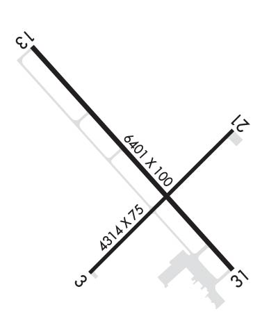
RWY 03/2 1 NOT AVBL FOR ACR WITH MORE THAN 9 PSGR SEATS.
Airport Communications & Frequencies:
CTAF Frequency:
122.800
Unicom Frequency:
122.800
Remarks
  • COMMUNICATIONS PRVDD BY GRAND FORKS RADIO ON FREQ 122.3 (DEVILS LAKE RCO).
  • APCH/DEP SVC PRVDD BY MINNEAPOLIS ARTCC (ZMP) ON FREQ 124.2/270.3 (WOODWORTH RCAG).
  • Runway Identifications
    Runway Identification: 03/21
    Length: 4314 ft
    Width: 75 ft
    Surface: ASPHALT-GOOD CONDITION
    Edge lights: Medium Intensity

    Treatment: NONE
    Weight: PCN 26 /F/D/W/T

     Runway: 03   Runway: 21
    Mag heading: 38°Mag heading: 218°
    Rwy Slope: -.21% DownRwy Slope: .21% Up
    Approach: Approach:
    Pattern: Left TrafficPattern: Left Traffic
    Markings: NONPRECISION INSTRUMENTMarkings: NONPRECISION INSTRUMENT
    Marking Condition: GOODMarking Condition: GOOD
    Arresting Dev: Arresting Dev:
    Lat & Long: N4806.7  W09854.9Lat. & Long.: N4807.2  W09854.1
    Elev: 1449.9 ft. MSLElev: 1441.0 ft. MSL
    TCH: 25 ft. AGLTCH: 25 ft. AGL
    Visual Glide Path: 3.00 degreesVisual Glide Path: 3.00 degrees
    Displaced Threshold: NoDisplaced Threshold: No
    Touchdown Zone: YESTouchdown Zone: YES
    Touchdown Elev.: 1449.9 feetTouchdown Elev.: 1449.2 feet
    Visual Glide Slope: 2-Light PAPI on LEFT side of RunwayVisual Glide Slope: 2-Light PAPI on LEFT side of Runway
    RVR Equipment: RVR Equipment:
    RVV Equipment: NORVV Equipment: NO
    Approach Lights: Approach Lights:
    REIL: YESREIL: YES
    Centerline Lights: NOCenterline Lights: NO
    Touchdown lights: NOTouchdown lights: NO
    Runway Category: Runway with a Non-precision ApproachRunway Category: Runway with a Non-precision Approach
    Declared Distances: TORA:4314' TODA:4314' ASDA:4314' LDA:4314'Declared Distances: TORA:4314' TODA:4314' ASDA:4314' LDA:4314'
    Obstructions: ROADObstructions: TREE
    Marked: NOT Marked/LightedMarked: NOT Marked/Lighted
    Clearance slope: 26:1Clearance slope: 40:1
    Obstruction height: 35 feet AGLObstruction height: 38 feet AGL
    Dist. from runway: 1119 feetDist. from runway: 1523 feet
    Centerline offset: 384 left of centerlineCenterline offset: 131 feet right of centerline
    Comments: Comments:
    Runway Identification: 13/31
    Length: 6400 ft
    Width: 100 ft
    Surface: ASPHALT-GOOD CONDITION
    Edge lights: High Intensity

    Treatment: GROOVED
    Weight: PCN 27 /F/D/W/T

     Runway: 13   Runway: 31
    Mag heading: 131°Mag heading: 311°
    Rwy Slope: -.41% DownRwy Slope: .41% Up
    Approach: Approach: ILS
    Pattern: Left TrafficPattern: Left Traffic
    Markings: NONPRECISION INSTRUMENTMarkings: PRECISION INSTRUMENT
    Marking Condition: GOODMarking Condition: GOOD
    Arresting Dev: Arresting Dev:
    Lat & Long: N4807.4  W09855.2Lat. & Long.: N4806.7  W09854.1
    Elev: 1469.4 ft. MSLElev: 1443.3 ft. MSL
    TCH: 45 ft. AGLTCH: 44 ft. AGL
    Visual Glide Path: 3.00 degreesVisual Glide Path: 3.00 degrees
    Displaced Threshold: NoDisplaced Threshold: No
    Touchdown Zone: YESTouchdown Zone: YES
    Touchdown Elev.: 1469.4 feetTouchdown Elev.: 1450.1 feet
    Visual Glide Slope: 4-Light PAPI on LEFT side of RunwayVisual Glide Slope: 4-Light PAPI on LEFT side of Runway
    RVR Equipment: RVR Equipment:
    RVV Equipment: NORVV Equipment: NO
    Approach Lights: Approach Lights: MALSR - 1,400 foot medium intensity approach lighting system with runway alignment indicator lights
    REIL: YESREIL: NO
    Centerline Lights: NOCenterline Lights: NO
    Touchdown lights: NOTouchdown lights: NO
    Runway Category: DRunway Category: Precision Instrument Runway
    Declared Distances: TORA:6401' TODA:6401' ASDA:6401' LDA:6401'Declared Distances: TORA:6401' TODA:6401' ASDA:6401' LDA:6401'
    Obstructions: Obstructions: BLDG
    Marked: Marked: NOT Marked/Lighted
    Clearance slope: 34:1Clearance slope: 41:1
    Obstruction height: Obstruction height: 29 feet AGL
    Dist. from runway: Dist. from runway: 1400 feet
    Centerline offset: Centerline offset: 650 feet left of centerline
    Comments: Comments:
    C:5/P: