Current Weather/Notams (Metars, TAFs, Notams, NWS Forecast, PIREPS, and nearby weather)
Customs Information Send updates to Support@FltPlan.com
Customs Not Available
Database effective 05/16/2024
Airport Diagram might not be current.
|
| Facility Name: | STUART POWELL FLD |
| City Name: | DANVILLE |
| County: | BOYLE |
| State abbrev: | KY |
| State Name: | KENTUCKY |
| | |
| Ownership: | PUBLICLY OWNED |
| Use: | OPEN TO THE PUBLIC |
| Owner's Name: | CITY OF DANVILLE & BOYLE COUNTY |
| Address: | CITY HALL |
| | DANVILLE, KY 40422-9424 |
| Owner's Phone: | 859-236-8917; ROB CALDWELL 859-319-9414. |
| | |
| Manager's Name: | CHRISTIAN BARKER; NICK BARKER 859-853-1701 |
| Address: | 420 AIRPORT ROAD |
| | DANVILLE, KY 40422-9424 |
| Phone: | 859-854-5994 |
| | |
| FAA Region: | SOUTHERN |
| FAA Field Office: | MEM |
Runway Identifications
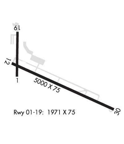
Runway Identification: 01/19Length: 1971 ft
Width: 75 ft
Surface: ASPHALT
Edge lights: Treatment: RUBBERIZED FRICTION SEAL COAT
| | Runway: 01 | | Runway: 19 |
| Mag heading: | 11° | Mag heading: | 191° |
| Rwy Slope: | .39% Up | Rwy Slope: | -.39% Down |
| Approach: | | Approach: | |
| Pattern: | Left Traffic | Pattern: | Left Traffic |
| Markings: | BASIC | Markings: | BASIC |
| Marking Condition: | GOOD | Marking Condition: | GOOD |
| Arresting Dev: | | Arresting Dev: | |
| Lat & Long: | N3734.7 W08446.5 | Lat. & Long.: | N3735.0 W08446.4 |
| Elev: | 1013.6 ft. MSL | Elev: | 1021.3 ft. MSL |
| TCH: | | TCH: | |
| Visual Glide Path: | | Visual Glide Path: | |
| Displaced Threshold: | No | Displaced Threshold: | 162 feet |
| Touchdown Zone: | YES | Touchdown Zone: | YES |
| Touchdown Elev.: | 1022.0 feet | Touchdown Elev.: | 1022.0 feet |
| Visual Glide Slope: | | Visual Glide Slope: | |
| RVR Equipment: | | RVR Equipment: | |
| RVV Equipment: | NO | RVV Equipment: | NO |
| Approach Lights: | | Approach Lights: | |
| REIL: | NO | REIL: | NO |
| Centerline Lights: | NO | Centerline Lights: | NO |
| Touchdown lights: | NO | Touchdown lights: | NO |
| Runway Category: | Runway with a Visual Approach | Runway Category: | Runway with a Visual Approach |
| Declared Distances: | | Declared Distances: | |
| Obstructions: | TREES; WIND CONE ON HNGR. | Obstructions: | HANGAR |
| Marked: | NOT Marked/Lighted | Marked: | NOT Marked/Lighted |
| Clearance slope: | 7:1 | Clearance slope: | 8:1; 21:1 TO DTHR. |
| Obstruction height: | 48 feet AGL | Obstruction height: | 27 feet AGL |
| Dist. from runway: | 542 feet | Dist. from runway: | 429 feet |
| Centerline offset: | 87 left of centerline | Centerline offset: | 107 feet right of centerline |
| Comments: | 6 FT FENCE 196 FT FM THR. | Comments: | |
Runway Identification: 13/31Length: 5000 ft
Width: 75 ft
Surface: ASPHALT-FAIR CONDITION
Edge lights: Medium IntensityTreatment: NONE
Weight: PCN 23 /F/D/X/T
| | Runway: 13 | | Runway: 31 |
| Mag heading: | 125° | Mag heading: | 305° |
| Rwy Slope: | .02% Up | Rwy Slope: | -.02% Down |
| Approach: | | Approach: | LOC/DME |
| Pattern: | Left Traffic | Pattern: | Left Traffic |
| Markings: | NONPRECISION INSTRUMENT | Markings: | NONPRECISION INSTRUMENT |
| Marking Condition: | GOOD | Marking Condition: | GOOD |
| Arresting Dev: | | Arresting Dev: | |
| Lat & Long: | N3734.8 W08446.5 | Lat. & Long.: | N3734.4 W08445.6 |
| Elev: | 1014.5 ft. MSL | Elev: | 1015.5 ft. MSL |
| TCH: | 34 ft. AGL | TCH: | 30 ft. AGL |
| Visual Glide Path: | 3.00 degrees | Visual Glide Path: | 3.00 degrees |
| Displaced Threshold: | No | Displaced Threshold: | No |
| Touchdown Zone: | YES | Touchdown Zone: | YES |
| Touchdown Elev.: | 1016.5 feet | Touchdown Elev.: | 1016.1 feet |
| Visual Glide Slope: | 4-Light PAPI on LEFT side of Runway | Visual Glide Slope: | 4-Light PAPI on LEFT side of Runway |
| RVR Equipment: | | RVR Equipment: | |
| RVV Equipment: | NO | RVV Equipment: | NO |
| Approach Lights: | | Approach Lights: | |
| REIL: | NO | REIL: | YES |
| Centerline Lights: | NO | Centerline Lights: | NO |
| Touchdown lights: | NO | Touchdown lights: | NO |
| Runway Category: | Runway with a Non-precision Approach having visibility minimums greater than 3/4 mile | Runway Category: | Runway with a Non-precision Approach having visibility minimums greater than 3/4 mile |
| Declared Distances: | | Declared Distances: | |
| Obstructions: | TREES | Obstructions: | |
| Marked: | NOT Marked/Lighted | Marked: | |
| Clearance slope: | 5:1 | Clearance slope: | 34:1 |
| Obstruction height: | 45 feet AGL | Obstruction height: | |
| Dist. from runway: | 467 feet | Dist. from runway: | |
| Centerline offset: | 250 right of centerline | Centerline offset: | |
| Comments: | | Comments: | |

