Click here for more info on on SMS!

KDUG

BISBEE DOUGLAS INTL
DOUGLAS BISBEE
AZ
Time Zone: Pacific
Lat: N 3128.1
Long: W 10936.2
Elev: 4150
Var: -12
Longest Runway: 6430
AWOS: 119.27
CTAF: 123.0

FBO & Flight Services info for KDUG

FBOs: Update your Fuel Prices

  click here  
Providing high quality fuel and services to you and your customers, from Phillips 66 Aviation.
Ph: 520-364-2771 Fax: 520-364-8234 Freq: 123.0WebsiteE-Mail
Service
Jet
100LL
SAF
MoGas
Fuel Avail: Self Serve
Full        Caution: Fuel prices have not been updated in 34 days.
Last Update: 03/15/2024 12:45

Self6.456.85    
Misc. Info: Self Sevice 24/7 Jet-A 100LL Hose 100' on both fuel stationsAddress: 6940 NORTH AIR TERMINAL BLVD   DOUGLAS AZ 85607

ASOSPh: 520-364-7208
-
Freq: 119.27  
If you are an FBO, call 1-203-262-1700 to update your info or email: FltPlan.Advertising@garmin.com
Advertise your FBO on FltPlan.com

Runway & Approach Info for KDUG
Rwy
Length
Land Dist**
Approach*
  Rwy
Length
Land Dist**
Approach*
08
4966x60  4966'          
 
  
26
  4966x60  4966'          
 
17
6430x100  6430'          
 
  
35
  6430x100  6430'          
 
 * only ILS, LOC, LDA, and SDF approaches to a specific runway are shown
** For any Declared Landing Distance Available, please see A/FD or Approach plates
Runway Weight Capability (lbs.) Help
Runway IDSingle WheelDouble WheelDouble Tandem WheelDual Double Wheel
08/2612,500N/AN/AN/A
17/3530,000160,000250,000N/A
These numbers are Advisory and are not limits.   The Airport Manager should have more accurate Weight Limits
Approach Charts
Approaches    
Current Weather/Notams
Customs Information Send updates to Support@FltPlan.com
Phone 520-364-8486
Fax 520-364-2313

Comments Mon-Fri 0900-1700 1 hr advanced notice required upon entering US airspace *Maximum passengers per flight *Call prior to 1700 on preceding weekday *Call prior to 1700 on preceding Friday for weekend service. Prior approval required
Database effective 04/18/2024
Airport Diagram of KDUG
Airport Diagram might not be current.

Facility Name: BISBEE DOUGLAS INTL
City Name: DOUGLAS BISBEE
County: COCHISE
State abbrev: AZ
State Name: ARIZONA
   
Ownership: PUBLICLY OWNED
Use: OPEN TO THE PUBLIC
Owner's Name: COCHISE COUNTY
Address: 1415 WEST MELODY LANE BLDG F
 BISBEE, AZ 85603
Owner's Phone: (520) 432-9268
  
Manager's Name: DANIEL COXWORTH
Address: 1415 W. MELODY LANE , BUILDING F, BUILDING E
 BISBEE, AZ 85603
Phone: (520) 432-9268; EMERGENCY NUMBER 520-432-9268.
   
FAA Region: WESTERN-PACIFIC
FAA Field Office: PHX
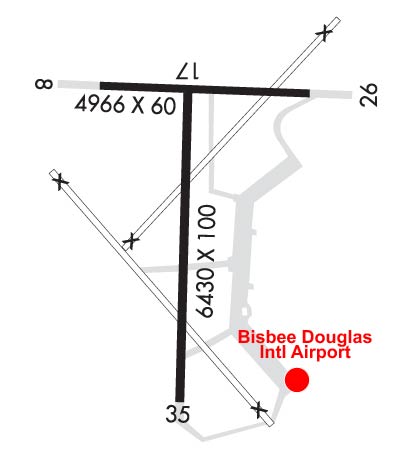

Sunrise / Sunset times for BISBEE DOUGLAS INTL

DateSunriseSunset
04/17/24 Wednesday5:4718:49
04/18/24 Thursday5:4618:50
04/19/24 Friday5:4518:50
04/20/24 Saturday5:4418:51
04/21/24 Sunday5:4318:52
04/22/24 Monday5:4118:52
04/23/24 Tuesday5:4018:53
04/24/24 Wednesday5:3918:54
04/25/24 Thursday5:3818:55
04/26/24 Friday5:3718:55
04/27/24 Saturday5:3618:56
04/28/24 Sunday5:3518:57
04/29/24 Monday5:3418:57
04/30/24 Tuesday5:3318:58

Airport Facilities

Airport Attendance ScheduleMON-FRI 0700-1500
Airport Status OPERATIONAL (This Status can change at any time - please check NOTAMS)
Airport Lighting ScheduleACTVT VASI RWY 17; MIRL RWY 17/35 - CTAF.
Airport Storage AvailableTie Downs
Extra Services AvailableNONE
Wind IndicatorYES - (lighted)
Control TowerNO
CTAF Frequency123.000
Unicom Frequency123.000
Rotating Beacon ColorWG
Segmented CircleYES
Landing FeeNO

Airport Inspection Data

Airport InspectedSTATE - performed by PRIVATE CONTRACT PERSONNEL
Inspection Date04/10/2023

Airport Services

Type of Fuel AvailableGrade 100LL, JET A-1 (icing inhibitor, freeze point -50C); -10SELF-SERVE FUEL, PHONE 520-432-9268.
Airframe Repair ServiceNONE
Power Plant Repair ServiceNONE

Geographic Data

LatitudeN3128.1
LongitudeW10936.2 (ESTIMATED)
Arpt Elevation4150ft (SURVEYED)
Magnetic Variation12E
8 miles NWof DOUGLAS BISBEE
Traffic Pattern Altitude
Sectional ChartPHOENIX

Aircraft Data

Operations (Reported)YearlyAvg. Daily
General Aviation Transient 1500041
General Aviation Local 400011
Air Taxi 5001
Commerical 00
Commuter 00
Military 1000027
Aircraft based on Field
General Aviation Singles 2
General Aviation Multi 0
Jet Aircraft 0
General Aviation Helicopters 0
Military Aircraft 0
Gliders 0
Ultralights 0

FAA Services

FSS on field NO
FSS tie-in PRESCOTT
FSS Phone 1-800-WX-BRIEF
Who issues Notams DUG
Notam D service at airport YES
ARTCC Name ALBUQUERQUE

Federal Status

Airport Certification
Aircraft Rescue & Firefighting IndexNone
Airport of EntryYES
Custom Landing RightsNo
Joint Civil/MilitaryNo
Military Landing rightsYES

Federal Agreements

NATIONAL PLAN OF INTEGRATED AIRPORT SYSTEMS (NPIAS)
GRANT AGREEMENTS UNDER FAAP/ADAP/AIP
SURPLUS PROPERTY AGREEMENT UNDER PUBLIC LAW 289
ASSURANCES PURSUANT TO TITLE VI, CIVIL RIGHTS ACT OF 1964
AGREEMENT UNDER DLAND OR DCLA HAS EXPIRED.

Remarks

WILDLIFE ON OR INVOF ARPT.
FOR CD IF UNA TO CTC ON FSS FREQ, CTC ALBUQUERQUE ARTCC AT 505-856-4561.
RWY 08/2 6 RY 08/26 VFR OPNS ONLY; DAYLIGHT USE ONLY.
RWY 17/3 5 RFSC 100 FT WIDE.
Airport Communications & Frequencies:
CTAF Frequency:
123.000
Unicom Frequency:
123.000
Remarks
  • COMMUNICATIONS PRVDD BY PRESCOTT RADIO ON FREQ 122.6 (DOUGLAS RCO).
  • APCH/DEP SVC PRVDD BY ALBUQUERQUE ARTCC (ABQ) ON 134.45/327.15 (SILVER CITY RCAG & 133.0/281.5 TUCSON RCAG).
  • Runway Identifications
    Runway Identification: 08/26
    Length: 4966 ft
    Width: 60 ft
    Surface: ASPHALT-FAIR CONDITION
    Edge lights:

    Treatment: NONE

     Runway: 08   Runway: 26
    Mag heading: 78°Mag heading: 258°
    Rwy Slope: .69% UpRwy Slope: -.69% Down
    Approach: Approach:
    Pattern: Left TrafficPattern: Left Traffic
    Markings: BASICMarkings: BASIC
    Marking Condition: FAIRMarking Condition: FAIR
    Arresting Dev: Arresting Dev:
    Lat & Long: N3128.4  W10936.6Lat. & Long.: N3128.4  W10935.7
    Elev: 4115.6 ft. MSLElev: 4150.0 ft. MSL
    TCH: TCH:
    Visual Glide Path: Visual Glide Path:
    Displaced Threshold: NoDisplaced Threshold: No
    Touchdown Zone: YESTouchdown Zone: YES
    Touchdown Elev.: 4133.5 feetTouchdown Elev.: 4150.2 feet
    Visual Glide Slope: Visual Glide Slope:
    RVR Equipment: RVR Equipment:
    RVV Equipment: NORVV Equipment: NO
    Approach Lights: Approach Lights:
    REIL: NOREIL: NO
    Centerline Lights: NOCenterline Lights: NO
    Touchdown lights: NOTouchdown lights: NO
    Runway Category: Runway with a Visual ApproachRunway Category: Runway with a Visual Approach
    Declared Distances: Declared Distances:
    Obstructions: BRUSHObstructions: BRUSH
    Marked: NOT Marked/LightedMarked: NOT Marked/Lighted
    Clearance slope: 16:1; CONTROLLING OBSTRUCTION EXCEEDS A 45 DEGREE SLOPEClearance slope:
    Obstruction height: 4 feet AGLObstruction height: 5 feet AGL
    Dist. from runway: 264 feetDist. from runway: 201 feet
    Centerline offset: 44 right of centerlineCenterline offset: 70 feet left of centerline
    Comments: RWY 08, 1-8 FT SCATTERED BRUSH, 40-200 FT FM THR, 45-125 FT BOTH SIDES OF CNTRLN.Comments: RWY 26, 4-6 FT BRUSH 20-200 FT FM THR, 75 FT BOTH BOTH SIDES OF CNTRLN.
    Runway Identification: 17/35
    Length: 6430 ft
    Width: 100 ft
    Surface: ASPHALT-GOOD CONDITION
    Edge lights: Medium Intensity

    Treatment: RUBBERIZED FRICTION SEAL COAT

     Runway: 17   Runway: 35
    Mag heading: 168°Mag heading: 348°
    Rwy Slope: -.55% DownRwy Slope: .55% Up
    Approach: Approach:
    Pattern: Left TrafficPattern: Left Traffic
    Markings: NONPRECISION INSTRUMENTMarkings: NONPRECISION INSTRUMENT
    Marking Condition: GOODMarking Condition: GOOD
    Arresting Dev: Arresting Dev:
    Lat & Long: N3128.4  W10936.3Lat. & Long.: N3127.4  W10936.3
    Elev: 4124.5 ft. MSLElev: 4088.9 ft. MSL
    TCH: 53 ft. AGLTCH:
    Visual Glide Path: 3.25 degreesVisual Glide Path:
    Displaced Threshold: NoDisplaced Threshold: No
    Touchdown Zone: YESTouchdown Zone: YES
    Touchdown Elev.: 4125.0 feetTouchdown Elev.: 4107.6 feet
    Visual Glide Slope: 2-Box VASI on LEFT side of RunwayVisual Glide Slope:
    RVR Equipment: RVR Equipment:
    RVV Equipment: NORVV Equipment: NO
    Approach Lights: Approach Lights:
    REIL: NOREIL: NO
    Centerline Lights: NOCenterline Lights: NO
    Touchdown lights: NOTouchdown lights: NO
    Runway Category: Runway with a Non-precision Approach having visibility minimums greater than 3/4 mileRunway Category: Runway with a Visual Approach
    Declared Distances: Declared Distances:
    Comments: AIRPLANE TAIL HEIGHT OF 20 FT ON RWY 08/26, AT 55 FT TO CNTRLN APCH SLOPE 04:1 AT THR. 2-3 FT BRUSH & WEEDS 125 FT FM THR, 125-250 FT RIGHT OF CNTRLN.Comments: RWY 35, 1-2 FT GRASS, 0-200 FT FM THR, 100-250 FT LEFT OF CNTRLN.
    C:1/P: