
| ||||||||||||||||||||||||||||||||||||||||||||
| ||||||||||||||||||||||||||||||||||||||||||||
| ||||||||||||||||||||||||||||||||||||||||||||
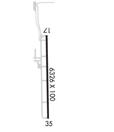
| Rwy | Rwy | |||||||
| 6650x100 | 6650' | 6650x100 | 6325' | 111.50 - 352° | ||||
| Runway ID | Single Wheel | Double Wheel | Double Tandem Wheel | Dual Double Wheel |
| 17/35 | 44,000 | 56,000 | N/A | 101,000 |
| These numbers are Advisory and are not limits. The Airport Manager should have more accurate Weight Limits | ||||
 Airport Diagram might not be current. | |
| Facility Name: | HALLIBURTON FLD |
| City Name: | DUNCAN |
| County: | STEPHENS |
| State abbrev: | OK |
| State Name: | OKLAHOMA |
| Ownership: | PUBLICLY OWNED |
| Use: | OPEN TO THE PUBLIC |
| Owner's Name: | CITY OF DUNCAN |
| Address: | 1600 S. HWY 81, 720 W. WILLOW |
| DUNCAN, OK 73533 | |
| Owner's Phone: | 580-252-0250 |
| Manager's Name: | BUDDY HOKIT; PUB WORKS DIR. |
| Address: | 2700 S 13TH ST, 1220 M. L. KING |
| DUNCAN, OK 73533 | |
| Phone: | 580-470-2095; PHONE NR FOR PUB WORKS. ARPT TRML BLDG CTC 580-252-9896. |
| FAA Region: | SOUTHWEST |
| FAA Field Office: | AOK |
| Date | Sunrise | Sunset |
|---|---|---|
| 04/25/24 Thursday | 6:48 | 20:12 |
| 04/26/24 Friday | 6:46 | 20:13 |
| 04/27/24 Saturday | 6:45 | 20:14 |
| 04/28/24 Sunday | 6:44 | 20:15 |
| 04/29/24 Monday | 6:43 | 20:15 |
| 04/30/24 Tuesday | 6:42 | 20:16 |
| 05/01/24 Wednesday | 6:41 | 20:17 |
| 05/02/24 Thursday | 6:40 | 20:18 |
| 05/03/24 Friday | 6:39 | 20:19 |
| 05/04/24 Saturday | 6:38 | 20:19 |
| 05/05/24 Sunday | 6:37 | 20:20 |
| 05/06/24 Monday | 6:36 | 20:21 |
| 05/07/24 Tuesday | 6:35 | 20:22 |
| 05/08/24 Wednesday | 6:34 | 20:23 |
| Airport Attendance Schedule | 7 Days A Week 0800-1700; SECURITY PATROLS ARPT AFT HRS. |
| Airport Status | OPERATIONAL (This Status can change at any time - please check NOTAMS) |
| Airport Lighting Schedule | ACTVT ODALS RWY 17 MED & HIGH INTST ONLY; REIL RWY 35; PAPI RWY 17; VASI RWY 35; MIRL RWY 17/35 - CTAF. |
| Airport Storage Available | Tie Downs, Hanger |
| Extra Services Available | Air Ambulance, Flight Instruction, Aircraft Rental |
| Wind Indicator | YES - (lighted) |
| Control Tower | NO |
| CTAF Frequency | 122.800 |
| Unicom Frequency | 122.800 |
| Rotating Beacon Color | WG |
| Segmented Circle | YES |
| Landing Fee | NO |
| Airport Inspected | STATE - performed by STATE AERONAUTICAL PERSONNEL |
| Inspection Date | 08/24/2023 |
| Type of Fuel Available | Grade 100LL, JET A; -10FOR FUEL AFT HRS CALL 580-656-2020 OR 580-583-7196. |
| Airframe Repair Service | MAJOR |
| Power Plant Repair Service | MAJOR |
| Latitude | N3428.3 |
| Longitude | W09757.6 (ESTIMATED) |
| Arpt Elevation | 1114ft (ESTIMATED) |
| Magnetic Variation | 04E |
| 2 miles S | of DUNCAN |
| Traffic Pattern Altitude | |
| Sectional Chart | DALLAS-FT WORTH |
| Operations (Reported) | Yearly | Avg. Daily |
|---|---|---|
| General Aviation Transient | 2500 | 7 |
| General Aviation Local | 6000 | 16 |
| Air Taxi | 250 | 1 |
| Commerical | 0 | 0 |
| Commuter | 0 | 0 |
| Military | 0 | 0 |
| Aircraft based on Field | |
|---|---|
| General Aviation Singles | 27 |
| General Aviation Multi | 7 |
| Jet Aircraft | 3 |
| General Aviation Helicopters | 2 |
| Military Aircraft | 0 |
| Gliders | 0 |
| Ultralights | 0 |
| FSS on field | NO |
| FSS tie-in | MC ALESTER |
| FSS Phone | 1-800-WX-BRIEF |
| Who issues Notams | DUC |
| Notam D service at airport | YES |
| ARTCC Name | FORT WORTH |
| Airport Certification | |
| Aircraft Rescue & Firefighting Index | None |
| Airport of Entry | No |
| Custom Landing Rights | No |
| Joint Civil/Military | No |
| Military Landing rights | YES |
| NATIONAL PLAN OF INTEGRATED AIRPORT SYSTEMS (NPIAS) |
| GRANT AGREEMENTS UNDER FAAP/ADAP/AIP |
| ASSURANCES PURSUANT TO TITLE VI, CIVIL RIGHTS ACT OF 1964 |
| FOR CD CTC FORT WORTH ARTCC AT 817-858-7584. |
Airport Communications & Frequencies:
| ||||||||||||||||
| Runway: 17 | Runway: 35 | ||
| Mag heading: | 175° | Mag heading: | 355° |
| Rwy Slope: | -.43% Down | Rwy Slope: | .43% Up |
| Approach: | Approach: | LOCALIZER | |
| Pattern: | Left Traffic | Pattern: | Left Traffic |
| Markings: | NONPRECISION INSTRUMENT | Markings: | NONPRECISION INSTRUMENT |
| Marking Condition: | GOOD | Marking Condition: | GOOD |
| Arresting Dev: | Arresting Dev: | ||
| Lat & Long: | N3428.8 W09757.6 | Lat. & Long.: | N3427.7 W09757.6 |
| Elev: | 1114.3 ft. MSL | Elev: | 1086.0 ft. MSL |
| TCH: | 53 ft. AGL | TCH: | 42 ft. AGL |
| Visual Glide Path: | 3.00 degrees | Visual Glide Path: | 3.00 degrees |
| Displaced Threshold: | No | Displaced Threshold: | 325 feet |
| Touchdown Zone: | YES | Touchdown Zone: | YES |
| Touchdown Elev.: | 1114.3 feet | Touchdown Elev.: | 1093.9 feet |
| Visual Glide Slope: | 4-Light PAPI on RIGHT side of Runway | Visual Glide Slope: | 4-BOX VASI ON LEFT SIDE OF RUNWAY |
| RVR Equipment: | RVR Equipment: | ||
| RVV Equipment: | NO | RVV Equipment: | NO |
| Approach Lights: | ODALS - omnidirectional approach lighting system | Approach Lights: | |
| REIL: | NO | REIL: | YES |
| Centerline Lights: | NO | Centerline Lights: | NO |
| Touchdown lights: | NO | Touchdown lights: | NO |
| Runway Category: | Runway with a Non-precision Approach having visibility minimums greater than 3/4 mile | Runway Category: | Runway with a Non-precision Approach having visibility minimums greater than 3/4 mile |
| Declared Distances: | TORA:6325' TODA:6325' ASDA:6325' LDA:6325' | Declared Distances: | TORA:6650' TODA:6650' ASDA:6650' LDA:6325' |
