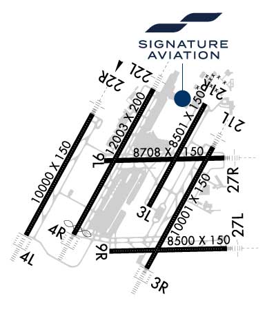
Newly renovated 24-hr. Full Service FBO w/44 year history at DTW with highly experienced Line Service Techs offering lowest priced Contract/Retail Fuel & largest FBO ramp on field, Heated Hangar, Crew Cars, Customs Circle, Pilots Lounge w/big screen TV, Exec. Catering, Conf. & Quiet rooms, Business Ctr., GPU, Lavs/Water, Maint., WIFI & WSI, Deicing, Coffee/Ice/Newspapers/Popcorn/Cookies & more.
Two locations on the east and west sides of the field. 24-Hour Full Service FBO, Heated Hangars, Free Coffee & Ice, On-Site Car Rentals, Courtesy Vehicles, U.S. Customs, AvTrip Points, Quick Turn Fueling, Certified Line Technicians, Aircraft Detailing, Cargo & Baggage Handling, Discounted Hotel Rooms, Conference Room, New Lobby and Pilot Room, Catering, Free Snacks
Sunrise / Sunset times for DETROIT METRO WAYNE COUNTY
Date
Sunrise
Sunset
04/18/24 Thursday
6:47
20:19
04/19/24 Friday
6:45
20:20
04/20/24 Saturday
6:44
20:21
04/21/24 Sunday
6:42
20:22
04/22/24 Monday
6:41
20:24
04/23/24 Tuesday
6:39
20:25
04/24/24 Wednesday
6:38
20:26
04/25/24 Thursday
6:36
20:27
04/26/24 Friday
6:35
20:28
04/27/24 Saturday
6:33
20:29
04/28/24 Sunday
6:32
20:30
04/29/24 Monday
6:31
20:31
04/30/24 Tuesday
6:29
20:32
05/01/24 Wednesday
6:28
20:34
Airport Facilities
Airport Attendance Schedule
CONTINUOUS
Airport Status
OPERATIONAL (This Status can change at any time - please check NOTAMS)
Airport Lighting Schedule
Airport Storage Available
Tie Downs, Hanger
Extra Services Available
Air Freight, Cargo Handling, Charter
Wind Indicator
YES - (lighted)
Control Tower
YES
CTAF Frequency
Unicom Frequency
122.950
Rotating Beacon Color
WG
Segmented Circle
NO
Landing Fee
YES
Airport Inspection Data
Airport Inspected
FEDERAL - performed by FAA AIRPORTS FIELD PERSONNEL
Inspection Date
08/17/2023
Airport Services
Type of Fuel Available
Grade 100LL, JET A (freeze point -40C)
Airframe Repair Service
NONE
Power Plant Repair Service
NONE
Geographic Data
Latitude
N4212.7
Longitude
W08321.2 (ESTIMATED)
Arpt Elevation
645ft (SURVEYED)
Magnetic Variation
07W
15 miles S
of DETROIT
Traffic Pattern Altitude
Sectional Chart
DETROIT
Aircraft Data
Operations (Reported)
Yearly
Avg. Daily
General Aviation Transient
4698
13
General Aviation Local
0
0
Air Taxi
26833
74
Commerical
252668
692
Commuter
0
0
Military
115
0
Aircraft based on Field
General Aviation Singles
0
General Aviation Multi
0
Jet Aircraft
9
General Aviation Helicopters
0
Military Aircraft
0
Gliders
0
Ultralights
0
FAA Services
FSS on field
NO
FSS tie-in
LANSING
FSS Phone
1-800-WX-BRIEF
Who issues Notams
DTW
Notam D service at airport
YES
ARTCC Name
CLEVELAND
Federal Status
Airport Certification
AIRPORT RECEIVING SCHEDULED AIR CARRIER SERVICE FROM CARRIERS CERTIFICATED BY THE CIVIL AERONAUTICS BOARD
Aircraft Rescue & Firefighting Index
AIRPORT HAS A CERTIFICATE UNDER CFR PART 139
Airport of Entry
YES
Custom Landing Rights
No
Joint Civil/Military
No
Military Landing rights
YES
Federal Agreements
NATIONAL PLAN OF INTEGRATED AIRPORT SYSTEMS (NPIAS)
GRANT AGREEMENTS UNDER FAAP/ADAP/AIP
SURPLUS PROPERTY AGREEMENT UNDER PUBLIC LAW 289
SURPLUS PROPERTY AGREEMENT UNDER REGULATION 16-WAA
ASSURANCES PURSUANT TO TITLE VI, CIVIL RIGHTS ACT OF 1964
Remarks
BRIGHTLY LIGHTED PARKING LOT 2.6 NM SW OF ARPT.
RY STATUS LGTS ARE IN OPN.
RWY VISUAL SCREEN 20 FT AGL 1150 FT S. AER 04R
PPR FOR B747-8 OPRS DUE TO CONSTRAINTS ON RWYS, TWYS AND RAMPS CTC AIRFIELD OPRS AT 734-942-3685.
ACFT WITH WINGSPAN GTR THAN 171 FT ARE RSTRD FM USING TWY P BTN TWY J & TWY P3.
ACFT WITH WINGSPAN GTR THAN 171 FT ARE RSTRD FM USING TWY H BTN TWY B & TWY F.
TURNING RSTRD TO WINGSPAN 135 FT OR LESS TWY G NORTH TO TWY V EAST.
DIVERSIONAIR CARRIERS WITHOUT A PRESENCE AT DTW SHOULD CTC AIRFIELD OPRS 734-942-3685 PRIOR TO DIVERTING TO THE EXTENT PRACTICAL AND PROVIDE COMPANY, FLT OPRS, CTC INFO, AIRCRAFT TYPE, PERSONS ONBOARD, INTERNATIONAL OR DOMESTIC, ANY GRND HANDLER AGGREEMENTS IN PLACE.
BE ALERT BIRDS, WATERFOWL, ON & INVOF ARPT.
AIRCRAFT WITH WINGSPAN GREATER THAN 171 FT CANNOT PASS EACH OTHER ON TWYS Y AND K BETWEEN TWYS U AND K6 INSUFFICIENT WINGTIP CLEARANCE.
TURNING RESTRICTION TWY B TO TWY K RESTRICTED TO AIRCRAFT WITH WINGSPAN 171 FT OR LESS.
AUTH TO CONDUCT SIMUL INDEPENDENT INSTR APCHS TO PARL RWY 04L/22R & 03R/21L WO FINAL MONITORS, RWY CNTRLNS SEPARATED BY 8800 FT.
ACFT ON TWY 'F' AND TWY 'V' DO NOT BLOCK FIRE STATION EXITS.
ASDE-X IN USE. OPERATE TRANSPONDERS WITH ALTITUDE REPORTING MODE AND ADS-B (IF EQUIPPED) ENABLED ON ALL AIRPORT SURFACES.
TAXI ON RWY 09L/27R LTD TO: EXITING FM RWY 04R/22L, 03L/21R, & 03R/21L EXC NO TAXI BTN RWY 03L/21R & TWY W; TWO-WAY TAXI BTN TWY Y & TWY M WHEN RED STOP BAR LGTS ARE LGTD AT RWY 04R/22L & 03L/21R OR WHEN BARRICADES ARE USED INSTEAD AT THE RESPECTIVE INTS. TAXI BTN SS-SR OR IN CONDS WITH VIS LESS THAN 1 SM RQRS GREEN CNTRLN LGT TO BE OPR.
RWY 04X/ 22XRY ID 04X/22X SUPPORTS SECOND ILS'S (I-BZB AND I-ALA) AT RY 04L/22R.
Airport Communications & Frequencies:
ATIS Frequencies: Hours(local) of Operation: CONTINUOUS
118.125 ;DEP
133.675 ;ARR
METRO Tower Frequencies: Hours(local) of operation: CONTINUOUS
Length: 8501 ft Width: 150 ft Surface: CONCRETE Edge lights: High Intensity Treatment: GROOVED Weight: PCN 86 /R/B/W/T
Runway: 03L
Runway: 21R
Mag heading:
36°
Mag heading:
216°
Rwy Slope:
-.06% Down
Rwy Slope:
.06% Up
Approach:
Approach:
Pattern:
Left Traffic
Pattern:
Left Traffic
Markings:
NONPRECISION INSTRUMENT
Markings:
NONPRECISION INSTRUMENT
Marking Condition:
GOOD
Marking Condition:
GOOD
Arresting Dev:
Arresting Dev:
Lat & Long:
N4212.5 W08321.1
Lat. & Long.:
N4213.7 W08320.2
Elev:
636.5 ft. MSL
Elev:
631.4 ft. MSL
TCH:
55 ft. AGL
TCH:
55 ft. AGL
Visual Glide Path:
3.00 degrees
Visual Glide Path:
3.00 degrees
Displaced Threshold:
No
Displaced Threshold:
No
Touchdown Zone:
YES
Touchdown Zone:
YES
Touchdown Elev.:
636.9 feet
Touchdown Elev.:
634.5 feet
Visual Glide Slope:
4-Light PAPI on RIGHT side of Runway; PAPI UNUSBL BYD 8 DEGS LEFT OR RIGHT OF CNTRLN.
Visual Glide Slope:
4-Light PAPI on LEFT side of Runway
RVR Equipment:
TOUCHDOWN-ROLLOUT
RVR Equipment:
TOUCHDOWN-ROLLOUT
RVV Equipment:
NO
RVV Equipment:
NO
Approach Lights:
Approach Lights:
REIL:
YES
REIL:
YES
Centerline Lights:
YES
Centerline Lights:
YES
Touchdown lights:
NO
Touchdown lights:
NO
Runway Category:
Runway with a Visual Approach
Runway Category:
Runway with a Visual Approach
Declared Distances:
TORA:8501' TODA:8501' ASDA:8501' LDA:8501'
Declared Distances:
TORA:8501' TODA:8501' ASDA:8501' LDA:8501'
Obstructions:
POLE
Obstructions:
POLE
Marked:
NOT Marked/Lighted
Marked:
NOT Marked/Lighted
Clearance slope:
26:1
Clearance slope:
50:1
Obstruction height:
19 feet AGL
Obstruction height:
42 feet AGL
Dist. from runway:
698 feet
Dist. from runway:
2302 feet
Centerline offset:
569 left of centerline
Centerline offset:
179 feet right of centerline
Comments:
Comments:
Runway Identification: 03R/21L
Length: 10001 ft Width: 150 ft Surface: CONCRETE Edge lights: High Intensity Treatment: GROOVED Weight: PCN 91 /R/B/W/T
Runway: 03R
Runway: 21L
Mag heading:
36°
Mag heading:
216°
Rwy Slope:
-.01% Down
Rwy Slope:
.01% Up
Approach:
ILS/DME
Approach:
ILS/DME
Pattern:
Left Traffic
Pattern:
Left Traffic
Markings:
PRECISION INSTRUMENT
Markings:
PRECISION INSTRUMENT
Marking Condition:
GOOD
Marking Condition:
GOOD
Arresting Dev:
Arresting Dev:
Lat & Long:
N4211.7 W08321.1
Lat. & Long.:
N4213.2 W08320.0
Elev:
632.8 ft. MSL
Elev:
631.8 ft. MSL
TCH:
70 ft. AGL
TCH:
80 ft. AGL
Visual Glide Path:
3.00 degrees
Visual Glide Path:
3.00 degrees
Displaced Threshold:
No
Displaced Threshold:
No
Touchdown Zone:
YES
Touchdown Zone:
YES
Touchdown Elev.:
633.1 feet
Touchdown Elev.:
632.3 feet
Visual Glide Slope:
4-Light PAPI on RIGHT side of Runway
Visual Glide Slope:
4-Light PAPI on LEFT side of Runway
RVR Equipment:
TOUCHDOWN-MIDFIELD-ROLLOUT
RVR Equipment:
TOUCHDOWN-MIDFIELD-ROLLOUT
RVV Equipment:
NO
RVV Equipment:
NO
Approach Lights:
ALSF2 - standard 2,400 foot high intensity approach lighting system with sequenced flashers, Category II or III; ALSF2 RQRD WHEN RVR/VSBLY IS 6000/1 MILE OR LESS. SSALR OPERD WHEN RVR/VSBLY IS 6000/1 MILE.
Approach Lights:
MALSR - 1,400 foot medium intensity approach lighting system with runway alignment indicator lights
REIL:
NO
REIL:
NO
Centerline Lights:
YES
Centerline Lights:
YES
Touchdown lights:
YES
Touchdown lights:
NO
Runway Category:
Precision Instrument Runway
Runway Category:
Precision Instrument Runway
Declared Distances:
TORA:10001' TODA:10001' ASDA:10001' LDA:10001'
Declared Distances:
TORA:10001' TODA:10001' ASDA:10001' LDA:10001'
Obstructions:
ROAD
Obstructions:
BERM
Marked:
NOT Marked/Lighted
Marked:
NOT Marked/Lighted
Clearance slope:
41:1
Clearance slope:
17:1
Obstruction height:
22 feet AGL
Obstruction height:
20 feet AGL
Dist. from runway:
1119 feet
Dist. from runway:
559 feet
Centerline offset:
439 left of centerline
Centerline offset:
523 feet right of centerline
Comments:
Comments:
Runway Identification: 04L/22R
Length: 10000 ft Width: 150 ft Surface: CONCRETE Edge lights: High Intensity Treatment: GROOVED Weight: PCN 126/R/B/W/T
Runway: 04L
Runway: 22R
Mag heading:
36°
Mag heading:
216°
Rwy Slope:
-.03% Down
Rwy Slope:
.03% Up
Approach:
ILS/DME
Approach:
ILS/DME
Pattern:
Left Traffic
Pattern:
Left Traffic
Markings:
PRECISION INSTRUMENT
Markings:
PRECISION INSTRUMENT
Marking Condition:
GOOD
Marking Condition:
GOOD
Arresting Dev:
Arresting Dev:
Lat & Long:
N4212.1 W08323.0
Lat. & Long.:
N4213.6 W08322.0
Elev:
645.2 ft. MSL
Elev:
642.1 ft. MSL
TCH:
71 ft. AGL
TCH:
71 ft. AGL
Visual Glide Path:
3.00 degrees
Visual Glide Path:
3.00 degrees
Displaced Threshold:
No
Displaced Threshold:
No
Touchdown Zone:
YES
Touchdown Zone:
YES
Touchdown Elev.:
645.2 feet
Touchdown Elev.:
642.1 feet
Visual Glide Slope:
4-Light PAPI on LEFT side of Runway
Visual Glide Slope:
4-Light PAPI on RIGHT side of Runway
RVR Equipment:
TOUCHDOWN-MIDFIELD-ROLLOUT
RVR Equipment:
TOUCHDOWN-MIDFIELD-ROLLOUT
RVV Equipment:
NO
RVV Equipment:
NO
Approach Lights:
ALSF2 - standard 2,400 foot high intensity approach lighting system with sequenced flashers, Category II or III
Approach Lights:
MALSR - 1,400 foot medium intensity approach lighting system with runway alignment indicator lights
REIL:
NO
REIL:
NO
Centerline Lights:
YES
Centerline Lights:
YES
Touchdown lights:
YES
Touchdown lights:
YES
Runway Category:
Precision Instrument Runway
Runway Category:
Precision Instrument Runway
Declared Distances:
TORA:10000' TODA:10000' ASDA:10000' LDA:10000'
Declared Distances:
TORA:10000' TODA:10000' ASDA:10000' LDA:10000'
Obstructions:
TREE
Obstructions:
ROAD
Marked:
NOT Marked/Lighted
Marked:
NOT Marked/Lighted
Clearance slope:
49:1
Clearance slope:
25:1
Obstruction height:
48 feet AGL
Obstruction height:
14 feet AGL
Dist. from runway:
2563 feet
Dist. from runway:
550 feet
Centerline offset:
157 right of centerline
Centerline offset:
545 feet right of centerline
Comments:
Comments:
Runway Identification: 04R/22L
Length: 12003 ft Width: 200 ft Surface: CONCRETE Edge lights: High Intensity Treatment: GROOVED Weight: PCN 126/R/B/W/T
Runway: 04R
Runway: 22L
Mag heading:
36°
Mag heading:
216°
Rwy Slope:
-.01% Down
Rwy Slope:
.01% Up
Approach:
ILS/DME
Approach:
ILS/DME
Pattern:
Left Traffic
Pattern:
Left Traffic
Markings:
PRECISION INSTRUMENT
Markings:
PRECISION INSTRUMENT
Marking Condition:
GOOD
Marking Condition:
GOOD
Arresting Dev:
Arresting Dev:
Lat & Long:
N4212.1 W08322.3
Lat. & Long.:
N4213.9 W08321.0
Elev:
637.0 ft. MSL
Elev:
635.8 ft. MSL
TCH:
TCH:
Visual Glide Path:
Visual Glide Path:
Displaced Threshold:
509 feet
Displaced Threshold:
No
Touchdown Zone:
YES
Touchdown Zone:
YES
Touchdown Elev.:
639.5 feet
Touchdown Elev.:
637.4 feet
Visual Glide Slope:
Visual Glide Slope:
RVR Equipment:
TOUCHDOWN-MIDFIELD-ROLLOUT
RVR Equipment:
TOUCHDOWN-MIDFIELD-ROLLOUT
RVV Equipment:
NO
RVV Equipment:
NO
Approach Lights:
ALSF2 - standard 2,400 foot high intensity approach lighting system with sequenced flashers, Category II or III; ALSO HAS SSALR.
Approach Lights:
MALSR - 1,400 foot medium intensity approach lighting system with runway alignment indicator lights
REIL:
NO
REIL:
NO
Centerline Lights:
YES
Centerline Lights:
YES
Touchdown lights:
YES
Touchdown lights:
NO
Runway Category:
Precision Instrument Runway
Runway Category:
Precision Instrument Runway
Declared Distances:
TORA:12003' TODA:12003' ASDA:12003' LDA:11494'
Declared Distances:
TORA:12003' TODA:12003' ASDA:12003' LDA:12003'
Obstructions:
TREE
Obstructions:
RR
Marked:
NOT Marked/Lighted
Marked:
NOT Marked/Lighted
Clearance slope:
41:1
Clearance slope:
43:1
Obstruction height:
85 feet AGL
Obstruction height:
24 feet AGL
Dist. from runway:
3652 feet
Dist. from runway:
1271 feet
Centerline offset:
852 right of centerline
Centerline offset:
616 feet left of centerline
Comments:
Comments:
Runway Identification: 09L/27R
Length: 8708 ft Width: 150 ft Surface: CONCRETE Edge lights: High Intensity Treatment: GROOVED Weight: PCN 73 /R/A/W/T
Runway: 09L
Runway: 27R
Mag heading:
96°
Mag heading:
276°
Rwy Slope:
-.04% Down
Rwy Slope:
.04% Up
Approach:
Approach:
ILS
Pattern:
Left Traffic
Pattern:
Left Traffic
Markings:
PRECISION INSTRUMENT
Markings:
PRECISION INSTRUMENT
Marking Condition:
GOOD
Marking Condition:
GOOD
Arresting Dev:
Arresting Dev:
Lat & Long:
N4213.0 W08321.8
Lat. & Long.:
N4213.1 W08319.9
Elev:
638.0 ft. MSL
Elev:
634.3 ft. MSL
TCH:
TCH:
61 ft. AGL
Visual Glide Path:
Visual Glide Path:
3.00 degrees
Displaced Threshold:
No
Displaced Threshold:
No
Touchdown Zone:
YES
Touchdown Zone:
YES
Touchdown Elev.:
639.6 feet
Touchdown Elev.:
634.7 feet
Visual Glide Slope:
Visual Glide Slope:
4-Light PAPI on LEFT side of Runway
RVR Equipment:
ROLLOUT
RVR Equipment:
TOUCHDOWN
RVV Equipment:
NO
RVV Equipment:
NO
Approach Lights:
Approach Lights:
MALSR - 1,400 foot medium intensity approach lighting system with runway alignment indicator lights
REIL:
YES
REIL:
NO
Centerline Lights:
NO
Centerline Lights:
NO
Touchdown lights:
NO
Touchdown lights:
NO
Runway Category:
Runway with a Visual Approach
Runway Category:
Precision Instrument Runway
Declared Distances:
TORA:8708' TODA:8708' ASDA:8618' LDA:8618'
Declared Distances:
TORA:8708' TODA:8708' ASDA:8708' LDA:8708'
Obstructions:
ANT
Obstructions:
BERM
Marked:
NOT Marked/Lighted
Marked:
NOT Marked/Lighted
Clearance slope:
40:1
Clearance slope:
19:1
Obstruction height:
107 feet AGL
Obstruction height:
7 feet AGL
Dist. from runway:
4461 feet
Dist. from runway:
333 feet
Centerline offset:
461 right of centerline
Centerline offset:
373 feet right of centerline
Comments:
Comments:
Runway Identification: 09R/27L
Length: 8500 ft Width: 150 ft Surface: CONCRETE-FAIR CONDITION Edge lights: High Intensity Treatment: GROOVED Weight: PCN 78 /R/A/W/T
Runway: 09R
Runway: 27L
Mag heading:
96°
Mag heading:
276°
Rwy Slope:
-.08% Down
Rwy Slope:
.08% Up
Approach:
Approach:
ILS/DME
Pattern:
Left Traffic
Pattern:
Left Traffic
Markings:
PRECISION INSTRUMENT
Markings:
PRECISION INSTRUMENT
Marking Condition:
GOOD
Marking Condition:
GOOD
Arresting Dev:
Arresting Dev:
Lat & Long:
N4211.9 W08321.7
Lat. & Long.:
N4212.0 W08319.8
Elev:
636.0 ft. MSL
Elev:
629.0 ft. MSL
TCH:
TCH:
71 ft. AGL
Visual Glide Path:
Visual Glide Path:
3.00 degrees
Displaced Threshold:
No
Displaced Threshold:
No
Touchdown Zone:
YES
Touchdown Zone:
YES
Touchdown Elev.:
636.1 feet
Touchdown Elev.:
630.1 feet
Visual Glide Slope:
Visual Glide Slope:
4-Light PAPI on LEFT side of Runway
RVR Equipment:
ROLLOUT
RVR Equipment:
TOUCHDOWN
RVV Equipment:
NO
RVV Equipment:
NO
Approach Lights:
Approach Lights:
MALSR - 1,400 foot medium intensity approach lighting system with runway alignment indicator lights