KDTS

DESTIN-FORT WALTON BEACH
DESTIN
FL
Time Zone: Central
Lat: N 3024.0
Long: W 08628.3
Elev: 23
Var: +01
Longest Runway: 5001
Clr Del: 127.7 TW CLD
Dept. ATIS: 133.92
Arr. ATIS: 133.92
AWOS: 133.92
Ground: 121.6
Tower: 118.45
Click here for more info.

FBO & Flight Services info for KDTS

FBOs: Update your Fuel Prices
Atlantic Aviation is your premier aviation service provider with more than 100 locations in North America, including Hawaii and the Caribbean. We provide standard ground services you'd expect, with a detailed focus on ensuring an unforgettable customer experience.
Ph: 850-424-6890 Fax: 850-424-3075 Freq: 130.05WebsiteE-Mail
                                       
Service
Jet
100LL
SAF
MoGas
Fuel Avail: Call out fee for after hours. 850-830-0494
Full7.757.45    Last Update: 04/19/2024 13:29:54

Jet A plus FSII + $0.09
Self        
Misc. Info: Address: 1001 AIRPORT ROAD BUILDING 15,   DESTIN, FL 32541

ASOSPh: 850-654-7128
-
Freq: 133.92  
If you are an FBO, call 1-203-262-1700 to update your info or email: FltPlan.Advertising@garmin.com
Advertise your FBO on FltPlan.com

Runway & Approach Info for KDTS
Rwy
Length
Land Dist**
Approach*
  Rwy
Length
Land Dist**
Approach*
14
5001x100  5001'          
 
  
32
  5001x100  5001'          
 
 * only ILS, LOC, LDA, and SDF approaches to a specific runway are shown
** For any Declared Landing Distance Available, please see A/FD or Approach plates
Runway Weight Capability (lbs.) Help
Runway IDSingle WheelDouble WheelDouble Tandem WheelDual Double Wheel
14/3238,00067,000113,000N/A
These numbers are Advisory and are not limits.   The Airport Manager should have more accurate Weight Limits
Approach Charts
Approaches    
Current Weather/Notams
Customs Information Send updates to Support@FltPlan.com
Customs Not Available
Database effective 04/18/2024
Airport Diagram of KDTS
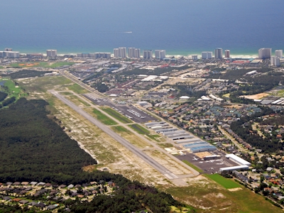
Airport Diagram might not be current.

Facility Name: DESTIN EXEC
City Name: DESTIN
County: OKALOOSA
State abbrev: FL
State Name: FLORIDA
   
Ownership: PUBLICLY OWNED
Use: OPEN TO THE PUBLIC
Owner's Name: OKALOOSA CO
Address: BOARD OF COMMISSIONERS, 101 EAST JAMES LEE BOULEVARD
 CRESTVIEW, FL 32536
Owner's Phone: 850-689-5000
  
Manager's Name: TRACY STAGE
Address: 1701 STATE ROAD 85 NORTH
 EGLIN AFB, FL 32542-1413
Phone: 850-651-7160; EXT 4
   
FAA Region: SOUTHERN
FAA Field Office: ORL
Photo courtesy of Scott Jackson photosflorida.com


Click here for full scale & interactive Sectional view of KDTS


Sunrise / Sunset times for DESTIN EXEC

DateSunriseSunset
04/18/24 Thursday6:1519:16
04/19/24 Friday6:1419:17
04/20/24 Saturday6:1219:17
04/21/24 Sunday6:1119:18
04/22/24 Monday6:1019:19
04/23/24 Tuesday6:0919:19
04/24/24 Wednesday6:0819:20
04/25/24 Thursday6:0719:21
04/26/24 Friday6:0619:21
04/27/24 Saturday6:0519:22
04/28/24 Sunday6:0419:22
04/29/24 Monday6:0419:23
04/30/24 Tuesday6:0319:24
05/01/24 Wednesday6:0219:24

Airport Facilities

Airport Attendance Schedule7 Days A Week 0600-2200
Airport Status OPERATIONAL (This Status can change at any time - please check NOTAMS)
Airport Lighting ScheduleACTVT HIRL RWY 14/32 - CTAF.
Airport Storage AvailableTie Downs
Extra Services AvailableAvionics, Flight Instruction, Aircraft Rental
Wind IndicatorYES - (lighted)
Control TowerYES
CTAF Frequency118.450
Unicom Frequency123.075
Rotating Beacon ColorWG
Segmented CircleY-L
Landing FeeNO

Airport Inspection Data

Airport InspectedSTATE - performed by STATE AERONAUTICAL PERSONNEL
Inspection Date03/06/2018

Airport Services

Type of Fuel AvailableGrade 100LL, JET A (freeze point -40C)
Airframe Repair ServiceMAJOR
Power Plant Repair ServiceMAJOR

Geographic Data

LatitudeN3024.0
LongitudeW08628.3 (ESTIMATED)
Arpt Elevation22ft (SURVEYED)
Magnetic Variation01W
1 miles Eof DESTIN
Traffic Pattern Altitude
Sectional ChartNEW ORLEANS

Aircraft Data

Operations (Reported)YearlyAvg. Daily
General Aviation Transient 51323141
General Aviation Local 1164932
Air Taxi 6542
Commerical 00
Commuter 00
Military 3611
Aircraft based on Field
General Aviation Singles 54
General Aviation Multi 15
Jet Aircraft 21
General Aviation Helicopters 6
Military Aircraft 0
Gliders 0
Ultralights 0

FAA Services

FSS on field NO
FSS tie-in GAINESVILLE
FSS Phone 1-800-WX-BRIEF
Who issues Notams DTS
Notam D service at airport YES
ARTCC Name JACKSONVILLE

Federal Status

Airport Certification
Aircraft Rescue & Firefighting IndexNone
Airport of EntryNo
Custom Landing RightsNo
Joint Civil/MilitaryNo
Military Landing rightsYES

Federal Agreements

NATIONAL PLAN OF INTEGRATED AIRPORT SYSTEMS (NPIAS)
GRANT AGREEMENTS UNDER FAAP/ADAP/AIP
ASSURANCES PURSUANT TO TITLE VI, CIVIL RIGHTS ACT OF 1964

Remarks

EXERCISE VIGILANCE DUE TO CLOSE PROXIMITY TO EGLIN AFB LCTD 6 NM NW.
ALL ACFT CTC EGLIN CD ON 127.7 FOR ATC DEP INSTR PRIOR TO TKOF WHEN TWR CLSD.
WHEN TWR CLSD; IFR ACFT RMN ON GND & CTC DEP CTL FOR CLIMB OUT INSTR & IFR RLS.
ARPT COND UNMON.
PARASAILING & BANNER TOWING WI 5 NM.
CAUTION: MEN & EQUIP ON & INVOF SAFETY AREA.
Airport Communications & Frequencies:
ATIS Frequencies:   Hours(local) of Operation: 24 HRS
133.925
DESTIN Tower Frequencies:   Hours(local) of operation: 0600-2200   
118.45
DESTIN Ground Frequencies:
121.6
Clearance Delivery Frequencies:
121.6
127.7 WHEN TWR CLSD
377.2
CTAF Frequency:
118.450
Unicom Frequency:
123.075
EGLIN Primary Approach Frequencies:  
132.1
360.6
EGLIN Primary Departure Frequencies:  
132.1
360.6
Runway Identifications
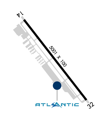
Runway Identification: 14/32
Length: 5001 ft
Width: 100 ft
Surface: ASPHALT-GOOD CONDITION
Edge lights: High Intensity

Treatment: NONE
Weight: PCN 25 /F/B/W/T

 Runway: 14   Runway: 32
Mag heading: 143°Mag heading: 323°
Rwy Slope: -.02% DownRwy Slope: .02% Up
Approach: Approach:
Pattern: Left TrafficPattern: Left Traffic
Markings: NONPRECISION INSTRUMENTMarkings: NONPRECISION INSTRUMENT
Marking Condition: GOODMarking Condition: GOOD
Arresting Dev: Arresting Dev:
Lat & Long: N3024.3  W08628.6Lat. & Long.: N3023.7  W08628.0
Elev: 22.2 ft. MSLElev: 21.0 ft. MSL
TCH: 43 ft. AGLTCH: 42 ft. AGL
Visual Glide Path: 3.00 degreesVisual Glide Path: 3.00 degrees
Displaced Threshold: NoDisplaced Threshold: No
Touchdown Zone: YESTouchdown Zone: YES
Touchdown Elev.: 22.6 feetTouchdown Elev.: 21.6 feet
Visual Glide Slope: 4-Light PAPI on LEFT side of Runway; RWY 14 PAPI UNA BYD 6 DEG L OF RCL.Visual Glide Slope: 4-Light PAPI on LEFT side of Runway; RWY 32 PAPI UNUSABLE BEYOND 7 DEGREES LEFT AND RIGHT OF CNTRLN.
RVR Equipment: RVR Equipment:
RVV Equipment: NORVV Equipment: NO
Approach Lights: Approach Lights:
REIL: NOREIL: NO
Centerline Lights: NOCenterline Lights: NO
Touchdown lights: NOTouchdown lights: NO
Runway Category: Runway with a Non-precision Approach having visibility minimums greater than 3/4 mileRunway Category: Runway with a Non-precision Approach having visibility minimums greater than 3/4 mile
Declared Distances: Declared Distances:
Obstructions: TREESObstructions: BLDG
Marked: NOT Marked/LightedMarked: LIGHTED
Clearance slope: 34:1Clearance slope: 40:1
Obstruction height: 39 feet AGLObstruction height: 116 feet AGL
Dist. from runway: 1540 feetDist. from runway: 4855 feet
Centerline offset: 45 right of centerlineCenterline offset: 325 feet right of centerline
Comments: Comments:
C:204/P: