Click here for more info on on SMS!

KDTG

DWIGHT AERO
DWIGHT
IL
Time Zone: Central
Lat: N 4108.0
Long: W 08826.3
Elev: 632
Var: +02
Longest Runway: 2364
CTAF: 122.8

FBO & Flight Services info for KDTG

FBOs: Update your Fuel Prices

DWIGHT AEROPh: 815-584-2486
-
-
Service
Jet
100LL
SAF
MoGas
Fuel Avail: ~~FLIGHT SCHOOL
Full        Last Update: 04/16/2024 05:50:17

Self        
 Address: ~~FLIGHT SCHOOL ONLY
If you are an FBO, call 1-203-262-1700 to update your info or email: FltPlan.Advertising@garmin.com
Advertise your FBO on FltPlan.com

Runway & Approach Info for KDTG
Rwy
Length
Land Dist**
Approach*
  Rwy
Length
Land Dist**
Approach*
09
2364x21  2364'          
 
  
27
  2364x21  2064'          
 
18
1900x100  1900'          
 
  
36
  1900x100  1900'          
 
 * only ILS, LOC, LDA, and SDF approaches to a specific runway are shown
** For any Declared Landing Distance Available, please see A/FD or Approach plates
Runway Weight Capability (lbs.) Help
Runway IDSingle WheelDouble WheelDouble Tandem WheelDual Double Wheel
09/27N/AN/AN/AN/A
18/36N/AN/AN/AN/A
These numbers are Advisory and are not limits.   The Airport Manager should have more accurate Weight Limits
Approach Charts
FltPlan does not have IFR approach charts available for KDTG.
Current Weather/Notams
Customs Information Send updates to Support@FltPlan.com
Customs Not Available
Database effective 04/18/2024
Airport Diagram of KDTG
Airport Diagram might not be current.

Facility Name: DWIGHT
City Name: DWIGHT
County: GRUNDY
State abbrev: IL
State Name: ILLINOIS
   
Ownership: PRIVATELY OWNED
Use: OPEN TO THE PUBLIC
Owner's Name: DWIGHT AERO SERVICE; C/O DEANNA SCHAFF (MAJORITY SHARE HOLDER) EMAIL ADDRESS: DEANNASCHAFF@AOL.COM (ALL LOWER CASE).
Address: 6034 E CAMBRIDGE AVENUE
 SCOTTSDALE, AZ 85257
Owner's Phone: (602) 319-3319
  
Manager's Name: DAN RIBORDY
Address: PO BOX 214; EMAIL ADDRESS: DTGAERO@GMAIL.COM (ALL LOWER CASE)
 DWIGHT, IL 60420
Phone: (815) 374-4319
   
FAA Region: GREAT LAKES
FAA Field Office: CHI


Sunrise / Sunset times for DWIGHT

DateSunriseSunset
04/15/24 Monday6:1319:35
04/16/24 Tuesday6:1219:36
04/17/24 Wednesday6:1019:37
04/18/24 Thursday6:0919:38
04/19/24 Friday6:0719:39
04/20/24 Saturday6:0619:40
04/21/24 Sunday6:0419:41
04/22/24 Monday6:0319:42
04/23/24 Tuesday6:0119:43
04/24/24 Wednesday6:0019:44
04/25/24 Thursday5:5919:45
04/26/24 Friday5:5719:46
04/27/24 Saturday5:5619:47
04/28/24 Sunday5:5419:48

Airport Facilities

Airport Attendance ScheduleUNATTENDED
Airport Status OPERATIONAL (This Status can change at any time - please check NOTAMS)
Airport Lighting ScheduleFOR LIRL RY 09/27 AFTER 2200 CALL 815-258-8218.; FOR ROTG BCN CALL 815-258-8218.
Airport Storage AvailableTie Downs, Hanger
Extra Services AvailableFlight Instruction, Aircraft Rental
Wind IndicatorYES - (unlit)
Control TowerNO
CTAF Frequency122.800
Unicom Frequency122.800
Rotating Beacon ColorWG
Segmented CircleNO
Landing FeeNO

Airport Inspection Data

Airport InspectedSTATE - performed by STATE AERONAUTICAL PERSONNEL
Inspection Date08/12/2022

Airport Services

Type of Fuel AvailableGrade 100LL
Airframe Repair ServiceNone
Power Plant Repair ServiceNone

Geographic Data

LatitudeN4108.0
LongitudeW08826.3 (ESTIMATED)
Arpt Elevation632ft (ESTIMATED)
Magnetic Variation02W
3 miles Nof DWIGHT
Traffic Pattern Altitude800
Sectional ChartCHICAGO

Aircraft Data

Operations (Reported)YearlyAvg. Daily
General Aviation Transient 6502
General Aviation Local 13504
Air Taxi 00
Commerical 00
Commuter 00
Military 00
Aircraft based on Field
General Aviation Singles 9
General Aviation Multi 0
Jet Aircraft 0
General Aviation Helicopters 0
Military Aircraft 0
Gliders 0
Ultralights 2

FAA Services

FSS on field NO
FSS tie-in KANKAKEE
FSS Phone 1-800-WX-BRIEF
Who issues Notams IKK
Notam D service at airport YES
ARTCC Name CHICAGO

Federal Status

Airport Certification
Aircraft Rescue & Firefighting IndexNone
Airport of EntryNo
Custom Landing RightsNo
Joint Civil/MilitaryNo
Military Landing rightsNo

Remarks

FOR CD CTC CHICAGO ARTCC AT 630-906-8921.
RWY 09/2 7 21' ASPH STRIP CENTERED ON 100' TURF STRIP.
RWY 09/2 7 RY 09/27 NSTD LIRL; NOT FAA APPROVED L-800 SERIES. SPACING & INTST OF LGTS VARY.
Airport Communications & Frequencies:
CTAF Frequency:
122.800
Unicom Frequency:
122.800
Remarks
  • APCH/DEP SVC PRVDD BY CHICAGO ARTCC (ZAU) ON FREQS 123.75/259.1 (MAZON RCAG).
  • Runway Identifications
    Runway Identification: 09/27
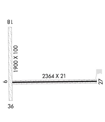
    Length: 2364 ft
    Width: 21 ft
    Surface: ASPHALT GRASS-GOOD CONDITION
    Edge lights: Non-Standard Lighting System

    Treatment: NONE

     Runway: 09   Runway: 27
    Mag heading: 90°Mag heading: 270°
    Rwy Slope: -.25% DownRwy Slope: .25% Up
    Approach: Approach:
    Pattern: Left TrafficPattern: Left Traffic
    Markings: NONSTANDARDMarkings: NONSTANDARD
    Marking Condition: GOOD; 09/27 NSTD MKGS DUE TO NARROW WIDTH.Marking Condition: GOOD
    Arresting Dev: Arresting Dev:
    Lat & Long: N4108.0  W08826.6Lat. & Long.: N4108.0  W08826.1
    Elev: 629.0 ft. MSLElev: 623.0 ft. MSL
    TCH: TCH:
    Visual Glide Path: Visual Glide Path:
    Displaced Threshold: NoDisplaced Threshold: 300 feet
    Touchdown Zone: YESTouchdown Zone: YES
    Touchdown Elev.: 629.0 feetTouchdown Elev.: 629.0 feet
    Visual Glide Slope: Visual Glide Slope:
    RVR Equipment: RVR Equipment:
    RVV Equipment: NORVV Equipment: NO
    Approach Lights: Approach Lights:
    REIL: NOREIL: NO
    Centerline Lights: NOCenterline Lights: NO
    Touchdown lights: NOTouchdown lights: NO
    Runway Category: Runway with a Visual ApproachRunway Category: Runway with a Non-precision Approach
    Declared Distances: Declared Distances:
    Obstructions: Obstructions: BLDG
    Marked: Marked: NOT Marked/Lighted
    Clearance slope: 20:1Clearance slope: 11:1; APCH RATIO TO DSPLCD THR 40:1; APCH RATIO TO DSPLCD THR OVER 16 FT BLDG 236 FT R OF CNTRLN 1 FT BACK FM DSPLCD THR 0:1.
    Obstruction height: Obstruction height: 17 feet AGL
    Dist. from runway: Dist. from runway: 389 feet
    Centerline offset: Centerline offset: 332 feet right of centerline
    Comments: Comments: 15 FT RD 185 FT FM RY END 0B CNTRLN; NUMEROUS BLDGS R OF CNTRLN +299 FT IN FRONT 164 FT IN BACK OF THE RY END WITH MAX TOP AT 20 FT 237 FT RIGHT OF CNTRLN & 106 FT IN FRONT OF RY END.
    Runway Identification: 18/36
    Length: 1900 ft
    Width: 100 ft
    Surface: GRASS-GOOD CONDITION
    Edge lights:

    Treatment: NONE

     Runway: 18   Runway: 36
    Mag heading: N/AMag heading: N/A
    Approach: Approach:
    Pattern: Left TrafficPattern: Left Traffic
    Markings: NONEMarkings: NONE
    Marking Condition: Marking Condition:
    Arresting Dev: Arresting Dev:
    Lat & Long:   Lat. & Long.:   
    Elev: N/AElev: N/A
    TCH: TCH:
    Visual Glide Path: Visual Glide Path:
    Displaced Threshold: NoDisplaced Threshold: No
    Touchdown Zone: NOTouchdown Zone: NO
    Touchdown Elev.: Touchdown Elev.:
    Visual Glide Slope: Visual Glide Slope:
    RVR Equipment: RVR Equipment:
    RVV Equipment: NORVV Equipment: NO
    Approach Lights: Approach Lights:
    REIL: NOREIL: NO
    Centerline Lights: NOCenterline Lights: NO
    Touchdown lights: NOTouchdown lights: NO
    Runway Category: Runway with a Visual ApproachRunway Category: Runway with a Visual Approach
    Declared Distances: Declared Distances:
    C:/P: