Click here for more info on on SMS!

KDSM

DES MOINES INTL
DES MOINES
IA
Time Zone: Central
Lat: N 4132.0
Long: W 09339.8
Elev: 958
Var: -01
Longest Runway: 9004
Clr Del: 134.15
Dept. ATIS: 119.55
Arr. ATIS: 119.55
Ground: 121.9
Tower: 118.3

FBO & Flight Services info for KDSM

FBOs: Update your Fuel Prices

  click here  
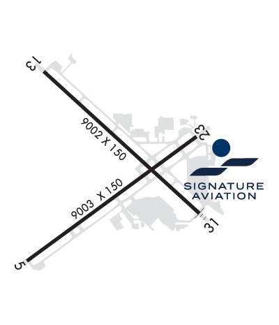
As Iowa's capital city, Des Moines is a hub of government action, business activity, arts & culture. Affordable housing, one of the nation's shortest average commute times, & a diverse population, make Des Moines a wonderful place to live, work & visit. With quality service and competitive pricing, Signature-Des Moines welcomes you 24 hours a day, 7 days a week to handle your travel needs.
Ph: 515-256-5330 Fax: 515-256-5326 Freq: 131.0WebsiteE-Mail
                                       
Service
Jet
100LL
SAF
MoGas
Fuel Avail: Jet A w/Prist .06 more
Full7.327.25    Last Update: 04/18/2024 12:04

Self        
Misc. Info: Address: 6213 SW 28TH ST   DES MOINES, IA 50321

MODERN AVIATIONPh: 515-285-6551 Fax: 515-285-7251 Freq: 130.57
Service
Jet
100LL
SAF
MoGas
Fuel Avail: 24/7
Full7.277.25    Last Update: 04/16/2024 08:46  
Self        
 Address: 2700 MCKINLEY AVE.   DES MOINES, IA 50315
ASOSPh: 515-974-8013
-
-
 
ATISPh: 515-287-3180
-
Freq: 119.55  
If you are an FBO, call 1-203-262-1700 to update your info or email: FltPlan.Advertising@garmin.com
Advertise your FBO on FltPlan.com

Runway & Approach Info for KDSM
Rwy
Length
Land Dist**
Approach*
  Rwy
Length
Land Dist**
Approach*
05
9004x150  9004'          
ILS/DME
 111.50 - 052°  
  
23
  9004x150  9004'          
 
13
9001x150  9001'          
ILS/DME
 111.90 - 131°  
  
31
  9001x150  9001'          
ILS/DME
 110.30 - 311°  
 * only ILS, LOC, LDA, and SDF approaches to a specific runway are shown
** For any Declared Landing Distance Available, please see A/FD or Approach plates
Runway Weight Capability (lbs.) Help
Runway IDSingle WheelDouble WheelDouble Tandem WheelDual Double Wheel
05/23100,000190,000360,000850,000
13/31100,000200,000360,000850,000
These numbers are Advisory and are not limits.   The Airport Manager should have more accurate Weight Limits
Approach Charts
Approaches    
Current Weather/Notams
Customs Information Send updates to Support@FltPlan.com
Phone 515-284-4403
Fax 515-256-5514

Comments Mon-Fri 0830-1700 *3 hrs advance notice required *Maximum passengers per flight: 15 *Call CBP directly prior to 1700 on preceeding weekday *Fax pilot crew and pax information prior to arrival
Database effective 04/18/2024
Airport Diagram of KDSM
Airport Diagram might not be current.

Facility Name: DES MOINES INTL
City Name: DES MOINES
County: POLK
State abbrev: IA
State Name: IOWA
   
Ownership: PUBLICLY OWNED
Use: OPEN TO THE PUBLIC
Owner's Name: DES MOINES AIRPORT AUTHORITY
Address: 5800 FLEUR DRIVE, SUITE 207, ROOM 201
 DES MOINES, IA 50321
Owner's Phone: 515-256-5100
  
Manager's Name: MR. KEVIN FOLEY; EXECUTIVE DIRECTOR
Address: 5800 FLEUR DRIVE, SUITE 207
 DES MOINES, IA 50321-2854
Phone: 515-256-5100
   
FAA Region: CENTRAL
FAA Field Office: NONE


Sunrise / Sunset times for DES MOINES INTL

DateSunriseSunset
04/18/24 Thursday6:2919:59
04/19/24 Friday6:2720:00
04/20/24 Saturday6:2620:01
04/21/24 Sunday6:2420:03
04/22/24 Monday6:2320:04
04/23/24 Tuesday6:2220:05
04/24/24 Wednesday6:2020:06
04/25/24 Thursday6:1920:07
04/26/24 Friday6:1720:08
04/27/24 Saturday6:1620:09
04/28/24 Sunday6:1520:10
04/29/24 Monday6:1320:11
04/30/24 Tuesday6:1220:12
05/01/24 Wednesday6:1120:13

Airport Facilities

Airport Attendance ScheduleCONTINUOUS
Airport Status OPERATIONAL (This Status can change at any time - please check NOTAMS)
Airport Lighting Schedule
Airport Storage AvailableTie Downs, Hanger
Extra Services AvailableAir Freight, Air Ambulance, Avionics, Cargo Handling, Charter, Aircraft Sales, Annual Surveying
Wind IndicatorYES - (lighted)
Control TowerYES
CTAF Frequency
Unicom Frequency122.950
Rotating Beacon ColorWG
Segmented CircleNO
Landing FeeNO

Airport Inspection Data

Airport InspectedFEDERAL - performed by FAA AIRPORTS FIELD PERSONNEL
Inspection Date06/08/2023

Airport Services

Type of Fuel AvailableGrade 100LL, JET A (freeze point -40C)
Airframe Repair ServiceMAJOR
Power Plant Repair ServiceMAJOR

Geographic Data

LatitudeN4132.0
LongitudeW09339.8 (ESTIMATED)
Arpt Elevation957ft (SURVEYED)
Magnetic Variation01E
3 miles SWof DES MOINES
Traffic Pattern Altitude
Sectional ChartOMAHA

Aircraft Data

Operations (Reported)YearlyAvg. Daily
General Aviation Transient 2310063
General Aviation Local 1525342
Air Taxi 676519
Commerical 2968181
Commuter 00
Military 23536
Aircraft based on Field
General Aviation Singles 63
General Aviation Multi 16
Jet Aircraft 23
General Aviation Helicopters 3
Military Aircraft 0
Gliders 0
Ultralights 0

FAA Services

FSS on field NO
FSS tie-in FORT DODGE
FSS Phone 1-800-WX-BRIEF
Who issues Notams DSM
Notam D service at airport YES
ARTCC Name MINNEAPOLIS

Federal Status

Airport CertificationAIRPORT RECEIVING SCHEDULED AIR CARRIER SERVICE FROM CARRIERS CERTIFICATED BY THE CIVIL AERONAUTICS BOARD
Aircraft Rescue & Firefighting IndexAIRPORT HAS A CERTIFICATE UNDER CFR PART 139
Airport of EntryNo
Custom Landing RightsYES; FLIGHT NOTIFICATION SERVICE (ADCUS) AVBL MON-FRI 0830-1700. FOR SAT; SUN; HOLS & NIGHT CUSTOMS SVC MAKE APPOINTMENTS MON-FRI 0830-1700. AT LEAST 3 HR ADVANCE NOTICE RQRD.
Joint Civil/MilitaryNo
Military Landing rightsYES

Federal Agreements

NATIONAL PLAN OF INTEGRATED AIRPORT SYSTEMS (NPIAS)
GRANT AGREEMENTS UNDER FAAP/ADAP/AIP
ASSURANCES PURSUANT TO TITLE VI, CIVIL RIGHTS ACT OF 1964
AGREEMENT UNDER DLAND OR DCLA HAS EXPIRED.

Remarks

CONTRACT FUEL AVBL; CTC SIGNATURE FLIGHT SUPPORT 515-256-5330.
BIRDS ON & INVOF ARPT.
INFORMAL NOISE ABATEMENT PROCEDURES IN EFFECT. EXPECT ATC TO ASSIGN PREFERRED RY.
IANG SOUTH RAMP PCN 78 R/B/W/T. IANG WEST RAMP PCN 87 R/B/W/T.
MAX ACFT WT SOUTH GA APRN 170,000 LBS ALL OTHER FBO APRN 80,000 LBS.
TWR HAS LIMITED VISIBILITY ON TWY P AT TWY P-7 AND AER 05.
CROSS BLEED ENGINE STARTS ON AIR CARRIER RAMP PROHIBITED.
USE CAUTION WHEN LNDG OVER RAISED LIGHTS IN THE OVERRUNS AND RWY THLDS AT DSM.
ARNG RAMP AVBL FOR MIL AND MIL-CONTRACTED ACFT FOR OFFL BUS ONLY WITH LTD SUPPORT. PPR RQR; CTC IAARNG C-12 FIXED WING DETACHMENT. DSN 431-4993, C515-252-4993 OR DSN 261-8360, C515-261-8360. FBOS WILL PRVFD TRANSIT SVCS. MIL CREWS CAN CTC HAWKI ON 252.9
A321 ACFT LTD TO 190,000 LBS ON RWY 5-23 AND TWY P.
UPDTD: SKED A321 ACFT OVER 200,000 LBS RQR AN OVERWEIGHT ACFT PMT; CTC ARPT AUTH 515-256-5000
MODERN AVIATION FBO LCTD AT NORTH GA APRON.
TERMINAL APRON TAXILANE ADG III AC ONLY, ADG IV AC AT GATE A4 ONLY.
TRML APRON TAXILANE ADG III (ACFT WINGSPAN LESS THAN 118 FT) ONLY, ADG IV (ACFT WINGSPAN LESS THAN 172 FT) ACFT AT GATE A4 ONLY.
RWY 05/2 3 PCR VALUE: 696/R/D/W/T
RWY 13/3 1 PCR VALUE: 696/R/D/W/T
Airport Communications & Frequencies:
ATIS Frequencies:   Hours(local) of Operation: CONTINUOUS
119.55
DES MOINES Tower Frequencies:   Hours(local) of operation: CONTINUOUS   
118.3
257.8
DES MOINES Ground Frequencies:
121.9
348.6
Clearance Delivery Frequencies:
134.15
317.55
Emergency Frequencies:
121.5
243.0
Unicom Frequency:
122.950
Remarks
  • CONTACT GND CONTROL ON 121.9 PRIOR TO PUSHBACK ON THE TERMINAL APRON.
  • DES MOINES Primary Approach Frequencies:   Hours(local) of operation: CONTINUOUS   
    123.9
    307.15
    Part-time Approach Frequencies:  
    120.45
    135.2
    350.3
    360.7
    DES MOINES Primary Departure Frequencies:   Hours(local) of operation: CONTINUOUS   
    123.9
    307.15
    Part-time Departure Frequencies:  
    120.45
    350.3
    Class C Frequencies:
    120.45
    123.9
    135.2
    307.15
    350.3
    360.7
    Runway Identifications
    Runway Identification: 05/23
    Length: 9004 ft
    Width: 150 ft
    Surface: CONCRETE
    Edge lights: High Intensity

    Treatment: NONE

     Runway: 05   Runway: 23
    Mag heading: 53°Mag heading: 233°
    Rwy Slope: .24% UpRwy Slope: -.24% Down
    Approach: ILS/DMEApproach:
    Pattern: Left TrafficPattern: Left Traffic
    Markings: NONPRECISION INSTRUMENTMarkings: NONPRECISION INSTRUMENT
    Marking Condition: GOODMarking Condition: GOOD
    Arresting Dev: Arresting Dev:
    Lat & Long: N4131.4  W09340.6Lat. & Long.: N4132.3  W09339.0
    Elev: 915.5 ft. MSLElev: 937.0 ft. MSL
    TCH: 55 ft. AGLTCH: 60 ft. AGL
    Visual Glide Path: 3.00 degreesVisual Glide Path: 3.00 degrees
    Displaced Threshold: NoDisplaced Threshold: No
    Touchdown Zone: YESTouchdown Zone: YES
    Touchdown Elev.: 931.2 feetTouchdown Elev.: 939.6 feet
    Visual Glide Slope: 4-Light PAPI on LEFT side of RunwayVisual Glide Slope: 4-Light PAPI on LEFT side of Runway; PAPI UNUSBL BYD 9 DEGS RIGHT OF CNTRLN.
    RVR Equipment: TOUCHDOWNRVR Equipment: ROLLOUT
    RVV Equipment: NORVV Equipment: NO
    Approach Lights: MALSR - 1,400 foot medium intensity approach lighting system with runway alignment indicator lightsApproach Lights:
    REIL: YESREIL: YES
    Centerline Lights: NOCenterline Lights: NO
    Touchdown lights: NOTouchdown lights: NO
    Runway Category: Precision Instrument RunwayRunway Category: Runway with a Non-precision Approach having visibility minimums greater than 3/4 mile
    Declared Distances: Declared Distances:
    Obstructions: Obstructions: POLE
    Marked: Marked: LIGHTED
    Clearance slope: 50:1Clearance slope: 34:1
    Obstruction height: Obstruction height: 67 feet AGL
    Dist. from runway: Dist. from runway: 2322 feet
    Centerline offset: Centerline offset: 375 feet left of centerline
    Comments: Comments:
    Runway Identification: 13/31
    Length: 9001 ft
    Width: 150 ft
    Surface: CONCRETE
    Edge lights: High Intensity

    Treatment: GROOVED

     Runway: 13   Runway: 31
    Mag heading: 131°Mag heading: 311°
    Rwy Slope: .50% UpRwy Slope: -.50% Down
    Approach: ILS/DMEApproach: ILS/DME
    Pattern: Left TrafficPattern: Right Traffic
    Markings: PRECISION INSTRUMENTMarkings: PRECISION INSTRUMENT
    Marking Condition: GOODMarking Condition: GOOD
    Arresting Dev: Arresting Dev:
    Lat & Long: N4132.7  W09340.5Lat. & Long.: N4131.7  W09339.0
    Elev: 912.6 ft. MSLElev: 957.8 ft. MSL
    TCH: 54 ft. AGLTCH: 52 ft. AGL
    Visual Glide Path: 3.00 degreesVisual Glide Path: 3.00 degrees
    Displaced Threshold: NoDisplaced Threshold: No
    Touchdown Zone: YESTouchdown Zone: YES
    Touchdown Elev.: 923.5 feetTouchdown Elev.: 957.8 feet
    Visual Glide Slope: 4-Light PAPI on RIGHT side of RunwayVisual Glide Slope: 4-Light PAPI on LEFT side of Runway
    RVR Equipment: TOUCHDOWN-MIDFIELD-ROLLOUTRVR Equipment: TOUCHDOWN-MIDFIELD-ROLLOUT
    RVV Equipment: NORVV Equipment: NO
    Approach Lights: MALSR - 1,400 foot medium intensity approach lighting system with runway alignment indicator lightsApproach Lights: ALSF2 - standard 2,400 foot high intensity approach lighting system with sequenced flashers, Category II or III
    REIL: NOREIL: NO
    Centerline Lights: YESCenterline Lights: YES
    Touchdown lights: NOTouchdown lights: YES
    Runway Category: Precision Instrument RunwayRunway Category: Precision Instrument Runway
    Declared Distances: TORA:9001' TODA:9001' ASDA:9001' LDA:9001'Declared Distances: TORA:9001' TODA:9001' ASDA:9001' LDA:9001'
    C:160/P: