| |||||||||||||||||||||||||||||||||||||||||||||||||||||||||||||||||||||
| |||||||||||||||||||||||||||||||||||||||||||||||||||||||||||||||||||||
| |||||||||||||||||||||||||||||||||||||||||||||||||||||||||||||||||||||
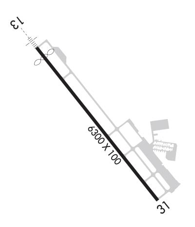
| Rwy | Rwy | |||||||
| 6300x100 | 6000' | 111.90 - 132° | 6300x100 | 6300' | ||||
| Runway ID | Single Wheel | Double Wheel | Double Tandem Wheel | Dual Double Wheel |
| 13/31 | 35,000 | 65,000 | 110,000 | N/A |
| H1 | N/A | N/A | N/A | N/A |
| H2 | N/A | N/A | N/A | N/A |
| These numbers are Advisory and are not limits. The Airport Manager should have more accurate Weight Limits | ||||
 Airport Diagram might not be current. | |
| Facility Name: | DEL RIO INTL |
| City Name: | DEL RIO |
| County: | VAL VERDE |
| State abbrev: | TX |
| State Name: | TEXAS |
| Ownership: | PUBLICLY OWNED |
| Use: | OPEN TO THE PUBLIC |
| Owner's Name: | DEL RIO/VAL VERDE CTY |
| Address: | 109 W BROADWAY STREET |
| DEL RIO, TX 78840 | |
| Owner's Phone: | (830) 774-8610 |
| Manager's Name: | PURNETTE TREVIO (ACTING) |
| Address: | 1104 WEST 10TH STREET |
| DEL RIO, TX 78840 | |
| Phone: | (830) 734-4857 |
| FAA Region: | SOUTHWEST |
| FAA Field Office: | TEX |
| Date | Sunrise | Sunset |
|---|---|---|
| 04/25/24 Thursday | 7:07 | 20:17 |
| 04/26/24 Friday | 7:06 | 20:18 |
| 04/27/24 Saturday | 7:05 | 20:18 |
| 04/28/24 Sunday | 7:04 | 20:19 |
| 04/29/24 Monday | 7:03 | 20:19 |
| 04/30/24 Tuesday | 7:02 | 20:20 |
| 05/01/24 Wednesday | 7:01 | 20:21 |
| 05/02/24 Thursday | 7:00 | 20:21 |
| 05/03/24 Friday | 6:59 | 20:22 |
| 05/04/24 Saturday | 6:59 | 20:23 |
| 05/05/24 Sunday | 6:58 | 20:23 |
| 05/06/24 Monday | 6:57 | 20:24 |
| 05/07/24 Tuesday | 6:56 | 20:24 |
| 05/08/24 Wednesday | 6:56 | 20:25 |
| Airport Attendance Schedule | 7 Days A Week 0700-1900; AFT HRS CALL 830-768-0898. |
| Airport Status | OPERATIONAL (This Status can change at any time - please check NOTAMS) |
| Airport Lighting Schedule | ACTVT MALS RWY 13; REIL RWY 31; HIRL RWY 13/31; TWY - CTAF. |
| Airport Storage Available | Tie Downs, Hanger |
| Extra Services Available | Cargo Handling, Aircraft Rental, Aircraft Sales |
| Wind Indicator | YES - (lighted) |
| Control Tower | NO |
| CTAF Frequency | 122.800 |
| Unicom Frequency | 122.800 |
| Rotating Beacon Color | WG |
| Segmented Circle | YES |
| Landing Fee | NO |
| Airport Inspected | STATE - performed by FAA AIRPORTS FIELD PERSONNEL |
| Inspection Date | 08/31/2023 |
| Type of Fuel Available | Grade 100LL, JET A (freeze point -40C) |
| Airframe Repair Service | MAJOR |
| Power Plant Repair Service | MAJOR |
| Latitude | N2922.5 |
| Longitude | W10055.6 (ESTIMATED) |
| Arpt Elevation | 1002ft (ESTIMATED) |
| Magnetic Variation | 08E |
| 2 miles NW | of DEL RIO |
| Traffic Pattern Altitude | |
| Sectional Chart | SAN ANTONIO |
| Operations (Reported) | Yearly | Avg. Daily |
|---|---|---|
| General Aviation Transient | 4187 | 11 |
| General Aviation Local | 3566 | 10 |
| Air Taxi | 1562 | 4 |
| Commerical | 454 | 1 |
| Commuter | 0 | 0 |
| Military | 2915 | 8 |
| Aircraft based on Field | |
|---|---|
| General Aviation Singles | 27 |
| General Aviation Multi | 2 |
| Jet Aircraft | 0 |
| General Aviation Helicopters | 3 |
| Military Aircraft | 0 |
| Gliders | 1 |
| Ultralights | 0 |
| FSS on field | NO |
| FSS tie-in | SAN ANGELO |
| FSS Phone | 1-800-WX-BRIEF |
| Who issues Notams | DRT |
| Notam D service at airport | YES |
| ARTCC Name | HOUSTON |
| Airport Certification | AIRPORT RECEIVING SCHEDULED AIR CARRIER SERVICE FROM CARRIERS CERTIFICATED BY THE CIVIL AERONAUTICS BOARD |
| Aircraft Rescue & Firefighting Index | AIRPORT HAS A CERTIFICATE UNDER CFR PART 139 |
| Airport of Entry | YES |
| Custom Landing Rights | No |
| Joint Civil/Military | No |
| Military Landing rights | YES |
| NATIONAL PLAN OF INTEGRATED AIRPORT SYSTEMS (NPIAS) |
| GRANT AGREEMENTS UNDER FAAP/ADAP/AIP |
| ASSURANCES PURSUANT TO TITLE VI, CIVIL RIGHTS ACT OF 1964 |
| AGREEMENT UNDER DLAND OR DCLA HAS EXPIRED. |
| HELIPAD H1 & H2 LCTD SOUTH END OF MAIN PRKG RAMP. |
| FOR CD CTC LAUGHLIN APCH AT 830-298-5192, WHEN APCH CLSD CTC HOUSTON ARTCC AT 281-230-5622. |
| THE NATIONAL WEATHER SERVICE RELEASES WEATHER BALLOONS FROM THE DEL RIO AIRPORT TWICE DAILY (1200 AND 0000 ZULU). |
| ARFF INDEX B AVAILABLE UPON REQUEST |
Airport Communications & Frequencies:
| |||||||||||||||||||||
| Runway: 13 | Runway: 31 | ||
| Mag heading: | 132° | Mag heading: | 312° |
| Rwy Slope: | -.11% Down | Rwy Slope: | .11% Up |
| Approach: | ILS/DME | Approach: | |
| Pattern: | Right Traffic | Pattern: | Left Traffic |
| Markings: | PRECISION INSTRUMENT | Markings: | NONPRECISION INSTRUMENT |
| Marking Condition: | GOOD | Marking Condition: | GOOD |
| Arresting Dev: | Arresting Dev: | ||
| Lat & Long: | N2922.9 W10056.0 | Lat. & Long.: | N2922.1 W10055.2 |
| Elev: | 1002.2 ft. MSL | Elev: | 995.1 ft. MSL |
| TCH: | 47 ft. AGL | TCH: | 62 ft. AGL |
| Visual Glide Path: | 3.00 degrees | Visual Glide Path: | 3.00 degrees |
| Displaced Threshold: | 300 feet | Displaced Threshold: | No |
| Touchdown Zone: | YES | Touchdown Zone: | YES |
| Touchdown Elev.: | 1001.5 feet | Touchdown Elev.: | 998.8 feet |
| Visual Glide Slope: | 4-Light PAPI on LEFT side of Runway | Visual Glide Slope: | 4-Light PAPI on LEFT side of Runway |
| RVR Equipment: | RVR Equipment: | ||
| RVV Equipment: | NO | RVV Equipment: | NO |
| Approach Lights: | MALS - 1,400 foot medium intensity approach lighting system | Approach Lights: | |
| REIL: | NO | REIL: | YES |
| Centerline Lights: | NO | Centerline Lights: | NO |
| Touchdown lights: | NO | Touchdown lights: | NO |
| Runway Category: | D | Runway Category: | Runway with a Visual Approach |
| Declared Distances: | TORA:6300' TODA:6300' ASDA:6300' LDA:6000' | Declared Distances: | TORA:6300' TODA:6300' ASDA:5980' LDA:5980' |
| Obstructions: | TREE | Obstructions: | TREE |
| Marked: | NOT Marked/Lighted | Marked: | NOT Marked/Lighted |
| Clearance slope: | 23:1; 50:1 SLOPE TO THE DSPLCD THR. | Clearance slope: | 36:1 |
| Obstruction height: | 31 feet AGL | Obstruction height: | 52 feet AGL |
| Dist. from runway: | 922 feet | Dist. from runway: | 2105 feet |
| Centerline offset: | 369 left of centerline | Centerline offset: | 460 feet left of centerline |
| Comments: | Comments: |