Current Weather/Notams (Metars, TAFs, Notams, NWS Forecast, PIREPS, and nearby weather)
Customs Information Send updates to Support@FltPlan.com
Phone 906-632-2631
Fax N/A
Comments On-call basis *1 hr advance notice required *Maximum passengers per flight: 10 *Call prior to 1700 on preceding weekday.
Database effective 04/18/2024
Airport Diagram might not be current.
|
| Facility Name: | DRUMMOND ISLAND |
| City Name: | DRUMMOND ISLAND |
| County: | CHIPPEWA |
| State abbrev: | MI |
| State Name: | MICHIGAN |
| | |
| Ownership: | PUBLICLY OWNED |
| Use: | OPEN TO THE PUBLIC |
| Owner's Name: | DRUMMOND TOWNSHIP |
| Address: | PO BOX 245 |
| | DRUMMOND ISLAND, MI 49726-0245 |
| Owner's Phone: | 906-493-5321 |
| | |
| Manager's Name: | JAMES BAILEY |
| Address: | 34264 S TOWNLINE RD |
| | DRUMMOND ISLAND, MI 49726-9636 |
| Phone: | 906-493-5411 |
| | |
| FAA Region: | GREAT LAKES |
| FAA Field Office: | DET |
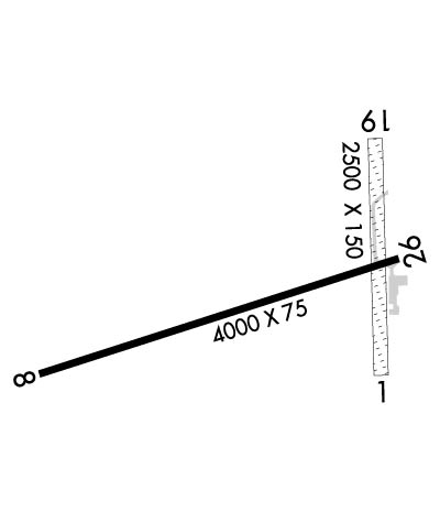
Runway Identifications
Runway Identification: 01/19Length: 2500 ft
Width: 150 ft
Surface: ASPHALT GRASS-FAIR CONDITION
Edge lights: Treatment: NONE
| | Runway: 01 | | Runway: 19 |
| Mag heading: | 5° | Mag heading: | 185° |
| Approach: | | Approach: | |
| Pattern: | Left Traffic | Pattern: | Left Traffic |
| Markings: | | Markings: | |
| Marking Condition: | 3 FT YELLOW CONES. | Marking Condition: | 3 FT YELLOW CONES. |
| Arresting Dev: | | Arresting Dev: | |
| Lat & Long: | N4600.4 W08344.4 | Lat. & Long.: | N4600.8 W08344.4 |
| Elev: | N/A | Elev: | N/A |
| TCH: | | TCH: | |
| Visual Glide Path: | | Visual Glide Path: | |
| Displaced Threshold: | No | Displaced Threshold: | No |
| Touchdown Zone: | NO | Touchdown Zone: | NO |
| Touchdown Elev.: | | Touchdown Elev.: | |
| Visual Glide Slope: | | Visual Glide Slope: | |
| RVR Equipment: | | RVR Equipment: | |
| RVV Equipment: | NO | RVV Equipment: | NO |
| Approach Lights: | | Approach Lights: | |
| REIL: | NO | REIL: | NO |
| Centerline Lights: | NO | Centerline Lights: | NO |
| Touchdown lights: | NO | Touchdown lights: | NO |
| Runway Category: | Runway with a Visual Approach | Runway Category: | Runway with a Visual Approach |
| Declared Distances: | | Declared Distances: | |
| Obstructions: | TREES | Obstructions: | TREES |
| Marked: | NOT Marked/Lighted | Marked: | NOT Marked/Lighted |
| Clearance slope: | 1:1 | Clearance slope: | 1:1 |
| Obstruction height: | 59 feet AGL | Obstruction height: | 71 feet AGL |
| Dist. from runway: | 0 feet | Dist. from runway: | 0 feet |
| Centerline offset: | 125 right of centerline | Centerline offset: | 121 feet left of centerline |
| Comments: | | Comments: | |
Runway Identification: 08/26Length: 4000 ft
Width: 75 ft
Surface: ASPHALT-FAIR CONDITION
Edge lights: Medium IntensityTreatment: NONE
| | Runway: 08 | | Runway: 26 |
| Mag heading: | 79° | Mag heading: | 259° |
| Rwy Slope: | -.05% Down | Rwy Slope: | .05% Up |
| Approach: | | Approach: | |
| Pattern: | Left Traffic | Pattern: | Left Traffic |
| Markings: | NONPRECISION INSTRUMENT | Markings: | NONPRECISION INSTRUMENT |
| Marking Condition: | GOOD | Marking Condition: | GOOD |
| Arresting Dev: | | Arresting Dev: | |
| Lat & Long: | N4600.4 W08345.2 | Lat. & Long.: | N4600.6 W08344.3 |
| Elev: | 659.4 ft. MSL | Elev: | 657.4 ft. MSL |
| TCH: | 35 ft. AGL | TCH: | 25 ft. AGL |
| Visual Glide Path: | 3.00 degrees | Visual Glide Path: | 3.00 degrees |
| Displaced Threshold: | 650 feet | Displaced Threshold: | 170 feet |
| Touchdown Zone: | YES | Touchdown Zone: | YES |
| Touchdown Elev.: | 660.7 feet | Touchdown Elev.: | 660.7 feet |
| Visual Glide Slope: | 2-Light PAPI on LEFT side of Runway | Visual Glide Slope: | 2-Light PAPI on LEFT side of Runway |
| RVR Equipment: | | RVR Equipment: | |
| RVV Equipment: | NO | RVV Equipment: | NO |
| Approach Lights: | | Approach Lights: | |
| REIL: | NO | REIL: | NO |
| Centerline Lights: | NO | Centerline Lights: | NO |
| Touchdown lights: | NO | Touchdown lights: | NO |
| Runway Category: | Runway with a Non-precision Approach | Runway Category: | Runway with a Non-precision Approach |
| Declared Distances: | | Declared Distances: | |
| Obstructions: | TREES | Obstructions: | ROAD |
| Marked: | NOT Marked/Lighted | Marked: | NOT Marked/Lighted |
| Clearance slope: | 1:1; APCH RATIO 1:1 TO DTHR OVR 80 FT TREES, 0 FT DIST, 250 FT L. | Clearance slope: | 1:1; APCH RATIO 4:1 TO DTHR OVR 75 FT TREE, 321 FT DIST, 247 FT L. |
| Obstruction height: | 30 feet AGL | Obstruction height: | 15 feet AGL |
| Dist. from runway: | 200 feet | Dist. from runway: | 200 feet |
| Centerline offset: | 175 left of centerline | Centerline offset: | 125 feet right of centerline |
| Comments: | +4 FT FENCE, 20 FT DIST; +10 FT HILL, 10 FT DIST, 50 FT L; +18 FT BLDG, 97 FT DIST, 50 FT R; +50 FT TREES, 20 FT DIST, 90 FT L/R. | Comments: | +6 FT FENCE, 54 FT DIST; +15 FT ROAD, 112 FT DIST; +20 FT BLDG, 0 FT DIST, 200 FT R. |

