Current Weather/Notams (Metars, TAFs, Notams, NWS Forecast, PIREPS, and nearby weather)
Customs Information Send updates to Support@FltPlan.com
Customs Not Available
Database effective 04/18/2024
Airport Diagram might not be current.
|
| Facility Name: | BEAUREGARD RGNL |
| City Name: | DE RIDDER |
| County: | BEAUREGARD |
| State abbrev: | LA |
| State Name: | LOUISIANA |
| | |
| Ownership: | PUBLICLY OWNED |
| Use: | OPEN TO THE PUBLIC |
| Owner's Name: | BEAUREGARD PARISH |
| Address: | 1220 1ST AVE |
| | DERIDDER, LA 70634 |
| Owner's Phone: | 337-463-8250 |
| | |
| Manager's Name: | SAM LACK |
| Address: | 1220 1ST AVE |
| | DERIDDER, LA 70634 |
| Phone: | 337-463-8250 |
| | |
| FAA Region: | SOUTHWEST |
| FAA Field Office: | LNM |
Runway Identifications
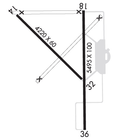
Runway Identification: 14/32Length: 4218 ft
Width: 60 ft
Surface: ASPHALT-GOOD CONDITION
Edge lights: Treatment: NONE
| | Runway: 14 | | Runway: 32 |
| Mag heading: | 130° | Mag heading: | 310° |
| Rwy Slope: | .03% Up | Rwy Slope: | -.03% Down |
| Approach: | | Approach: | |
| Pattern: | Left Traffic | Pattern: | Left Traffic |
| Markings: | BASIC | Markings: | BASIC |
| Marking Condition: | FAIR | Marking Condition: | FAIR |
| Arresting Dev: | | Arresting Dev: | |
| Lat & Long: | N3050.2 W09320.9 | Lat. & Long.: | N3049.8 W09320.3 |
| Elev: | 191.5 ft. MSL | Elev: | 192.8 ft. MSL |
| TCH: | | TCH: | |
| Visual Glide Path: | | Visual Glide Path: | |
| Displaced Threshold: | 454 feet | Displaced Threshold: | No |
| Touchdown Zone: | YES | Touchdown Zone: | YES |
| Touchdown Elev.: | 194.1 feet | Touchdown Elev.: | 194.0 feet |
| Visual Glide Slope: | | Visual Glide Slope: | |
| RVR Equipment: | | RVR Equipment: | |
| RVV Equipment: | NO | RVV Equipment: | NO |
| Approach Lights: | | Approach Lights: | |
| REIL: | NO | REIL: | NO |
| Centerline Lights: | NO | Centerline Lights: | NO |
| Touchdown lights: | NO | Touchdown lights: | NO |
| Runway Category: | Runway with a Visual Approach | Runway Category: | Runway with a Visual Approach |
| Declared Distances: | | Declared Distances: | |
| Obstructions: | TREES | Obstructions: | TREES |
| Marked: | NOT Marked/Lighted | Marked: | NOT Marked/Lighted |
| Clearance slope: | 15:1; APCH SLP 20:1 TO DSPLCD THR. | Clearance slope: | 22:1 |
| Obstruction height: | 81 feet AGL | Obstruction height: | 65 feet AGL |
| Dist. from runway: | 1426 feet | Dist. from runway: | 1635 feet |
| Centerline offset: | 163 right of centerline | Centerline offset: | 114 feet left of centerline |
| Comments: | | Comments: | |
Runway Identification: 18/36Length: 5494 ft
Width: 100 ft
Surface: CONCRETE ASPHALT-GOOD CONDITION
Edge lights: Medium IntensityTreatment: AGGREGATE FRICTION SEAL COAT
| | Runway: 18 | | Runway: 36 |
| Mag heading: | 175° | Mag heading: | 355° |
| Rwy Slope: | -.08% Down | Rwy Slope: | .08% Up |
| Approach: | | Approach: | LOCALIZER |
| Pattern: | Left Traffic | Pattern: | Left Traffic |
| Markings: | NONPRECISION INSTRUMENT | Markings: | NONPRECISION INSTRUMENT |
| Marking Condition: | POOR; RUNWAY 18 MARKINGS FADED | Marking Condition: | POOR; RUNWAY 36 MARKINGS FADED |
| Arresting Dev: | | Arresting Dev: | |
| Lat & Long: | N3050.3 W09320.3 | Lat. & Long.: | N3049.4 W09320.3 |
| Elev: | 201.1 ft. MSL | Elev: | 196.7 ft. MSL |
| TCH: | 50 ft. AGL | TCH: | 50 ft. AGL |
| Visual Glide Path: | 3.00 degrees | Visual Glide Path: | 3.00 degrees |
| Displaced Threshold: | No | Displaced Threshold: | No |
| Touchdown Zone: | YES | Touchdown Zone: | YES |
| Touchdown Elev.: | 201.8 feet | Touchdown Elev.: | 196.9 feet |
| Visual Glide Slope: | 4-Light PAPI on RIGHT side of Runway | Visual Glide Slope: | 4-Light PAPI on LEFT side of Runway |
| RVR Equipment: | | RVR Equipment: | |
| RVV Equipment: | NO | RVV Equipment: | NO |
| Approach Lights: | | Approach Lights: | ODALS - omnidirectional approach lighting system |
| REIL: | YES | REIL: | NO |
| Centerline Lights: | NO | Centerline Lights: | NO |
| Touchdown lights: | NO | Touchdown lights: | NO |
| Runway Category: | Runway with a Non-precision Approach having visibility minimums greater than 3/4 mile | Runway Category: | Runway with a Non-precision Approach having visibility minimums greater than 3/4 mile |
| Declared Distances: | | Declared Distances: | |
| Obstructions: | TREES | Obstructions: | TREES |
| Marked: | NOT Marked/Lighted | Marked: | NOT Marked/Lighted |
| Clearance slope: | 23:1 | Clearance slope: | 26:1 |
| Obstruction height: | 95 feet AGL | Obstruction height: | 74 feet AGL |
| Dist. from runway: | 2437 feet | Dist. from runway: | 2169 feet |
| Centerline offset: | | Centerline offset: | 226 feet right of centerline |
| Comments: | | Comments: | |

