Current Weather/Notams (Metars, TAFs, Notams, NWS Forecast, PIREPS, and nearby weather)
Customs Information Send updates to Support@FltPlan.com
Phone 630-208-6490Fax 630-208-6491Comments Mon-Fri 1100-1900 *1 hr advance notice required 3 hrs after hours *Maximum passengers per flight: 20 *M-F Call prior to 1800 on preceding weekday. *WKND Call prior to 1800 preceding Friday. Customs fee charged.
Database effective 05/16/2024
Airport Diagram might not be current. Facility Name: DUPAGE City Name: CHICAGO/WEST CHICAGO County: DU PAGE State abbrev: IL State Name: ILLINOIS Ownership: PUBLICLY OWNED Use: OPEN TO THE PUBLIC Owner's Name: DUPAGE ARPT AUTH Address: 2700 INTERNATIONAL DRIVE STE 200 WEST CHICAGO, IL 60185-0787 Owner's Phone: 630-584-2211 Manager's Name: MARK DOLES Address: 2700 INT'L DRIVE, STE 200; EMAIL ADDRESS: MDOLES@DUPAGEAIRPORT.COM (ALL LOWER CASE) WEST CHICAGO, IL 60185-0787 Phone: 630-584-2211 FAA Region: GREAT LAKES FAA Field Office: CHI
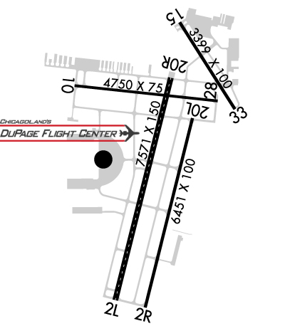
Runway Identifications Help
Runway Identification: 02L/20R Length: 7571 ftWidth: 150 ftSurface: CONCRETE-GOOD CONDITIONEdge lights: High Intensity Treatment: GROOVED Runway: 02L Runway: 20R Mag heading: 15° Mag heading: 195° Rwy Slope: .06% Up Rwy Slope: -.06% Down Approach: ILS Approach: Pattern: Left Traffic Pattern: Left Traffic Markings: PRECISION INSTRUMENT Markings: PRECISION INSTRUMENT Marking Condition: GOOD Marking Condition: GOOD Arresting Dev: Arresting Dev: Lat & Long: N4153.6 W08815.2 Lat. & Long.: N4154.9 W08814.8 Elev: 750.8 ft. MSL Elev: 755.5 ft. MSL TCH: TCH: 40 ft. AGL Visual Glide Path: Visual Glide Path: 3.00 degrees Displaced Threshold: No Displaced Threshold: No Touchdown Zone: YES Touchdown Zone: YES Touchdown Elev.: 753.7 feet Touchdown Elev.: 757.1 feet Visual Glide Slope: Visual Glide Slope: 4-Light PAPI on LEFT side of Runway RVR Equipment: TOUCHDOWN RVR Equipment: ROLLOUT RVV Equipment: NO RVV Equipment: NO Approach Lights: MALSR - 1,400 foot medium intensity approach lighting system with runway alignment indicator lights Approach Lights: REIL: NO REIL: NO Centerline Lights: YES Centerline Lights: YES Touchdown lights: YES Touchdown lights: NO Runway Category: Precision Instrument Runway Runway Category: Runway with a Non-precision Approach having visibility minimums greater than 3/4 mile Declared Distances: Declared Distances:
Runway Identification: 02R/20L Length: 6451 ftWidth: 100 ftSurface: CONCRETE-GOOD CONDITIONEdge lights: Medium Intensity Treatment: GROOVED Runway: 02R Runway: 20L Mag heading: 15° Mag heading: 195° Rwy Slope: .12% Up Rwy Slope: -.12% Down Approach: Approach: Pattern: Right Traffic Pattern: Left Traffic Markings: NONPRECISION INSTRUMENT Markings: NONPRECISION INSTRUMENT Marking Condition: GOOD Marking Condition: GOOD Arresting Dev: Arresting Dev: Lat & Long: N4153.6 W08815.0 Lat. & Long.: N4154.6 W08814.7 Elev: 750.5 ft. MSL Elev: 758.5 ft. MSL TCH: TCH: Visual Glide Path: Visual Glide Path: Displaced Threshold: No Displaced Threshold: No Touchdown Zone: YES Touchdown Zone: YES Touchdown Elev.: 751.1 feet Touchdown Elev.: 758.5 feet Visual Glide Slope: Visual Glide Slope: RVR Equipment: RVR Equipment: RVV Equipment: NO RVV Equipment: NO Approach Lights: Approach Lights: REIL: NO REIL: NO Centerline Lights: NO Centerline Lights: NO Touchdown lights: NO Touchdown lights: NO Runway Category: Runway with a Non-precision Approach having visibility minimums greater than 3/4 mile Runway Category: Runway with a Non-precision Approach having visibility minimums greater than 3/4 mile Declared Distances: Declared Distances:
Runway Identification: 10/28 Length: 4750 ftWidth: 75 ftSurface: ASPHALT-GOOD CONDITIONEdge lights: High Intensity Treatment: GROOVED Runway: 10 Runway: 28 Mag heading: 97° Mag heading: 277° Rwy Slope: .05% Up Rwy Slope: -.05% Down Approach: ILS Approach: Pattern: Left Traffic Pattern: Left Traffic Markings: PRECISION INSTRUMENT Markings: PRECISION INSTRUMENT Marking Condition: GOOD Marking Condition: GOOD Arresting Dev: Arresting Dev: Lat & Long: N4154.8 W08815.5 Lat. & Long.: N4154.7 W08814.5 Elev: 753.3 ft. MSL Elev: 755.9 ft. MSL TCH: 50 ft. AGL TCH: 40 ft. AGL Visual Glide Path: 3.00 degrees Visual Glide Path: 3.00 degrees Displaced Threshold: No Displaced Threshold: No Touchdown Zone: YES Touchdown Zone: YES Touchdown Elev.: 756.3 feet Touchdown Elev.: 756.6 feet Visual Glide Slope: 4-BOX VASI ON LEFT SIDE OF RUNWAY; UNUSBL BYD 5 DEG RIGHT AND LEFT OF CNTRLN. Visual Glide Slope: 4-Light PAPI on LEFT side of Runway RVR Equipment: RVR Equipment: RVV Equipment: NO RVV Equipment: NO Approach Lights: RLLS Approach Lights: REIL: YES REIL: YES Centerline Lights: NO Centerline Lights: NO Touchdown lights: NO Touchdown lights: NO Runway Category: Precision Instrument Runway Runway Category: Runway with a Visual Approach Declared Distances: Declared Distances: Obstructions: BLDG Obstructions: Marked: NOT Marked/Lighted Marked: Clearance slope: 44:1 Clearance slope: 20:1 Obstruction height: 34 feet AGL Obstruction height: Dist. from runway: 1743 feet Dist. from runway: Centerline offset: Centerline offset: Comments: Comments:
Runway Identification: 15/33 Length: 3399 ftWidth: 100 ftSurface: ASPHALT-GOOD CONDITIONEdge lights: Medium Intensity Treatment: NONE Runway: 15 Runway: 33 Mag heading: 149° Mag heading: 329° Rwy Slope: .02% Up Rwy Slope: -.02% Down Approach: Approach: Pattern: Left Traffic Pattern: Left Traffic Markings: BASIC Markings: BASIC Marking Condition: GOOD Marking Condition: GOOD Arresting Dev: Arresting Dev: Lat & Long: N4155.2 W08814.7 Lat. & Long.: N4154.7 W08814.3 Elev: 756.9 ft. MSL Elev: 757.6 ft. MSL TCH: 42 ft. AGL TCH: Visual Glide Path: 3.90 degrees Visual Glide Path: Displaced Threshold: No Displaced Threshold: 190 feet Touchdown Zone: YES Touchdown Zone: YES Touchdown Elev.: 757.2 feet Touchdown Elev.: 757.8 feet Visual Glide Slope: 4-Light PAPI on RIGHT side of Runway Visual Glide Slope: RVR Equipment: RVR Equipment: RVV Equipment: NO RVV Equipment: NO Approach Lights: Approach Lights: REIL: YES REIL: YES Centerline Lights: NO Centerline Lights: NO Touchdown lights: NO Touchdown lights: NO Runway Category: Runway with a Visual Approach Runway Category: Runway with a Visual Approach Declared Distances: Declared Distances: Obstructions: TREE Obstructions: TREE Marked: NOT Marked/Lighted Marked: NOT Marked/Lighted Clearance slope: 17:1 Clearance slope: 12:1; APCH RATIO IS 20:1 TO DSPLCD THLD. Obstruction height: 87 feet AGL Obstruction height: 54 feet AGL Dist. from runway: 1750 feet Dist. from runway: 893 feet Centerline offset: 205 right of centerline Centerline offset: 183 feet left of centerline Comments: Comments: +13 FT ROAD 199 FT FM RY END 125 FT R.