Current Weather/Notams (Metars, TAFs, Notams, NWS Forecast, PIREPS, and nearby weather)
Customs Information Send updates to Support@FltPlan.com
Customs Not Available
Database effective 05/16/2024
Airport Diagram might not be current.
|
| Facility Name: | DELAWARE MUNI/JIM MOORE FLD |
| City Name: | DELAWARE |
| County: | DELAWARE |
| State abbrev: | OH |
| State Name: | OHIO |
| | |
| Ownership: | PUBLICLY OWNED |
| Use: | OPEN TO THE PUBLIC |
| Owner's Name: | CITY OF DELAWARE |
| Address: | 1 S SANDUSKY ST |
| | DELAWARE, OH 43015-2326 |
| Owner's Phone: | 740-203-1800 |
| | |
| Manager's Name: | KEVIN PIATT |
| Address: | 1075 PITTSBURGH DR |
| | DELAWARE, OH 43015-3848 |
| Phone: | 740-203-1870; AFT HRS 740-203-1870, OPTION 9. |
| | |
| FAA Region: | GREAT LAKES |
| FAA Field Office: | DET |
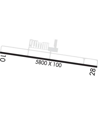
Runway Identifications
Runway Identification: 10/28Length: 5800 ft
Width: 100 ft
Surface: ASPHALT-GOOD CONDITION
Edge lights: Medium IntensityTreatment: GROOVED
Weight: PCN 39 /F/C/X/T
| | Runway: 10 | | Runway: 28 |
| Mag heading: | 104° | Mag heading: | 284° |
| Rwy Slope: | .01% Up | Rwy Slope: | -.01% Down |
| Approach: | | Approach: | |
| Pattern: | Left Traffic | Pattern: | Left Traffic |
| Markings: | NONPRECISION INSTRUMENT | Markings: | NONPRECISION INSTRUMENT |
| Marking Condition: | GOOD | Marking Condition: | GOOD |
| Arresting Dev: | | Arresting Dev: | |
| Lat & Long: | N4016.8 W08307.4 | Lat. & Long.: | N4016.7 W08306.2 |
| Elev: | 944.2 ft. MSL | Elev: | 944.7 ft. MSL |
| TCH: | 43 ft. AGL | TCH: | 41 ft. AGL |
| Visual Glide Path: | 3.00 degrees | Visual Glide Path: | 3.00 degrees |
| Displaced Threshold: | No | Displaced Threshold: | No |
| Touchdown Zone: | YES | Touchdown Zone: | YES |
| Touchdown Elev.: | 945.1 feet | Touchdown Elev.: | 944.8 feet |
| Visual Glide Slope: | 4-Light PAPI on LEFT side of Runway | Visual Glide Slope: | 4-Light PAPI on LEFT side of Runway; PAPI UNUSBL BYD 8 DEGS RIGHT OF CNTRLN. |
| RVR Equipment: | | RVR Equipment: | |
| RVV Equipment: | NO | RVV Equipment: | NO |
| Approach Lights: | | Approach Lights: | |
| REIL: | YES | REIL: | YES |
| Centerline Lights: | NO | Centerline Lights: | NO |
| Touchdown lights: | NO | Touchdown lights: | NO |
| Runway Category: | Runway with a Non-precision Approach having visibility minimums greater than 3/4 mile | Runway Category: | Runway with a Non-precision Approach having visibility minimums greater than 3/4 mile |
| Declared Distances: | | Declared Distances: | |
| Obstructions: | HILL | Obstructions: | TREES |
| Marked: | NOT Marked/Lighted | Marked: | NOT Marked/Lighted |
| Clearance slope: | 19:1 | Clearance slope: | 17:1 |
| Obstruction height: | 144 feet AGL | Obstruction height: | 75 feet AGL |
| Dist. from runway: | 3061 feet | Dist. from runway: | 1476 feet |
| Centerline offset: | 314 right of centerline | Centerline offset: | 230 feet left of centerline |
| Comments: | | Comments: | |

