Current Weather/Notams (Metars, TAFs, Notams, NWS Forecast, PIREPS, and nearby weather)
Customs Information Send updates to Support@FltPlan.com
Customs Not Available
Database effective 05/16/2024
Airport Diagram might not be current.
|
| Facility Name: | COLUMBIA GORGE RGNL/THE DALLES MUNI |
| City Name: | THE DALLES |
| County: | KLICKITAT |
| State abbrev: | OR |
| State Name: | OREGON |
| | |
| Ownership: | PUBLICLY OWNED |
| Use: | OPEN TO THE PUBLIC |
| Owner's Name: | CITY OF THE DALLES/KLICKITAT COUNTY |
| Address: | PO BOX 285 |
| | DALLES PORT, WA 98617 |
| Owner's Phone: | 509-767-2272 |
| | |
| Manager's Name: | JEFF RENARD |
| Address: | PO BOX 285 |
| | DALLES PORT, WA 98617 |
| Phone: | 509-767-2272; ADNL CTC - 541-288-6766. MANAGER@FLYCGRA.COM. |
| | |
| FAA Region: | NORTHWEST MOUNTAIN |
| FAA Field Office: | SEA |
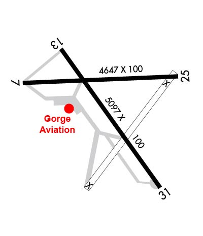
Runway Identifications
Runway Identification: 07/25Length: 4647 ft
Width: 100 ft
Surface: ASPHALT-GOOD CONDITION
Edge lights: Medium IntensityTreatment: NONE
| | Runway: 07 | | Runway: 25 |
| Mag heading: | 73° | Mag heading: | 253° |
| Rwy Slope: | .68% Up | Rwy Slope: | -.68% Down |
| Approach: | | Approach: | LDA/DME |
| Pattern: | Left Traffic | Pattern: | Left Traffic |
| Markings: | PRECISION INSTRUMENT | Markings: | PRECISION INSTRUMENT |
| Marking Condition: | FAIR | Marking Condition: | FAIR |
| Arresting Dev: | | Arresting Dev: | |
| Lat & Long: | N4537.2 W12110.7 | Lat. & Long.: | N4537.3 W12109.6 |
| Elev: | 211.1 ft. MSL | Elev: | 242.7 ft. MSL |
| TCH: | | TCH: | |
| Visual Glide Path: | | Visual Glide Path: | |
| Displaced Threshold: | 440 feet | Displaced Threshold: | 196 feet |
| Touchdown Zone: | YES | Touchdown Zone: | YES |
| Touchdown Elev.: | 239.5 feet | Touchdown Elev.: | 243.3 feet |
| Visual Glide Slope: | | Visual Glide Slope: | |
| RVR Equipment: | | RVR Equipment: | |
| RVV Equipment: | NO | RVV Equipment: | NO |
| Approach Lights: | | Approach Lights: | |
| REIL: | NO | REIL: | NO |
| Centerline Lights: | NO | Centerline Lights: | NO |
| Touchdown lights: | NO | Touchdown lights: | NO |
| Runway Category: | Runway with a Visual Approach | Runway Category: | Runway with a Visual Approach |
| Declared Distances: | | Declared Distances: | |
| Obstructions: | TREES | Obstructions: | |
| Marked: | NOT Marked/Lighted | Marked: | |
| Clearance slope: | 13:1; RWY 07 , SLP 39:1 TO DTHR. | Clearance slope: | 50:1; THLD DSPLCD TO PROVIDE SAFETY AREA. |
| Obstruction height: | 24 feet AGL | Obstruction height: | |
| Dist. from runway: | 516 feet | Dist. from runway: | |
| Centerline offset: | | Centerline offset: | |
| Comments: | RWY 07 +15 FTROAD, 0 FT FM END, 200 FT R. | Comments: | |
Runway Identification: 13/31Length: 5097 ft
Width: 100 ft
Surface: ASPHALT-GOOD CONDITION
Edge lights: Medium IntensityTreatment: NONE
Weight: PCN 32 /F/C/X/T
| | Runway: 13 | | Runway: 31 |
| Mag heading: | 130° | Mag heading: | 310° |
| Rwy Slope: | .55% Up | Rwy Slope: | -.55% Down |
| Approach: | | Approach: | |
| Pattern: | Left Traffic | Pattern: | Left Traffic |
| Markings: | BASIC | Markings: | BASIC |
| Marking Condition: | GOOD | Marking Condition: | GOOD |
| Arresting Dev: | | Arresting Dev: | |
| Lat & Long: | N4537.4 W12110.4 | Lat. & Long.: | N4536.7 W12109.7 |
| Elev: | 210.9 ft. MSL | Elev: | 238.9 ft. MSL |
| TCH: | | TCH: | |
| Visual Glide Path: | | Visual Glide Path: | |
| Displaced Threshold: | 200 feet | Displaced Threshold: | No |
| Touchdown Zone: | YES | Touchdown Zone: | YES |
| Touchdown Elev.: | 240.3 feet | Touchdown Elev.: | 242.1 feet |
| Visual Glide Slope: | | Visual Glide Slope: | |
| RVR Equipment: | | RVR Equipment: | |
| RVV Equipment: | NO | RVV Equipment: | NO |
| Approach Lights: | | Approach Lights: | |
| REIL: | NO | REIL: | YES |
| Centerline Lights: | NO | Centerline Lights: | NO |
| Touchdown lights: | NO | Touchdown lights: | NO |
| Runway Category: | Runway with a Visual Approach | Runway Category: | Runway with a Visual Approach |
| Declared Distances: | | Declared Distances: | |
| Obstructions: | TREES | Obstructions: | |
| Marked: | NOT Marked/Lighted | Marked: | |
| Clearance slope: | 15:1; RWY 13 APCH SLP 19:1 TO DTHR. | Clearance slope: | 50:1 |
| Obstruction height: | 100 feet AGL | Obstruction height: | |
| Dist. from runway: | 1733 feet | Dist. from runway: | |
| Centerline offset: | | Centerline offset: | |
| Comments: | | Comments: | |

