Current Weather/Notams (Metars, TAFs, Notams, NWS Forecast, PIREPS, and nearby weather)
Customs Information Send updates to Support@FltPlan.com
Customs Not Available
Database effective 04/18/2024
Airport Diagram might not be current.
|
| Facility Name: | BARABOO/WISCONSIN DELLS RGNL |
| City Name: | BARABOO |
| County: | SAUK |
| State abbrev: | WI |
| State Name: | WISCONSIN |
| | |
| Ownership: | PUBLICLY OWNED |
| Use: | OPEN TO THE PUBLIC |
| Owner's Name: | AIRPORT COMMISSION; CITY OF BARABOO; CITY OF WISCONSIN DELLS - TOWN & VILLAGE OF LAKE DELTON. |
| Address: | PO BOX 50 |
| | LAKE DELTON, WI 53940 |
| Owner's Phone: | 608-254-2558 |
| | |
| Manager's Name: | TIM MCCUMBER |
| Address: | PO BOX 50 |
| | LAKE DELTON, WI 53940 |
| Phone: | 608-254-2558; EXTENSION 227 |
| | |
| FAA Region: | GREAT LAKES |
| FAA Field Office: | CHI |
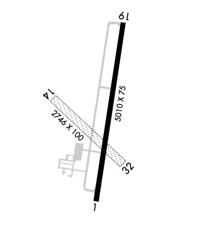
Runway Identifications
Runway Identification: 01/19Length: 5010 ft
Width: 100 ft
Surface: ASPHALT
Edge lights: Medium IntensityTreatment: NONE
| | Runway: 01 | | Runway: 19 |
| Mag heading: | 10° | Mag heading: | 190° |
| Rwy Slope: | -.19% Down | Rwy Slope: | .19% Up |
| Approach: | LOC/DME | Approach: | |
| Pattern: | Left Traffic | Pattern: | Left Traffic |
| Markings: | NONPRECISION INSTRUMENT | Markings: | NONPRECISION INSTRUMENT |
| Marking Condition: | GOOD | Marking Condition: | GOOD |
| Arresting Dev: | | Arresting Dev: | |
| Lat & Long: | N4330.9 W08946.3 | Lat. & Long.: | N4331.8 W08946.1 |
| Elev: | 976.8 ft. MSL | Elev: | 967.2 ft. MSL |
| TCH: | 32 ft. AGL | TCH: | 32 ft. AGL |
| Visual Glide Path: | 3.00 degrees | Visual Glide Path: | 3.00 degrees |
| Displaced Threshold: | No | Displaced Threshold: | No |
| Touchdown Zone: | YES | Touchdown Zone: | YES |
| Touchdown Elev.: | 979.3 feet | Touchdown Elev.: | 978.7 feet |
| Visual Glide Slope: | 2-Light PAPI on LEFT side of Runway; PAPI UNUSBL BYD 8 DEGS LEFT OF CNTRLN. | Visual Glide Slope: | 2-Light PAPI on LEFT side of Runway |
| RVR Equipment: | | RVR Equipment: | |
| RVV Equipment: | NO | RVV Equipment: | NO |
| Approach Lights: | | Approach Lights: | |
| REIL: | YES | REIL: | YES |
| Centerline Lights: | NO | Centerline Lights: | NO |
| Touchdown lights: | NO | Touchdown lights: | NO |
| Runway Category: | Runway with a Non-precision Approach having visibility minimums greater than 3/4 mile | Runway Category: | Runway with a Non-precision Approach having visibility minimums greater than 3/4 mile |
| Declared Distances: | | Declared Distances: | |
| Obstructions: | | Obstructions: | TREES |
| Marked: | | Marked: | NOT Marked/Lighted |
| Clearance slope: | 34:1 | Clearance slope: | 27:1 |
| Obstruction height: | | Obstruction height: | 134 feet AGL |
| Dist. from runway: | | Dist. from runway: | 3820 feet |
| Centerline offset: | | Centerline offset: | 580 feet left of centerline |
| Comments: | | Comments: | |
Runway Identification: 14/32Length: 2746 ft
Width: 100 ft
Surface: GRASS-GOOD CONDITION
Edge lights: Treatment: NONE
| | Runway: 14 | | Runway: 32 |
| Mag heading: | 135° | Mag heading: | 315° |
| Rwy Slope: | .20% Up | Rwy Slope: | -.20% Down |
| Approach: | | Approach: | |
| Pattern: | Left Traffic | Pattern: | Left Traffic |
| Markings: | NONE | Markings: | NONE |
| Marking Condition: | MKD WITH YELLOW/BLACK A-FRAMES AND YELLOW CONES. | Marking Condition: | MKD WITH YELLOW/BLACK A-FRAMES AND YELLOW CONES. |
| Arresting Dev: | | Arresting Dev: | |
| Lat & Long: | N4331.4 W08946.6 | Lat. & Long.: | N4331.1 W08946.2 |
| Elev: | 971.8 ft. MSL | Elev: | 977.2 ft. MSL |
| TCH: | | TCH: | |
| Visual Glide Path: | | Visual Glide Path: | |
| Displaced Threshold: | No | Displaced Threshold: | No |
| Touchdown Zone: | YES | Touchdown Zone: | YES |
| Touchdown Elev.: | 979.3 feet | Touchdown Elev.: | 979.3 feet |
| Visual Glide Slope: | | Visual Glide Slope: | |
| RVR Equipment: | | RVR Equipment: | |
| RVV Equipment: | NO | RVV Equipment: | NO |
| Approach Lights: | | Approach Lights: | |
| REIL: | NO | REIL: | NO |
| Centerline Lights: | NO | Centerline Lights: | NO |
| Touchdown lights: | NO | Touchdown lights: | NO |
| Runway Category: | Runway with a Visual Approach | Runway Category: | Runway with a Visual Approach |
| Declared Distances: | | Declared Distances: | |
| Obstructions: | TREE | Obstructions: | |
| Marked: | NOT Marked/Lighted | Marked: | |
| Clearance slope: | 17:1 | Clearance slope: | 20:1 |
| Obstruction height: | 78 feet AGL | Obstruction height: | |
| Dist. from runway: | 1330 feet | Dist. from runway: | |
| Centerline offset: | 100 right of centerline | Centerline offset: | |
| Comments: | | Comments: | |

