Current Weather/Notams (Metars, TAFs, Notams, NWS Forecast, PIREPS, and nearby weather)
Customs Information Send updates to Support@FltPlan.com
Customs Not Available
Database effective 05/16/2024
Airport Diagram might not be current.
|
| Facility Name: | DILLON COUNTY |
| City Name: | DILLON |
| County: | DILLON |
| State abbrev: | SC |
| State Name: | SOUTH CAROLINA |
| | |
| Ownership: | PUBLICLY OWNED |
| Use: | OPEN TO THE PUBLIC |
| Owner's Name: | DILLON COUNTY |
| Address: | PO BOX 449 |
| | DILLON, SC 29536 |
| Owner's Phone: | (843) 774-1401 |
| | |
| Manager's Name: | CASSIE KINNEY |
| Address: | PO BOX 449 |
| | DILLON, SC 29536 |
| Phone: | 843-845-8529 |
| | |
| FAA Region: | SOUTHERN |
| FAA Field Office: | ATL |
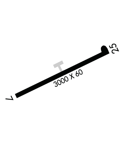
Runway Identifications
Runway Identification: 07/25Length: 3000 ft
Width: 60 ft
Surface: ASPHALT-FAIR CONDITION
Edge lights: Medium IntensityTreatment: AGGREGATE FRICTION SEAL COAT
| | Runway: 07 | | Runway: 25 |
| Mag heading: | 70° | Mag heading: | 250° |
| Rwy Slope: | -.53% Down | Rwy Slope: | .53% Up |
| Approach: | | Approach: | |
| Pattern: | Left Traffic | Pattern: | Left Traffic |
| Markings: | NONPRECISION INSTRUMENT | Markings: | NONPRECISION INSTRUMENT |
| Marking Condition: | GOOD | Marking Condition: | GOOD |
| Arresting Dev: | | Arresting Dev: | |
| Lat & Long: | N3426.8 W07922.4 | Lat. & Long.: | N3427.1 W07921.8 |
| Elev: | 133.1 ft. MSL | Elev: | 117.3 ft. MSL |
| TCH: | | TCH: | |
| Visual Glide Path: | | Visual Glide Path: | |
| Displaced Threshold: | No | Displaced Threshold: | No |
| Touchdown Zone: | YES | Touchdown Zone: | YES |
| Touchdown Elev.: | 133.1 feet | Touchdown Elev.: | 133.1 feet |
| Visual Glide Slope: | | Visual Glide Slope: | |
| RVR Equipment: | | RVR Equipment: | |
| RVV Equipment: | NO | RVV Equipment: | NO |
| Approach Lights: | | Approach Lights: | |
| REIL: | NO | REIL: | NO |
| Centerline Lights: | NO | Centerline Lights: | NO |
| Touchdown lights: | NO | Touchdown lights: | NO |
| Runway Category: | Runway with a Non-precision Approach | Runway Category: | Runway with a Visual Approach |
| Declared Distances: | | Declared Distances: | |
| Obstructions: | POLE | Obstructions: | TREE |
| Marked: | NOT Marked/Lighted | Marked: | NOT Marked/Lighted |
| Clearance slope: | 12:1 | Clearance slope: | 1:1 |
| Obstruction height: | 44 feet AGL | Obstruction height: | 50 feet AGL |
| Dist. from runway: | 773 feet | Dist. from runway: | 276 feet |
| Centerline offset: | 258 right of centerline | Centerline offset: | 135 feet left of centerline |
| Comments: | | Comments: | RWY 25 APCH HAS LINES OF TREES PARL TO THE RWY 135 FT BOTH SIDES OF CNTRLN. |

